
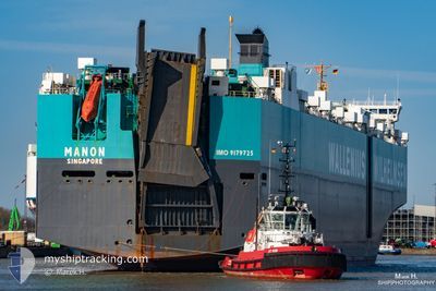
MANON
Vehicles Carrier
Current Trip
| Time Travelled | 11 days |
|---|---|
| Remaining Time | --- |
| Distance Travelled | 4334.69 nm |
| Remaining Distance | --- |
| AVG Speed | 15.4 Knopen |
| MAX Speed | 17.6 Knopen |
| AVG Wind | 12.6 knots |
| MAX Wind | 28.1 knots |
| MIN Temp | 12°C / 53.6°F |
| MAX Temp | 29.5°C / 85.1°F |
| Diepgang | 10 M |
| Positie ontvangen | 8 d geleden |
Current Position
| Lengtegraad | -15.26589° |
|---|---|
| Breedtegraat | 27.55239° |
| Status | Under way using engine |
| Snelheid | 16.2 Knopen |
| Koers | 202.8° |
| Gebied | North Atlantic Ocean |
| Station | T-AIS |
| Positie ontvangen | 8 d geleden |
Info
Information
The current position of MANON is in North Atlantic Ocean with coordinates 27.55239° / -15.26589° as reported on 2024-04-19 21:20 by AIS to our vessel tracker app. The vessel's current speed is 16.2 Knopen and is heading at the port of EAST LONDON. The estimated time of arrival as calculated by MyShipTracking vessel tracking app is 2024-05-03 04:30 LT
The vessel MANON (IMO: 9179725, MMSI: 259001000) is a Vehicles Carrier that was built in 1999 ( 25 Jaar oud ). It's sailing under the flag of [NO] Norway.
In this page you can find informations about the vessels current position, last detected port calls, and current voyage information. If the vessels is not in coverage by AIS you will find the latest position.
The current position of MANON is detected by our AIS receivers and we are not responsible for the reliability of the data. The last position was recorded while the vessel was in Coverage by the Ais receivers of our vessel tracking app.
The current draught of MANON as reported by AIS is 10 meters
Weather
| Temperature | 23°C / 73.4°F |
|---|---|
| Wind Speed | 8 knots |
| Direction | 143° SE |
| Pressure | 1013.2 hPa |
| Humidity | 81.7 % |
| Cloud Coverage | 35 % |
Featured Company
Last Port Calls
| Port | Arrival | Departure | Time In Port |
|---|---|---|---|
| 2024-04-16 03:59 | 2024-04-16 13:43 | 9 h | |
| 2024-04-13 08:40 | 2024-04-13 23:54 | 15 h | |
| 2024-04-10 01:16 | 2024-04-12 18:06 | 2 d | |
| 2024-04-06 15:45 | 2024-04-07 18:24 | 1 d | |
| 2024-03-25 16:38 | 2024-03-26 07:08 | 14 h | |
| 2024-03-22 10:15 | 2024-03-23 00:00 | 13 h |
Most Visited Ports (Last year)
| Port | Arrivals | |
|---|---|---|
| 5 | ||
| 4 | ||
| 4 | ||
| 3 | ||
| 3 | ||
| 3 |
Last Trips
| Origin | Departure | Destination | Arrival | Distance | |
|---|---|---|---|---|---|
| 2024-04-14 00:54 | 2024-04-16 05:59 | 593.44 nm | |||
| 2024-04-12 20:06 | 2024-04-13 09:40 | 205.57 nm | |||
| 2024-04-07 20:24 | 2024-04-10 03:16 | 398.85 nm | |||
| 2024-03-26 03:08 | 2024-04-06 17:45 | 3786.89 nm | |||
| 2024-03-22 20:00 | 2024-03-25 12:38 | 826.13 nm | |||
| 2024-01-25 19:12 | 2024-03-22 06:15 | 10576.54 nm |
Events
| Tijd | Evenement | Details | Positie / Bestemming | Info |
|---|---|---|---|---|
| 2024-04-19 21:26 | Status Changed | Default Under way using engine |
27.52471 / -15.27917
ZA ELS
|
Snelheid: 16.2 kn Koers: 202.8° |
| 2024-04-19 21:20 | Buitenbereik |
27.55239 / -15.26589
North Atlantic Ocean
ZA ELS
|
Snelheid: 16.2 kn Koers: 202.8° |
|
| 2024-04-19 16:15 | Wijzig zee gebeid | Spanish (Canary Islands) part of the North Atlantic Ocean Portuguese part of the North Atlantic Ocean |
28.85569 / -14.78035
North Atlantic Ocean
ZA ELS
|
Snelheid: 16.2 kn Koers: 193.9° |
| 2024-04-19 16:15 | Status Changed | Under way using engine Default |
28.85569 / -14.78035
ZA ELS
|
Snelheid: 16.1 kn Koers: 194° |
| 2024-04-19 16:15 | Binnenbereik |
28.85569 / -14.78035
North Atlantic Ocean
ZA ELS
|
Snelheid: 16.2 kn Koers: 193.9° |
|
| 2024-04-18 12:08 | Status Changed | Default Under way using engine |
36.39603 / -12.65140
ZA ELS
|
Snelheid: 16.3 kn Koers: 192.6° |
| 2024-04-18 12:06 | Buitenbereik |
36.40606 / -12.64845
North Atlantic Ocean
ZA ELS
|
Snelheid: 16.3 kn Koers: 192.6° |
|
| 2024-04-18 11:48 | Status Changed | Under way using engine Default |
36.48542 / -12.62508
ZA ELS
|
Snelheid: 16.6 kn Koers: 194° |
| 2024-04-18 11:45 | Status Changed | Default Under way using engine |
36.49925 / -12.62092
ZA ELS
|
Snelheid: 16.8 kn Koers: 194.2° |
| 2024-04-18 11:24 | Status Changed | Under way using engine Default |
36.59352 / -12.59303
ZA ELS
|
Snelheid: 16.8 kn Koers: 194° |