
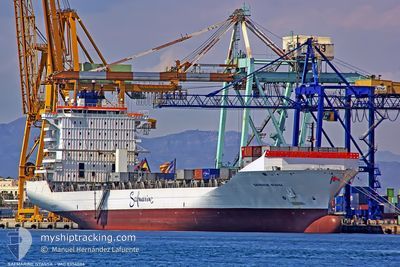
MAERSK NYASSA
Container Ship
Current Trip
| Trip Time | 6 days |
|---|---|
| Trip Distance | 933.96 nm |
| AVG Speed | 12.1 Knopen |
| MAX Speed | 17 Knopen |
| Diepgang | 10.3 M |
| AVG Wind | 17 knots |
| MAX Wind | 25.8 knots |
| MIN Temp | 27.1°C / 80.78°F |
| MAX Temp | 31.2°C / 88.16°F |
| Positie ontvangen | 21 d geleden |
Current Position
| Lengtegraad | 57.29695° |
|---|---|
| Breedtegraat | 24.90128° |
| Status | Under way using engine |
| Snelheid | 15.4 Knopen |
| Koers | 137.2° |
| Gebied | Gulf of Oman |
| Station | T-AIS |
| Positie ontvangen | 21 d geleden |
Info
Information
The current position of MAERSK NYASSA is in Gulf of Oman with coordinates 24.90128° / 57.29695° as reported on 2024-05-10 10:59 by AIS to our vessel tracker app. The vessel's current speed is 15.4 Knopen and is currently inside the port of PORT QASIM.
The vessel MAERSK NYASSA (IMO: 9356086, MMSI: 477552300) is a Container Ship that was built in 2008 ( 16 Jaar oud ). It's sailing under the flag of [HK] Hong Kong.
In this page you can find informations about the vessels current position, last detected port calls, and current voyage information. If the vessels is not in coverage by AIS you will find the latest position.
The current position of MAERSK NYASSA is detected by our AIS receivers and we are not responsible for the reliability of the data. The last position was recorded while the vessel was in Coverage by the Ais receivers of our vessel tracking app.
The current draught of MAERSK NYASSA as reported by AIS is 10.3 meters
Weather
| Temperature | 30.6°C / 87.08°F |
|---|---|
| Wind Speed | 10 knots |
| Direction | 217° SW |
| Pressure | 1001.2 hPa |
| Humidity | 72.5 % |
| Cloud Coverage | 20 % |
Featured Company
Last Port Calls
| Port | Arrival | Departure | Time In Port |
|---|---|---|---|
| 2024-05-31 05:12 | |||
| 2024-05-24 07:42 | 2024-05-24 13:28 | 5 h | |
| 2024-05-19 05:48 | 2024-05-20 14:24 | 1 d | |
| 2024-05-12 06:40 | 2024-05-12 21:51 | 15 h | |
| 2024-05-09 07:18 | 2024-05-09 19:13 | 11 h | |
| 2024-05-08 03:06 | 2024-05-08 21:17 | 18 h | |
| 2024-05-05 03:24 | 2024-05-06 03:28 | 1 d | |
| 2024-05-01 15:13 | 2024-05-02 14:26 | 23 h | |
| 2024-04-24 15:18 | 2024-04-27 07:26 | 2 d | |
| 2024-04-20 12:41 | 2024-04-21 12:08 | 23 h |
Most Visited Ports (Last year)
| Port | Arrivals | |
|---|---|---|
| 21 | ||
| 15 | ||
| 13 | ||
| 5 | ||
| 4 | ||
| 1 |
Last Trips
| Origin | Departure | Destination | Arrival | Distance | |
|---|---|---|---|---|---|
| 2024-05-24 17:28 | 2024-05-31 10:12 | 933.96 nm | |||
| 2024-05-20 17:24 | 2024-05-24 11:42 | 1197.54 nm | |||
| 2024-05-13 01:51 | 2024-05-19 08:48 | 1255.12 nm | |||
| 2024-05-09 23:13 | 2024-05-12 10:40 | 1009.34 nm | |||
| 2024-05-09 01:17 | 2024-05-09 11:18 | 52.36 nm | |||
| 2024-05-06 08:28 | 2024-05-08 07:06 | 826.51 nm | |||
| 2024-05-02 18:26 | 2024-05-05 08:24 | 907.52 nm | |||
| 2024-04-27 11:26 | 2024-05-01 19:13 | 995.76 nm | |||
| 2024-04-21 17:08 | 2024-04-24 19:18 | 831.02 nm | |||
| 2024-04-17 18:47 | 2024-04-20 17:41 | 906.58 nm |
Events
| Tijd | Evenement | Details | Positie / Bestemming | Info |
|---|---|---|---|---|
| 2024-05-31 05:12 | Stop beweging |
24.76667 / 67.33167
[PK] PORT QASIM
|
Snelheid: Koers: -1° |
|
| 2024-05-31 05:12 | Aankomsthaven |
|
24.76667 / 67.33167
[PK] PORT QASIM
|
Snelheid: 2.5 kn Koers: 36° |
| 2024-05-31 02:12 | Start beweging | 15.35 nm, South of SALEHAABAD ISLAND |
24.54855 / 66.98148
OMSLV
|
Snelheid: 3.4 kn Koers: 132° |
| 2024-05-27 10:44 | Stop beweging | 15.33 nm, South of SALEHAABAD ISLAND |
24.54918 / 66.98607
OMSLV
|
Snelheid: 0.3 kn Koers: 279° |
| 2024-05-24 13:28 | Vertrekhaven |
|
16.95167 / 54.04666
OMSLV
|
Snelheid: 11 kn Koers: -1° |
| 2024-05-24 13:20 | Start beweging |
16.94921 / 54.02129
[OM] SALALAH
|
Snelheid: 9.4 kn Koers: 70° |
|
| 2024-05-24 08:20 | Stop beweging |
16.94652 / 54.00922
[OM] SALALAH
|
Snelheid: 0.1 kn Koers: 67° |
|
| 2024-05-24 07:42 | Aankomsthaven |
|
16.95167 / 54.02500
[OM] SALALAH
|
Snelheid: 7.1 kn Koers: 268° |
| 2024-05-24 06:56 | Start beweging | 3.4 nm, South East of SALALAH |
16.91628 / 54.06927
OMSLV
|
Snelheid: 5.7 kn Koers: 268° |
| 2024-05-23 20:10 | Stop beweging | 3.5 nm, South East of SALALAH |
16.91667 / 54.07167
OMSLV
|
Snelheid: Koers: -1° |