

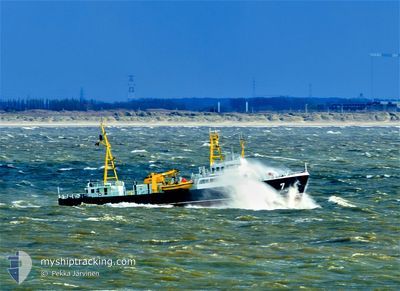
LOODSBOOT 7 PILOT
Pilot Ship

Current Trip
| Trip Time | 4 days |
|---|---|
| Trip Distance | 137.24 nm |
| AVG Speed | 10.5 Knopen |
| MAX Speed | 17 Knopen |
| Diepgang | 3.6 M |
| AVG Wind | 7.4 knots |
| MAX Wind | 10 knots |
| MIN Temp | 2.6°C / 36.68°F |
| MAX Temp | 7.5°C / 45.5°F |
| Positie ontvangen | 1 m geleden |
Current Position
| Lengtegraad | --- |
|---|---|
| Breedtegraat | --- |
| Status | Moored |
| Snelheid | |
| Koers | 157° |
| Gebied | North Sea |
| Station | T-AIS |
| Positie ontvangen | 1 m geleden |
Information
The current position of LOODSBOOT 7 PILOT is in North Sea with coordinates 51.23058° / 2.92629° as reported on 2025-02-13 11:17 by AIS to our vessel tracker app. The vessel's current speed is 0 Knopen and is currently inside the port of OOSTENDE.
The vessel LOODSBOOT 7 PILOT (IMO: 8424927, MMSI: 205110000) is a Pilot Ship that was built in 1978 ( 47 Jaar oud ). It's sailing under the flag of [BE] Belgium.
In this page you can find informations about the vessels current position, last detected port calls, and current voyage information. If the vessels is not in coverage by AIS you will find the latest position.
The current position of LOODSBOOT 7 PILOT is detected by our AIS receivers and we are not responsible for the reliability of the data. The last position was recorded while the vessel was in Coverage by the Ais receivers of our vessel tracking app.
The current draught of LOODSBOOT 7 PILOT as reported by AIS is 3.6 meters
Weather
| Temperature | 3.3°C / 37.94°F |
|---|---|
| Wind Speed | 16 knots |
| Direction | 34° NE |
| Pressure | 1022.7 hPa |
| Humidity | 75.5 % |
| Cloud Coverage | 92 % |


Featured Company
Last Port Calls
| Port | Arrival | Departure | Time In Port |
|---|---|---|---|
| 2025-02-05 14:14 | |||
| 2025-02-01 09:15 | 2025-02-01 09:31 | 15 m | |
| 2025-01-22 13:20 | 2025-01-31 05:12 | 8 d | |
| 2025-01-21 12:16 | 2025-01-21 14:58 | 2 h | |
| 2025-01-21 08:38 | 2025-01-21 08:40 | 2 m | |
| 2025-01-20 13:52 | 2025-01-20 15:22 | 1 h | |
| 2025-01-20 10:19 | 2025-01-20 10:21 | 2 m | |
| 2025-01-05 20:35 | 2025-01-17 05:12 | 11 d | |
| 2025-01-02 10:15 | 2025-01-03 05:21 | 19 h | |
| 2024-12-25 15:45 | 2025-01-02 09:28 | 7 d |
Most Visited Ports (Last year)
| Port | Arrivals | |
|---|---|---|
| 90 | ||
| 6 | ||
| 1 |
Last Trips
| Origin | Departure | Destination | Arrival | Distance | |
|---|---|---|---|---|---|
| 2025-02-01 10:31 | 2025-02-05 15:14 | 137.24 nm | |||
| 2025-01-31 06:12 | 2025-02-01 10:15 | 100.75 nm | |||
| 2025-01-21 15:58 | 2025-01-22 14:20 | 84.80 nm | |||
| 2025-01-21 09:40 | 2025-01-21 13:16 | 43.49 nm | |||
| 2025-01-20 16:22 | 2025-01-21 09:38 | 42.05 nm | |||
| 2025-01-20 11:21 | 2025-01-20 14:52 | 43.30 nm | |||
| 2025-01-17 06:12 | 2025-01-20 11:19 | 133.86 nm | |||
| 2025-01-03 06:21 | 2025-01-05 21:35 | 152.33 nm | |||
| 2025-01-02 10:28 | 2025-01-02 11:15 | 7.73 nm | |||
| 2024-12-25 14:15 | 2024-12-25 16:45 | 32.96 nm |
Events
| Tijd | Evenement | Details | Positie / Bestemming | Info |
|---|---|---|---|---|
| 2025-02-05 14:20 | Status Changed | Moored Under way using engine |
51.23056 / 2.92630
[BE] OOSTENDE
|
Snelheid: Koers: 157° |
| 2025-02-05 14:14 | Stop beweging |
51.23057 / 2.92631
[BE] OOSTENDE
|
Snelheid: Koers: 158° |
|
| 2025-02-05 14:14 | Aankomsthaven |
|
51.23060 / 2.92630
[BE] OOSTENDE
|
Snelheid: 1 kn Koers: 159° |
| 2025-02-05 11:50 | Wijzig zee gebeid | Belgian part of the North Sea Dutch part of the North Sea |
51.39393 / 3.31694
North Sea
|
Snelheid: 14.8 kn Koers: 265.4° |
| 2025-02-05 10:59 | Start beweging | 0.5 nm, South East of VLISSINGEN STATION |
51.44191 / 3.60057
VLI
|
Snelheid: 3.2 kn Koers: 146° |
| 2025-02-05 10:19 | Status Changed | Under way using engine Moored |
51.44132 / 3.59763
VLI
|
Snelheid: Koers: 290° |
| 2025-02-03 16:28 | Status Changed | Moored Under way using engine |
51.44135 / 3.59765
VLI
|
Snelheid: Koers: 294° |
| 2025-02-03 16:24 | Stop beweging | 0.45 nm, South East of VLISSINGEN STATION |
51.44136 / 3.59764
VLI
|
Snelheid: 0.1 kn Koers: 283° |
| 2025-02-03 15:40 | Wijzig zee gebeid | Dutch part of the North Sea Belgian part of the North Sea |
51.39962 / 3.35291
North Sea
|
Snelheid: 15.4 kn Koers: 87.9° |
| 2025-02-03 12:34 | Wijzig zee gebeid | Belgian part of the North Sea Dutch part of the North Sea |
51.39539 / 3.32984
North Sea
|
Snelheid: 13 kn Koers: 260.9° |