

LISA REICH
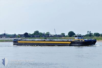
Tanker

Current Trip
| Time Travelled | 1 day |
|---|---|
| Remaining Time | --- |
| Distance Travelled | 0.51 nm |
| Remaining Distance | --- |
| AVG Speed | 6.2 Knopen |
| MAX Speed | 6.4 Knopen |
| AVG Wind | 15.4 knots |
| MAX Wind | 15.7 knots |
| MIN Temp | 11.9°C / 53.42°F |
| MAX Temp | 12.1°C / 53.78°F |
| Diepgang | 2 M |
| Positie ontvangen | 1 d geleden |
Current Position
| Lengtegraad | --- |
|---|---|
| Breedtegraat | --- |
| Status | Under way using engine |
| Snelheid | 6.3 Knopen |
| Koers | 252.2° |
| Gebied | North Sea |
| Station | T-AIS |
| Positie ontvangen | 1 d geleden |
Information
The current position of LISA REICH is in North Sea with coordinates 51.66427° / 7.70644° as reported on 2025-02-24 13:23 by AIS to our vessel tracker app. The vessel's current speed is 6.3 Knopen
The vessel LISA REICH (MMSI: 211394510) is a Tanker It's sailing under the flag of [DE] Germany.
In this page you can find informations about the vessels current position, last detected port calls, and current voyage information. If the vessels is not in coverage by AIS you will find the latest position.
The current position of LISA REICH is detected by our AIS receivers and we are not responsible for the reliability of the data. The last position was recorded while the vessel was in Coverage by the Ais receivers of our vessel tracking app.
The current draught of LISA REICH as reported by AIS is 2 meters
Weather
| Temperature | 11.8°C / 53.24°F |
|---|---|
| Wind Speed | 15 knots |
| Direction | 193° SSW |
| Pressure | 1015.9 hPa |
| Humidity | 62.2 % |
| Cloud Coverage | 100 % |


Featured Company
Last Port Calls
| Port | Arrival | Departure | Time In Port |
|---|---|---|---|
| 2025-02-24 12:49 | 2025-02-24 13:05 | 16 m | |
| 2025-02-23 13:19 | 2025-02-23 13:39 | 19 m | |
| 2025-02-23 05:59 | |||
| 2025-02-17 15:26 | 2025-02-17 15:50 | 24 m | |
| 2025-02-11 14:07 | 2025-02-11 14:27 | 19 m | |
| 2025-02-10 01:01 | 2025-02-10 04:45 | 3 h | |
| 2025-02-05 13:01 | 2025-02-05 13:14 | 13 m | |
| 2025-02-04 13:58 | 2025-02-05 10:23 | 20 h | |
| 2025-02-04 05:14 | |||
| 2025-01-29 16:16 | 2025-01-29 17:20 | 1 h |
Last Trips
| Origin | Departure | Destination | Arrival | Distance | |
|---|---|---|---|---|---|
| 2025-02-23 14:39 | 2025-02-24 13:49 | 3.39 nm | |||
| 2025-02-23 06:59 | 2025-02-23 14:19 | 24.12 nm | |||
| 2025-02-11 15:27 | 2025-02-17 16:26 | 8.85 nm | |||
| 2025-02-10 05:45 | 2025-02-11 15:07 | 9.02 nm | |||
| 2025-02-05 14:14 | 2025-02-10 02:01 | 105.37 nm | |||
| 2025-02-05 11:23 | 2025-02-05 14:01 | 19.95 nm | |||
| 2025-02-04 06:14 | 2025-02-04 14:58 | 86.82 nm | |||
| 2025-01-29 12:40 | 2025-01-29 17:16 | 48.17 nm | |||
| 2025-01-27 03:04 | 2025-01-27 10:59 | 42.37 nm | |||
| 2025-01-26 18:20 | 2025-01-26 20:06 | 4.00 nm |
Events
| Tijd | Evenement | Details | Positie / Bestemming | Info |
|---|---|---|---|---|
| 2025-02-24 13:23 | Buitenbereik |
51.66427 / 7.70644
North Sea
GELSENKIRCHEN
|
Snelheid: 6.3 kn Koers: 252.2° |
|
| 2025-02-24 13:05 | Vertrekhaven |
|
51.67551 / 7.75237
GELSENKIRCHEN
|
Snelheid: 5 kn Koers: 256° |
| 2025-02-24 12:49 | Aankomsthaven |
|
51.67977 / 7.78449
[DE] HAMM
|
Snelheid: 3.9 kn Koers: 265° |
| 2025-02-24 12:47 | Draught Changed | 2 2.5 |
51.67992 / 7.78711
GELSENKIRCHEN
|
Snelheid: 3.9 kn Koers: 265° |
| 2025-02-24 12:47 | Destination Changed | GELSENKIRCHEN UENTROP |
51.67992 / 7.78711
GELSENKIRCHEN
|
Snelheid: 3.9 kn Koers: 265° |
| 2025-02-24 12:47 | ETA Changed | 2025/02/24 23:59 2025/02/23 23:59 |
51.67992 / 7.78711
GELSENKIRCHEN
|
Snelheid: 3.9 kn Koers: 265° |
| 2025-02-24 12:34 | Start beweging | 1.38 nm, East of HAMM |
51.68409 / 7.81430
UENTROP
|
Snelheid: 4.6 kn Koers: 234° |
| 2025-02-24 12:13 | Stop beweging | 1.68 nm, East of HAMM |
51.68655 / 7.82137
UENTROP
|
Snelheid: 0.1 kn Koers: 242° |
| 2025-02-24 12:08 | Binnenbereik |
51.68666 / 7.82166
North Sea
|
Snelheid: 0.8 kn Koers: 240.9° |
|
| 2025-02-23 14:30 | Buitenbereik |
51.69123 / 7.83246
North Sea
UENTROP
|
Snelheid: 4.2 kn Koers: 62° |