

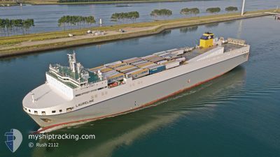
LAURELINE
Other Type

Current Trip
| Time Travelled | 13 h, 1 mins |
|---|---|
| Remaining Time | 1 day |
| Distance Travelled | 205.30 nm |
| Remaining Distance | 440.08 nm |
| AVG Speed | 14.8 Knopen |
| MAX Speed | 18.1 Knopen |
| AVG Wind | 20.5 knots |
| MAX Wind | 28 knots |
| MIN Temp | 9.6°C / 49.28°F |
| MAX Temp | 11.9°C / 53.42°F |
| Diepgang | 6.8 M |
| Positie ontvangen | 15 m geleden |
Current Position
| Lengtegraad | --- |
|---|---|
| Breedtegraat | --- |
| Status | Under way using engine |
| Snelheid | 17.5 Knopen |
| Koers | 177.1° |
| Gebied | Celtic Sea |
| Station | T-AIS |
| Positie ontvangen | 15 m geleden |
Information
The current position of LAURELINE is in Celtic Sea with coordinates 50.13616° / -5.99615° as reported on 2025-03-28 04:13 by AIS to our vessel tracker app. The vessel's current speed is 17.5 Knopen and is heading at the port of ROTTERDAM. The estimated time of arrival as calculated by MyShipTracking vessel tracking app is 2025-03-29 06:14 LT
The vessel LAURELINE (IMO: 9823352, MMSI: 248743000) is a Other Type It's sailing under the flag of [MT] Malta.
In this page you can find informations about the vessels current position, last detected port calls, and current voyage information. If the vessels is not in coverage by AIS you will find the latest position.
The current position of LAURELINE is detected by our AIS receivers and we are not responsible for the reliability of the data. The last position was recorded while the vessel was in Coverage by the Ais receivers of our vessel tracking app.
The current draught of LAURELINE as reported by AIS is 6.8 meters
Weather
| Temperature | 10.6°C / 51.08°F |
|---|---|
| Wind Speed | 19 knots |
| Direction | 296° WNW |
| Pressure | 1013.9 hPa |
| Humidity | 86.6 % |
| Cloud Coverage | 100 % |


Featured Company
Last Port Calls
| Port | Arrival | Departure | Time In Port |
|---|---|---|---|
| 2025-03-27 04:01 | 2025-03-27 15:28 | 11 h | |
| 2025-03-24 14:16 | 2025-03-25 13:27 | 23 h | |
| 2025-03-24 13:18 | 2025-03-24 14:09 | 50 m | |
| 2025-03-22 11:03 | 2025-03-22 21:22 | 10 h | |
| 2025-03-20 05:31 | 2025-03-20 20:00 | 14 h | |
| 2025-03-20 04:29 | 2025-03-20 05:22 | 52 m | |
| 2025-03-17 09:05 | 2025-03-18 15:43 | 1 d | |
| 2025-03-15 05:33 | 2025-03-15 16:29 | 10 h | |
| 2025-03-15 04:33 | 2025-03-15 05:25 | 51 m | |
| 2025-03-13 04:38 | 2025-03-13 14:42 | 10 h |
Last Trips
| Origin | Departure | Destination | Arrival | Distance | |
|---|---|---|---|---|---|
| 2025-03-25 14:27 | 2025-03-27 04:01 | 635.29 nm | |||
| 2025-03-24 15:09 | 2025-03-24 15:16 | 0.28 nm | |||
| 2025-03-22 21:22 | 2025-03-24 14:18 | 641.38 nm | |||
| 2025-03-20 21:00 | 2025-03-22 11:03 | 634.33 nm | |||
| 2025-03-20 06:22 | 2025-03-20 06:31 | 0.26 nm | |||
| 2025-03-18 15:43 | 2025-03-20 05:29 | 639.23 nm | |||
| 2025-03-15 17:29 | 2025-03-17 09:05 | 633.17 nm | |||
| 2025-03-15 06:25 | 2025-03-15 06:33 | 0.24 nm | |||
| 2025-03-13 14:42 | 2025-03-15 05:33 | 648.55 nm | |||
| 2025-03-11 14:47 | 2025-03-13 04:38 | 635.38 nm |
Events
| Tijd | Evenement | Details | Positie / Bestemming | Info |
|---|---|---|---|---|
| 2025-03-28 04:20 | Status Changed | Default Under way using engine |
50.10493 / -5.99327
NL RTM
|
Snelheid: 17.5 kn Koers: 177.1° |
| 2025-03-28 04:04 | Status Changed | Under way using engine Default |
50.17932 / -6.00014
NL RTM
|
Snelheid: 17.4 kn Koers: 178° |
| 2025-03-28 04:00 | Status Changed | Default Under way using engine |
50.20071 / -6.00013
NL RTM
|
Snelheid: 17.1 kn Koers: 180.5° |
| 2025-03-28 02:04 | Status Changed | Under way using engine Default |
50.73965 / -6.01141
NL RTM
|
Snelheid: 16.8 kn Koers: 180° |
| 2025-03-28 01:56 | Status Changed | Default Under way using engine |
50.77562 / -6.00914
NL RTM
|
Snelheid: 16.7 kn Koers: 181.2° |
| 2025-03-28 01:45 | Status Changed | Under way using engine Default |
50.82485 / -6.00611
NL RTM
|
Snelheid: 16.7 kn Koers: 183° |
| 2025-03-28 01:44 | Status Changed | Default Under way using engine |
50.83082 / -6.00575
NL RTM
|
Snelheid: 16.6 kn Koers: 182.1° |
| 2025-03-28 01:44 | Status Changed | Under way using engine Default |
50.83219 / -6.00563
NL RTM
|
Snelheid: 16.9 kn Koers: 179° |
| 2025-03-28 01:00 | Status Changed | Default Under way using engine |
51.03483 / -6.00256
NL RTM
|
Snelheid: 17.2 kn Koers: 178.9° |
| 2025-03-28 00:42 | Gevonden in zee | United Kingdom part of the Celtic Sea |
51.11947 / -6.00301
Celtic Sea
NL RTM
|
Snelheid: 17.3 kn Koers: 180.5° |