

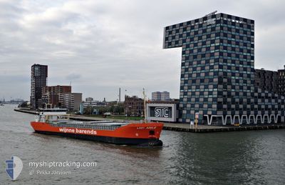
LADY ADELE
Cargo

Current Trip
| Time Travelled | 4 days |
|---|---|
| Remaining Time | 2 days |
| Distance Travelled | 402.46 nm |
| Remaining Distance | 559.96 nm |
| AVG Speed | 8 Knopen |
| MAX Speed | 11.2 Knopen |
| AVG Wind | 17.4 knots |
| MAX Wind | 31 knots |
| MIN Temp | 7.3°C / 45.14°F |
| MAX Temp | 12°C / 53.6°F |
| Diepgang | 4.9 M |
| Positie ontvangen | 1 m geleden |
Current Position
| Lengtegraad | --- |
|---|---|
| Breedtegraat | --- |
| Status | Under way using engine |
| Snelheid | 7.6 Knopen |
| Koers | 240.5° |
| Gebied | English Channel |
| Station | T-AIS |
| Positie ontvangen | 1 m geleden |
Information
The current position of LADY ADELE is in English Channel with coordinates 49.56115° / -3.97050° as reported on 2025-02-25 01:39 by AIS to our vessel tracker app. The vessel's current speed is 7.6 Knopen and is heading at the port of VIGO. The estimated time of arrival as calculated by MyShipTracking vessel tracking app is 2025-02-27 16:16 LT
The vessel LADY ADELE (IMO: 9624859, MMSI: 244730469) is a Cargo It's sailing under the flag of [NL] Netherlands.
In this page you can find informations about the vessels current position, last detected port calls, and current voyage information. If the vessels is not in coverage by AIS you will find the latest position.
The current position of LADY ADELE is detected by our AIS receivers and we are not responsible for the reliability of the data. The last position was recorded while the vessel was in Coverage by the Ais receivers of our vessel tracking app.
The current draught of LADY ADELE as reported by AIS is 4.9 meters
Weather
| Temperature | 8.5°C / 47.3°F |
|---|---|
| Wind Speed | 19 knots |
| Direction | 322° NW |
| Pressure | 1012.8 hPa |
| Humidity | 85.1 % |
| Cloud Coverage | 100 % |


Featured Company
Last Port Calls
| Port | Arrival | Departure | Time In Port |
|---|---|---|---|
| 2025-02-19 11:07 | 2025-02-20 15:20 | 1 d | |
| 2025-02-15 15:11 | 2025-02-19 11:04 | 3 d | |
| 2025-02-11 07:17 | 2025-02-11 21:35 | 14 h | |
| 2025-02-06 07:56 | 2025-02-07 08:33 | 1 d | |
| 2025-02-03 11:18 | 2025-02-05 15:19 | 2 d | |
| 2025-01-26 21:02 | 2025-01-28 08:56 | 1 d | |
| 2025-01-23 05:12 | 2025-01-24 22:49 | 1 d | |
| 2025-01-19 08:16 | 2025-01-20 21:13 | 1 d | |
| 2025-01-02 09:08 | 2025-01-03 22:07 | 1 d | |
| 2024-12-27 14:30 | 2024-12-27 15:19 | 48 m |
Most Visited Ports (Last year)
| Port | Arrivals | |
|---|---|---|
| 11 | ||
| 6 | ||
| 6 | ||
| 6 | ||
| 5 | ||
| 4 |
Last Trips
| Origin | Departure | Destination | Arrival | Distance | |
|---|---|---|---|---|---|
| 2025-02-19 12:04 | 2025-02-19 12:07 | 0.17 nm | |||
| 2025-02-11 21:35 | 2025-02-15 16:11 | 607.21 nm | |||
| 2025-02-07 08:33 | 2025-02-11 07:17 | 767.65 nm | |||
| 2025-02-05 15:19 | 2025-02-06 07:56 | 163.45 nm | |||
| 2025-01-28 09:56 | 2025-02-03 11:18 | 1337.08 nm | |||
| 2025-01-24 22:49 | 2025-01-26 22:02 | 479.69 nm | |||
| 2025-01-20 22:13 | 2025-01-23 05:12 | 507.17 nm | |||
| 2025-01-04 00:07 | 2025-01-19 09:16 | 1958.83 nm | |||
| 2024-12-27 16:19 | 2025-01-02 11:08 | 330.07 nm | |||
| 2024-12-27 10:29 | 2024-12-27 15:30 | 48.66 nm |
Events
| Tijd | Evenement | Details | Positie / Bestemming | Info |
|---|---|---|---|---|
| 2025-02-25 01:27 | Status Changed | Under way using engine Default |
49.57401 / -3.93469
ESVGO
|
Snelheid: 7.9 kn Koers: 240° |
| 2025-02-25 01:15 | Status Changed | Default Under way using engine |
49.58707 / -3.89862
ESVGO
|
Snelheid: 8.2 kn Koers: 238.4° |
| 2025-02-25 00:53 | Status Changed | Under way using engine Default |
49.61417 / -3.83195
ESVGO
|
Snelheid: 7.9 kn Koers: 239° |
| 2025-02-25 00:51 | Status Changed | Default Under way using engine |
49.61598 / -3.82747
ESVGO
|
Snelheid: 8.5 kn Koers: 239.4° |
| 2025-02-25 00:51 | ETA Changed | 2025/02/27 18:00 2025/02/25 18:00 |
49.62218 / -3.81220
ESVGO
|
Snelheid: 8.5 kn Koers: 239.4° |
| 2025-02-25 00:30 | Status Changed | Under way using engine Default |
49.64207 / -3.76230
ESVGO
|
Snelheid: 8.6 kn Koers: 237° |
| 2025-02-25 00:28 | Binnenbereik |
49.64207 / -3.76230
English Channel
ESVGO
|
Snelheid: 8.6 kn Koers: 239.1° |
|
| 2025-02-24 23:23 | Status Changed | Default Under way using engine |
49.73040 / -3.54458
ESVGO
|
Snelheid: 9.2 kn Koers: 239.7° |
| 2025-02-24 23:17 | Buitenbereik |
49.73936 / -3.52157
English Channel
ESVGO
|
Snelheid: 9.2 kn Koers: 239.7° |
|
| 2025-02-24 22:50 | Gevonden in zee | United Kingdom part of the English Channel |
49.77332 / -3.43135
English Channel
ESVGO
|
Snelheid: 9.1 kn Koers: 241° |