

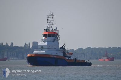
KINGFISHER
Articulated Pusher Tug
Current Trip
RUWAIS
| Time Travelled | 30 days |
|---|---|
| Remaining Time | --- |
| Distance Travelled | 3408.40 nm |
| Remaining Distance | --- |
| AVG Speed | 6.9 Knopen |
| MAX Speed | 9.6 Knopen |
| AVG Wind | 10.5 knots |
| MAX Wind | 26 knots |
| MIN Temp | 16.5°C / 61.7°F |
| MAX Temp | 28.5°C / 83.3°F |
| Diepgang | 4.2 M |
| Positie ontvangen | 1 m geleden |
Current Position
| Lengtegraad | --- |
|---|---|
| Breedtegraat | --- |
| Status | Under way using engine |
| Snelheid | |
| Koers | 197° |
| Gebied | Persian Gulf |
| Station | T-AIS |
| Positie ontvangen | 1 m geleden |
Information
The current position of KINGFISHER is in Persian Gulf with coordinates 24.18343° / 52.67215° as reported on 2025-03-29 05:34 by AIS to our vessel tracker app. The vessel's current speed is 0 Knopen
The vessel KINGFISHER (IMO: 9548885, MMSI: 245479000) is a Articulated Pusher Tug that was built in 2009 ( 16 Jaar oud ). It's sailing under the flag of [NL] Netherlands.
In this page you can find informations about the vessels current position, last detected port calls, and current voyage information. If the vessels is not in coverage by AIS you will find the latest position.
The current position of KINGFISHER is detected by our AIS receivers and we are not responsible for the reliability of the data. The last position was recorded while the vessel was in Coverage by the Ais receivers of our vessel tracking app.
The current draught of KINGFISHER as reported by AIS is 4.2 meters
Weather
| Temperature | 22.3°C / 72.14°F |
|---|---|
| Wind Speed | 7 knots |
| Direction | 91° E |
| Pressure | 1014.8 hPa |
| Humidity | 61.6 % |
| Cloud Coverage | --- |
Featured Company
Last Port Calls
| Port | Arrival | Departure | Time In Port |
|---|---|---|---|
| 2025-02-26 21:33 | 2025-02-26 21:37 | 3 m | |
| 2025-02-24 16:13 | 2025-02-24 16:17 | 4 m | |
| 2025-02-24 11:39 | 2025-02-24 11:46 | 7 m | |
| 2025-02-23 13:03 | 2025-02-23 13:06 | 2 m | |
| 2025-02-22 23:15 | 2025-02-22 23:16 | 0 m | |
| 2025-02-21 00:28 | 2025-02-21 00:30 | 1 m | |
| 2025-02-20 19:15 | 2025-02-20 19:17 | 1 m | |
| 2025-02-14 23:28 | 2025-02-14 23:38 | 10 m | |
| 2025-02-13 06:12 | 2025-02-13 06:17 | 4 m | |
| 2025-02-12 17:30 | 2025-02-12 17:31 | 1 m |
Most Visited Ports (Last year)
| Port | Arrivals | |
|---|---|---|
| 618 | ||
| 46 | ||
| 4 | ||
| 1 | ||
| 1 |
Last Trips
| Origin | Departure | Destination | Arrival | Distance | |
|---|---|---|---|---|---|
| 2025-02-24 16:17 | 2025-02-26 21:33 | 260.97 nm | |||
| 2025-02-24 11:46 | 2025-02-24 16:13 | 22.68 nm | |||
| 2025-02-23 13:06 | 2025-02-24 11:39 | 112.94 nm | |||
| 2025-02-22 23:16 | 2025-02-23 13:03 | 67.62 nm | |||
| 2025-02-21 00:30 | 2025-02-22 23:15 | 234.30 nm | |||
| 2025-02-20 19:17 | 2025-02-21 00:28 | 24.23 nm | |||
| 2025-02-14 23:38 | 2025-02-20 19:15 | 630.26 nm | |||
| 2025-02-13 06:17 | 2025-02-14 23:28 | 200.86 nm | |||
| 2025-02-12 17:31 | 2025-02-13 06:12 | 67.95 nm | |||
| 2025-02-12 05:36 | 2025-02-12 17:30 | 55.91 nm |
Events
| Tijd | Evenement | Details | Positie / Bestemming | Info |
|---|---|---|---|---|
| 2025-03-28 22:20 | Stop beweging | 3.22 nm, West of RUWAIS |
24.18222 / 52.67326
RUWAIS
|
Snelheid: Koers: 273° |
| 2025-03-28 19:15 | Start beweging | 3 nm, West of RUWAIS |
24.16524 / 52.67373
RUWAIS
|
Snelheid: 5.4 kn Koers: 32.7° |
| 2025-03-28 18:12 | Stop beweging | 3.04 nm, West of RUWAIS |
24.16318 / 52.67285
RUWAIS
|
Snelheid: 0.2 kn Koers: 160° |
| 2025-03-28 14:52 | Start beweging | 3.02 nm, West of RUWAIS |
24.15892 / 52.67344
RUWAIS
|
Snelheid: 3.6 kn Koers: 346° |
| 2025-03-28 13:36 | Stop beweging | 3.1 nm, West of RUWAIS |
24.16224 / 52.67193
RUWAIS
|
Snelheid: 0.3 kn Koers: 148° |
| 2025-03-28 13:27 | Start beweging | 3.14 nm, West of RUWAIS |
24.16740 / 52.67116
RUWAIS
|
Snelheid: 5.3 kn Koers: 171.5° |
| 2025-03-28 12:53 | Stop beweging | 3.17 nm, West of RUWAIS |
24.17011 / 52.67104
RUWAIS
|
Snelheid: 0.2 kn Koers: 194° |
| 2025-03-28 12:41 | Start beweging | 2.96 nm, West of RUWAIS |
24.17904 / 52.67710
RUWAIS
|
Snelheid: 3.5 kn Koers: 215° |
| 2025-03-28 10:42 | Stop beweging | 3.03 nm, West of RUWAIS |
24.18075 / 52.67628
RUWAIS
|
Snelheid: 0.1 kn Koers: 256° |
| 2025-03-28 07:23 | Start beweging | 3.13 nm, West of RUWAIS |
24.15492 / 52.67215
RUWAIS
|
Snelheid: 4.8 kn Koers: 26° |