
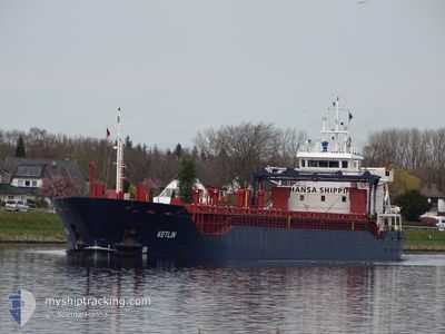
KETLIN
General Cargo
Current Trip
| Time Travelled | 23 h, 11 mins |
|---|---|
| Remaining Time | 11 h, 32 mins |
| Distance Travelled | 253.52 nm |
| Remaining Distance | 126.96 nm |
| AVG Speed | 10.6 Knopen |
| MAX Speed | 11.5 Knopen |
| AVG Wind | 5.8 knots |
| MAX Wind | 15 knots |
| MIN Temp | 1.3°C / 34.34°F |
| MAX Temp | 4.6°C / 40.28°F |
| Diepgang | 3.4 M |
| Positie ontvangen | Nu |
Current Position
| Lengtegraad | 26.20782° |
|---|---|
| Breedtegraat | 59.93093° |
| Status | Under way using engine |
| Snelheid | 10.8 Knopen |
| Koers | 75.7° |
| Gebied | Gulf of Finland |
| Station | T-AIS |
| Positie ontvangen | Nu |
Info
Information
The current position of KETLIN is in Gulf of Finland with coordinates 59.93093° / 26.20782° as reported on 2024-04-27 16:13 by AIS to our vessel tracker app. The vessel's current speed is 10.8 Knopen and is heading at the port of ST PETERSBURG. The estimated time of arrival as calculated by MyShipTracking vessel tracking app is 2024-04-28 03:46 LT
The vessel KETLIN (IMO: 9342152, MMSI: 248622000) is a General Cargo that was built in 2006 ( 18 Jaar oud ). It's sailing under the flag of [MT] Malta.
In this page you can find informations about the vessels current position, last detected port calls, and current voyage information. If the vessels is not in coverage by AIS you will find the latest position.
The current position of KETLIN is detected by our AIS receivers and we are not responsible for the reliability of the data. The last position was recorded while the vessel was in Coverage by the Ais receivers of our vessel tracking app.
The current draught of KETLIN as reported by AIS is 3.4 meters
Weather
| Temperature | 4.2°C / 39.56°F |
|---|---|
| Wind Speed | 14 knots |
| Direction | 114° ESE |
| Pressure | 1019 hPa |
| Humidity | 85.3 % |
| Cloud Coverage | 65 % |
Featured Company
Last Port Calls
| Port | Arrival | Departure | Time In Port |
|---|---|---|---|
| 2024-04-25 13:34 | 2024-04-26 17:03 | 1 d | |
| 2024-04-14 06:35 | 2024-04-17 08:58 | 3 d | |
| 2024-04-02 08:09 | 2024-04-08 16:27 | 6 d | |
| 2024-03-24 00:03 | 2024-04-01 11:31 | 8 d | |
| 2024-03-12 14:51 | 2024-03-14 20:34 | 2 d | |
| 2024-03-05 07:38 | 2024-03-08 16:23 | 3 d | |
| 2024-02-26 12:31 | 2024-03-01 23:21 | 4 d | |
| 2024-02-16 13:49 | 2024-02-18 10:27 | 1 d | |
| 2024-02-14 06:21 | 2024-02-14 23:23 | 17 h | |
| 2024-02-10 23:05 | 2024-02-13 16:00 | 2 d |
Last Trips
| Origin | Departure | Destination | Arrival | Distance | |
|---|---|---|---|---|---|
| 2024-04-17 10:58 | 2024-04-25 15:34 | 1362.65 nm | |||
| 2024-04-08 17:27 | 2024-04-14 08:35 | 951.23 nm | |||
| 2024-04-01 13:31 | 2024-04-02 09:09 | 126.40 nm | |||
| 2024-03-14 23:34 | 2024-03-24 01:03 | 1972.18 nm | |||
| 2024-03-08 17:23 | 2024-03-12 17:51 | 702.99 nm | |||
| 2024-03-02 02:21 | 2024-03-05 08:38 | 701.85 nm | |||
| 2024-02-18 12:27 | 2024-02-26 15:31 | 490.43 nm | |||
| 2024-02-15 00:23 | 2024-02-16 15:49 | 375.11 nm | |||
| 2024-02-13 17:00 | 2024-02-14 07:21 | 137.68 nm | |||
| 2024-02-10 11:20 | 2024-02-11 00:05 | 131.27 nm |
Events
| Tijd | Evenement | Details | Positie / Bestemming | Info |
|---|---|---|---|---|
| 2024-04-27 15:47 | Gevonden in zee | Estonian part of the Gulf of Finland |
59.91170 / 26.05771
Gulf of Finland
RULED
|
Snelheid: 10.8 kn Koers: 75.8° |
| 2024-04-27 15:44 | Status Changed | Under way using engine Default |
59.90918 / 26.03732
RULED
|
Snelheid: 10.9 kn Koers: 76° |
| 2024-04-27 15:32 | Status Changed | Default Under way using engine |
59.90082 / 25.97147
RULED
|
Snelheid: 10.9 kn Koers: 74.5° |
| 2024-04-27 15:26 | Status Changed | Under way using engine Default |
59.89632 / 25.93560
RULED
|
Snelheid: 11.1 kn Koers: 75° |
| 2024-04-27 15:16 | Status Changed | Default Under way using engine |
59.88859 / 25.87847
RULED
|
Snelheid: 11 kn Koers: 74.2° |
| 2024-04-27 14:53 | Gevonden in zee | Finnish part of the Gulf of Finland |
59.86996 / 25.74113
Gulf of Finland
RULED
|
Snelheid: 11 kn Koers: 76.1° |
| 2024-04-27 10:56 | Wijzig zee gebeid | Estonian part of the Gulf of Finland Finnish part of the Gulf of Finland |
59.72608 / 24.36612
Gulf of Finland
RULED
|
Snelheid: 10.6 kn Koers: 82.3° |
| 2024-04-27 07:17 | Wijzig zee gebeid | Finnish part of the Gulf of Finland Finnish part of the Baltic Sea |
59.64597 / 23.06834
Gulf of Finland
RULED
|
Snelheid: 10.7 kn Koers: 83.2° |
| 2024-04-27 01:21 | Status Changed | Under way using engine Default |
59.62226 / 20.92917
RULED
|
Snelheid: 11.1 kn Koers: 106° |
| 2024-04-27 01:21 | Binnenbereik |
59.62154 / 20.93396
Baltic Sea
RULED
|
Snelheid: 11.2 kn Koers: 106.4° |