
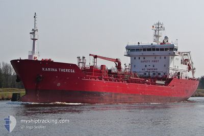
KARINA THERESA
Oil/Chemical Tanker
Current Trip
| Time Travelled | 23 h, 6 mins |
|---|---|
| Remaining Time | 2 days |
| Distance Travelled | 239.03 nm |
| Remaining Distance | 435.96 nm |
| AVG Speed | 11.1 Knopen |
| MAX Speed | 13.3 Knopen |
| AVG Wind | 14.7 knots |
| MAX Wind | 27 knots |
| MIN Temp | -0.2°C / 31.64°F |
| MAX Temp | 9°C / 48.2°F |
| Diepgang | 6.3 M |
| Positie ontvangen | 21 m geleden |
Current Position
| Lengtegraad | --- |
|---|---|
| Breedtegraat | --- |
| Status | Under way using engine |
| Snelheid | 9.2 Knopen |
| Koers | 181.7° |
| Gebied | Celtic Sea |
| Station | T-AIS |
| Positie ontvangen | 21 m geleden |
Info
Information
The current position of KARINA THERESA is in Celtic Sea with coordinates 50.95960° / -6.02144° as reported on 2025-02-17 23:32 by AIS to our vessel tracker app. The vessel's current speed is 9.2 Knopen and is heading at the port of ANTWERP. The estimated time of arrival as calculated by MyShipTracking vessel tracking app is 2025-02-20 02:07 LT
The vessel KARINA THERESA (IMO: 9428451, MMSI: 220648000) is a Oil/Chemical Tanker that was built in 2009 ( 16 Jaar oud ). It's sailing under the flag of [DK] Denmark.
In this page you can find informations about the vessels current position, last detected port calls, and current voyage information. If the vessels is not in coverage by AIS you will find the latest position.
The current position of KARINA THERESA is detected by our AIS receivers and we are not responsible for the reliability of the data. The last position was recorded while the vessel was in Coverage by the Ais receivers of our vessel tracking app.
The current draught of KARINA THERESA as reported by AIS is 6.3 meters
Weather
| Temperature | 9°C / 48.2°F |
|---|---|
| Wind Speed | 24 knots |
| Direction | 137° SE |
| Pressure | 1014.8 hPa |
| Humidity | 88.9 % |
| Cloud Coverage | 100 % |
Featured Company
Last Port Calls
| Port | Arrival | Departure | Time In Port |
|---|---|---|---|
| 2025-02-15 13:23 | 2025-02-17 00:48 | 1 d | |
| 2025-02-13 19:42 | 2025-02-14 09:30 | 13 h | |
| 2025-02-09 15:28 | 2025-02-10 18:28 | 1 d | |
| 2025-02-07 13:58 | 2025-02-08 12:23 | 22 h | |
| 2025-02-04 23:45 | 2025-02-06 11:34 | 1 d | |
| 2025-01-29 17:23 | 2025-01-30 19:58 | 1 d | |
| 2025-01-25 00:19 | 2025-01-26 04:31 | 1 d | |
| 2025-01-21 01:03 | 2025-01-22 08:28 | 1 d | |
| 2025-01-15 03:47 | 2025-01-17 05:44 | 2 d | |
| 2025-01-13 04:06 | 2025-01-13 17:00 | 12 h |
Last Trips
| Origin | Departure | Destination | Arrival | Distance | |
|---|---|---|---|---|---|
| 2025-02-14 09:30 | 2025-02-15 13:23 | 297.49 nm | |||
| 2025-02-10 18:28 | 2025-02-13 19:42 | 615.48 nm | |||
| 2025-02-08 12:23 | 2025-02-09 15:28 | 206.53 nm | |||
| 2025-02-06 11:34 | 2025-02-07 13:58 | 204.79 nm | |||
| 2025-01-30 19:58 | 2025-02-04 23:45 | 58.24 nm | |||
| 2025-01-26 04:31 | 2025-01-29 17:23 | 496.04 nm | |||
| 2025-01-22 08:28 | 2025-01-25 00:19 | 539.07 nm | |||
| 2025-01-17 05:44 | 2025-01-21 01:03 | 935.53 nm | |||
| 2025-01-13 17:00 | 2025-01-15 03:47 | 228.13 nm | |||
| 2025-01-13 03:45 | 2025-01-13 04:06 | 0.41 nm |
Events
| Tijd | Evenement | Details | Positie / Bestemming | Info |
|---|---|---|---|---|
| 2025-02-17 23:39 | Status Changed | Default Under way using engine |
50.93980 / -6.02269
BE ANR
|
Snelheid: 9.2 kn Koers: 181.7° |
| 2025-02-17 23:32 | Status Changed | Under way using engine Default |
50.95960 / -6.02144
BE ANR
|
Snelheid: 9.1 kn Koers: 185° |
| 2025-02-17 23:23 | Binnenbereik |
50.95960 / -6.02144
Celtic Sea
BE ANR
|
Snelheid: 9.2 kn Koers: 181.7° |
|
| 2025-02-17 17:50 | Status Changed | Default Under way using engine |
51.83189 / -5.91089
BE ANR
|
Snelheid: 10.9 kn Koers: 195.3° |
| 2025-02-17 17:37 | Wijzig zee gebeid | United Kingdom part of the Celtic Sea United Kingdom part of the Irish Sea and St. George's Channel |
51.86795 / -5.89358
Celtic Sea
BE ANR
|
Snelheid: 10.9 kn Koers: 195.3° |
| 2025-02-17 17:37 | Status Changed | Under way using engine Default |
51.86795 / -5.89358
BE ANR
|
Snelheid: 10.6 kn Koers: 195° |
| 2025-02-17 17:37 | Buitenbereik |
51.86795 / -5.89358
Celtic Sea
BE ANR
|
Snelheid: 10.9 kn Koers: 195.3° |
|
| 2025-02-17 17:35 | Binnenbereik |
51.86795 / -5.89358
Celtic Sea
BE ANR
|
Snelheid: 10.9 kn Koers: 195.3° |
|
| 2025-02-17 12:23 | Status Changed | Default Under way using engine |
52.76484 / -5.34513
BE ANR
|
Snelheid: 8.3 kn Koers: 202.3° |
| 2025-02-17 12:17 | Buitenbereik |
52.77885 / -5.33560
Irish Sea and St. George's Channel
BE ANR
|
Snelheid: 8.3 kn Koers: 202.3° |