
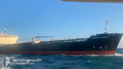
JOHNNY RANGER
Oil/Chemical Tanker
Current Trip
RIOGRANDE
| Time Travelled | 21 days |
|---|---|
| Remaining Time | --- |
| Distance Travelled | 4452.23 nm |
| Remaining Distance | --- |
| AVG Speed | 11.9 Knopen |
| MAX Speed | 15.3 Knopen |
| AVG Wind | 11.6 knots |
| MAX Wind | 31.7 knots |
| MIN Temp | 14.7°C / 58.46°F |
| MAX Temp | 25.3°C / 77.54°F |
| Diepgang | 10 M |
| Positie ontvangen | 2 h, 58 m geleden |
Current Position
| Lengtegraad | 19.03117° |
|---|---|
| Breedtegraat | -34.98150° |
| Status | Under way using engine |
| Snelheid | 12.4 Knopen |
| Koers | 100° |
| Gebied | South Atlantic Ocean |
| Station | T-AIS |
| Positie ontvangen | 2 h, 58 m geleden |
Info
Information
The current position of JOHNNY RANGER is in South Atlantic Ocean with coordinates -34.98150° / 19.03117° as reported on 2024-05-11 13:52 by AIS to our vessel tracker app. The vessel's current speed is 12.4 Knopen
The vessel JOHNNY RANGER (IMO: 9388209, MMSI: 636021509) is a Oil/Chemical Tanker that was built in 2008 ( 16 Jaar oud ). It's sailing under the flag of [LR] Liberia.
In this page you can find informations about the vessels current position, last detected port calls, and current voyage information. If the vessels is not in coverage by AIS you will find the latest position.
The current position of JOHNNY RANGER is detected by our AIS receivers and we are not responsible for the reliability of the data. The last position was recorded while the vessel was in Coverage by the Ais receivers of our vessel tracking app.
The current draught of JOHNNY RANGER as reported by AIS is 10 meters
Weather
| Temperature | 16.9°C / 62.42°F |
|---|---|
| Wind Speed | 10 knots |
| Direction | 241° WSW |
| Pressure | 1022.5 hPa |
| Humidity | 66.6 % |
| Cloud Coverage | 42 % |
Featured Company
Last Port Calls
| Port | Arrival | Departure | Time In Port |
|---|---|---|---|
| 2024-04-04 03:04 | 2024-04-20 00:37 | 15 d | |
| 2024-04-02 09:05 | 2024-04-03 22:37 | 1 d | |
| 2024-03-03 08:01 | 2024-03-04 19:10 | 1 d | |
| 2024-03-03 07:31 | 2024-03-03 07:49 | 17 m |
Most Visited Ports (Last year)
| Port | Arrivals | |
|---|---|---|
| 4 | ||
| 2 | ||
| 2 | ||
| 2 | ||
| 1 | ||
| 1 |
Last Trips
| Origin | Departure | Destination | Arrival | Distance | |
|---|---|---|---|---|---|
| 2024-04-03 19:37 | 2024-04-04 00:04 | 44.81 nm | |||
| 2024-03-04 22:10 | 2024-04-02 06:05 | 7977.91 nm | |||
| 2024-03-03 10:49 | 2024-03-03 11:01 | 0.53 nm | |||
| 2024-02-29 13:20 | 2024-03-03 10:31 | 792.19 nm |
Events
| Tijd | Evenement | Details | Positie / Bestemming | Info |
|---|---|---|---|---|
| 2024-05-11 13:58 | Status Changed | Default Under way using engine |
-34.98483 / 19.05650
RIOGRANDE
|
Snelheid: 12.4 kn Koers: 100° |
| 2024-05-11 13:52 | Buitenbereik |
-34.98150 / 19.03117
South Atlantic Ocean
|
Snelheid: 12.4 kn Koers: 100° |
|
| 2024-05-11 13:29 | Status Changed | Under way using engine Default |
-34.96883 / 18.93717
RIOGRANDE
|
Snelheid: 12.7 kn Koers: 102° |
| 2024-05-11 13:27 | Binnenbereik |
-34.96883 / 18.93717
South Atlantic Ocean
|
Snelheid: 12.9 kn Koers: 100° |
|
| 2024-05-11 11:55 | Status Changed | Default Under way using engine |
-34.90033 / 18.54583
RIOGRANDE
|
Snelheid: 12.7 kn Koers: 105° |
| 2024-05-11 11:43 | Buitenbereik |
-34.88983 / 18.49550
South Atlantic Ocean
|
Snelheid: 12.7 kn Koers: 105° |
|
| 2024-05-11 10:58 | Wijzig zee gebeid | South African part of the South Atlantic Ocean Brazilian part of the South Atlantic Ocean |
-34.84283 / 18.32067
South Atlantic Ocean
|
Snelheid: 12 kn Koers: 109° |
| 2024-05-11 10:57 | Status Changed | Under way using engine Default |
-34.84117 / 18.31500
RIOGRANDE
|
Snelheid: 11.8 kn Koers: 109° |
| 2024-05-11 10:55 | Binnenbereik |
-34.84283 / 18.32067
South Atlantic Ocean
|
Snelheid: 12 kn Koers: 109° |