
INANDI
General Cargo
Current Trip
| Trip Time | 4 days |
|---|---|
| Trip Distance | 551.88 nm |
| AVG Speed | 7.6 Knopen |
| MAX Speed | 10.3 Knopen |
| Diepgang | 6 M |
| AVG Wind | 5.1 knots |
| MAX Wind | 16 knots |
| MIN Temp | -0.3°C / 31.46°F |
| MAX Temp | 9.9°C / 49.82°F |
| Positie ontvangen | 1 d geleden |
Current Position
| Lengtegraad | --- |
|---|---|
| Breedtegraat | --- |
| Status | Under way using engine |
| Snelheid | 7.3 Knopen |
| Koers | 325.4° |
| Gebied | Black Sea |
| Station | T-AIS |
| Positie ontvangen | 1 d geleden |
Info
Information
The current position of INANDI is in Black Sea with coordinates 41.48254° / 29.07625° as reported on 2025-02-15 13:20 by AIS to our vessel tracker app. The vessel's current speed is 7.3 Knopen and is currently inside the port of VARNA.
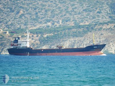
The vessel INANDI (IMO: 8332100, MMSI: 353920000) is a General Cargo that was built in 1984 ( 41 Jaar oud ). It's sailing under the flag of [PA] Panama.
In this page you can find informations about the vessels current position, last detected port calls, and current voyage information. If the vessels is not in coverage by AIS you will find the latest position.
The current position of INANDI is detected by our AIS receivers and we are not responsible for the reliability of the data. The last position was recorded while the vessel was in Coverage by the Ais receivers of our vessel tracking app.
The current draught of INANDI as reported by AIS is 6 meters
Weather
| Temperature | 1.1°C / 33.98°F |
|---|---|
| Wind Speed | 12 knots |
| Direction | 61° ENE |
| Pressure | 1021.1 hPa |
| Humidity | 98.8 % |
| Cloud Coverage | 100 % |
Featured Company
Last Port Calls
| Port | Arrival | Departure | Time In Port |
|---|---|---|---|
| 2025-02-16 07:01 | |||
| 2025-02-10 09:29 | 2025-02-11 09:36 | 1 d | |
| 2025-02-04 22:45 | |||
| 2025-01-27 16:57 | 2025-01-28 17:01 | 1 d | |
| 2025-01-20 06:21 | 2025-01-21 18:11 | 1 d | |
| 2025-01-12 06:13 | 2025-01-14 16:32 | 2 d | |
| 2025-01-03 15:27 | 2025-01-05 07:35 | 1 d | |
| 2024-12-16 13:11 | 2024-12-17 04:53 | 15 h | |
| 2024-12-13 09:36 | |||
| 2024-12-08 07:57 | 2024-12-09 09:35 | 1 d |
Last Trips
| Origin | Departure | Destination | Arrival | Distance | |
|---|---|---|---|---|---|
| 2025-02-11 11:36 | 2025-02-16 09:01 | 551.88 nm | |||
| 2025-02-05 00:45 | 2025-02-10 11:29 | 558.66 nm | |||
| 2025-01-21 20:11 | 2025-01-27 18:57 | 853.68 nm | |||
| 2025-01-14 18:32 | 2025-01-20 08:21 | 683.85 nm | |||
| 2025-01-05 09:35 | 2025-01-12 08:13 | 565.34 nm | |||
| 2024-12-17 06:53 | 2025-01-03 17:27 | 774.25 nm | |||
| 2024-12-13 11:36 | 2024-12-16 15:11 | 538.64 nm | |||
| 2024-11-28 13:50 | 2024-12-08 09:57 | 636.08 nm |
Events
| Tijd | Evenement | Details | Positie / Bestemming | Info |
|---|---|---|---|---|
| 2025-02-16 07:45 | Stop beweging |
43.20020 / 27.89007
[BG] VARNA
|
Snelheid: Koers: 131° |
|
| 2025-02-16 07:01 | Aankomsthaven |
|
43.18438 / 27.91861
[BG] VARNA
|
Snelheid: 7.9 kn Koers: 263° |
| 2025-02-15 13:22 | Status Changed | Default Under way using engine |
41.48473 / 29.07413
BG VAR
|
Snelheid: 7.3 kn Koers: 325.4° |
| 2025-02-15 13:20 | Buitenbereik |
41.48254 / 29.07625
Black Sea
BG VAR
|
Snelheid: 7.3 kn Koers: 325.4° |
|
| 2025-02-15 11:11 | Wijzig zee gebeid | Turkish part of the Black Sea Turkish part of the Sea of Marmara |
41.23346 / 29.14018
Black Sea
BG VAR
|
Snelheid: 8.5 kn Koers: 28.4° |
| 2025-02-15 07:23 | Start beweging | 1.62 nm, South West of KARTAL |
40.86807 / 29.17307
BG VAR
|
Snelheid: 3.4 kn Koers: 301° |
| 2025-02-15 07:07 | Status Changed | Under way using engine At anchor |
40.87044 / 29.17505
BG VAR
|
Snelheid: Koers: 113° |
| 2025-02-15 06:34 | Status Changed | At anchor Default |
40.87052 / 29.17508
BG VAR
|
Snelheid: Koers: 121° |
| 2025-02-15 06:28 | Status Changed | Default At anchor |
40.87057 / 29.17502
BG VAR
|
Snelheid: Koers: 121° |
| 2025-02-15 05:07 | Status Changed | At anchor Default |
40.87059 / 29.17517
BG VAR
|
Snelheid: Koers: 139° |