
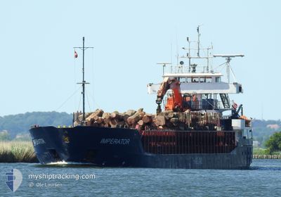
IMPERATOR
General Cargo
Current Trip
SNEKKEVIK
| Time Travelled | 1 day |
|---|---|
| Remaining Time | --- |
| Distance Travelled | 255.95 nm |
| Remaining Distance | --- |
| AVG Speed | 9.1 Knopen |
| MAX Speed | 10.5 Knopen |
| AVG Wind | 19.3 knots |
| MAX Wind | 25 knots |
| MIN Temp | 6.3°C / 43.34°F |
| MAX Temp | 8.2°C / 46.76°F |
| Diepgang | 3.8 M |
| Positie ontvangen | 5 m geleden |
Current Position
| Lengtegraad | --- |
|---|---|
| Breedtegraat | --- |
| Status | Moored |
| Snelheid | |
| Koers | 234° |
| Gebied | Skaggerak |
| Station | T-AIS |
| Positie ontvangen | 5 m geleden |
Info
Information
The current position of IMPERATOR is in Skaggerak with coordinates 58.86147° / 9.30241° as reported on 2025-12-16 09:11 by AIS to our vessel tracker app. The vessel's current speed is 0 Knopen
The vessel IMPERATOR (IMO: 9014690, MMSI: 257141000) is a General Cargo that was built in 1992 ( 33 Jaar oud ). It's sailing under the flag of [NO] Norway.
In this page you can find informations about the vessels current position, last detected port calls, and current voyage information. If the vessels is not in coverage by AIS you will find the latest position.
The current position of IMPERATOR is detected by our AIS receivers and we are not responsible for the reliability of the data. The last position was recorded while the vessel was in Coverage by the Ais receivers of our vessel tracking app.
The current draught of IMPERATOR as reported by AIS is 3.8 meters
Weather
| Temperature | 7.9°C / 46.22°F |
|---|---|
| Wind Speed | 14 knots |
| Direction | 212° SSW |
| Pressure | 1008.5 hPa |
| Humidity | 91.9 % |
| Cloud Coverage | 100 % |
Featured Company
Last Port Calls
| Port | Arrival | Departure | Time In Port |
|---|---|---|---|
| 2025-12-14 12:13 | 2025-12-15 02:06 | 13 h | |
| 2025-12-13 17:36 | 2025-12-14 01:43 | 8 h | |
| 2025-12-12 19:04 | 2025-12-13 11:57 | 16 h | |
| 2025-12-11 09:21 | 2025-12-11 21:29 | 12 h | |
| 2025-12-10 08:50 | 2025-12-11 00:00 | 15 h | |
| 2025-12-09 03:46 | 2025-12-09 19:16 | 15 h | |
| 2025-12-06 23:37 | 2025-12-07 09:25 | 9 h | |
| 2025-12-06 05:46 | 2025-12-06 16:09 | 10 h | |
| 2025-12-03 09:36 | 2025-12-03 22:39 | 13 h | |
| 2025-12-02 11:21 | 2025-12-02 23:48 | 12 h |
Last Trips
| Origin | Departure | Destination | Arrival | Distance | |
|---|---|---|---|---|---|
| 2025-12-14 01:43 | 2025-12-14 12:13 | 96.11 nm | |||
| 2025-12-13 11:57 | 2025-12-13 17:36 | 53.56 nm | |||
| 2025-12-11 21:29 | 2025-12-12 19:04 | 214.79 nm | |||
| 2025-12-11 00:00 | 2025-12-11 09:21 | 85.65 nm | |||
| 2025-12-09 19:16 | 2025-12-10 08:50 | 139.29 nm | |||
| 2025-12-07 09:25 | 2025-12-09 03:46 | 335.60 nm | |||
| 2025-12-06 16:09 | 2025-12-06 23:37 | 67.05 nm | |||
| 2025-12-03 22:39 | 2025-12-06 05:46 | 308.13 nm | |||
| 2025-12-02 23:48 | 2025-12-03 09:36 | 86.48 nm | |||
| 2025-12-02 00:07 | 2025-12-02 11:21 | 100.19 nm |
Events
| Tijd | Evenement | Details | Positie / Bestemming | Info |
|---|---|---|---|---|
| 2025-12-16 05:14 | Status Changed | Moored Under way using engine |
58.86138 / 9.30221
SNEKKEVIK
|
Snelheid: Koers: 234° |
| 2025-12-16 05:03 | Stop beweging | 3.63 nm, West of KRAGERO |
58.86144 / 9.30311
SNEKKEVIK
|
Snelheid: Koers: 243° |
| 2025-12-16 00:18 | Wijzig zee gebeid | Norwegian part of the Skaggerak Swedish part of the Skaggerak |
58.40639 / 10.08208
Skaggerak
SNEKKEVIK
|
Snelheid: 9.6 kn Koers: 310.3° |
| 2025-12-15 22:22 | Wijzig zee gebeid | Swedish part of the Skaggerak Danish part of the Skaggerak |
58.16466 / 10.42790
Skaggerak
SNEKKEVIK
|
Snelheid: 9.6 kn Koers: 321.9° |
| 2025-12-15 19:20 | Wijzig zee gebeid | Danish part of the Skaggerak Danish part of the Kattegat |
57.80490 / 10.96572
Skaggerak
SNEKKEVIK
|
Snelheid: 9.9 kn Koers: 316.6° |
| 2025-12-15 18:15 | Wijzig zee gebeid | Danish part of the Kattegat Swedish part of the Kattegat |
57.67826 / 11.17945
Kattegat
SNEKKEVIK
|
Snelheid: 9.4 kn Koers: 321.5° |
| 2025-12-15 11:10 | Status Changed | Under way using engine Default |
56.73734 / 12.18367
SNEKKEVIK
|
Snelheid: 10 kn Koers: 335° |
| 2025-12-15 10:58 | Binnenbereik |
56.73906 / 12.18294
Kattegat
SNEKKEVIK
|
Snelheid: 9.7 kn Koers: 344.1° |
|
| 2025-12-15 08:34 | Status Changed | Default Under way using engine |
56.33968 / 12.36838
SNEKKEVIK
|
Snelheid: 9.8 kn Koers: 348.2° |
| 2025-12-15 08:26 | Buitenbereik |
56.31927 / 12.37711
Kattegat
SNEKKEVIK
|
Snelheid: 9.8 kn Koers: 348.2° |