
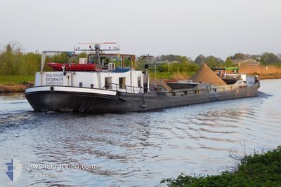
NOOIT GEDACHT
Cargo
Current Trip
HAGHORST
| Time Travelled | 1 day |
|---|---|
| Remaining Time | --- |
| Distance Travelled | 26.52 nm |
| Remaining Distance | --- |
| AVG Speed | 4 Knopen |
| MAX Speed | 6.2 Knopen |
| AVG Wind | 8.9 knots |
| MAX Wind | 10.8 knots |
| MIN Temp | 7.6°C / 45.68°F |
| MAX Temp | 14.2°C / 57.56°F |
| Diepgang | 0.1 M |
| Positie ontvangen | 14 h, 49 m geleden |
Current Position
| Lengtegraad | 5.56372° |
|---|---|
| Breedtegraat | 51.51181° |
| Status | Under way using engine |
| Snelheid | 2.9 Knopen |
| Koers | --- |
| Gebied | North Sea |
| Station | T-AIS |
| Positie ontvangen | 14 h, 49 m geleden |
Info
Information
The current position of NOOIT GEDACHT is in North Sea with coordinates 51.51181° / 5.56372° as reported on 2024-05-04 05:37 by AIS to our vessel tracker app. The vessel's current speed is 2.9 Knopen
The vessel NOOIT GEDACHT (MMSI: 244710476) is a Cargo It's sailing under the flag of [NL] Netherlands.
In this page you can find informations about the vessels current position, last detected port calls, and current voyage information. If the vessels is not in coverage by AIS you will find the latest position.
The current position of NOOIT GEDACHT is detected by our AIS receivers and we are not responsible for the reliability of the data. The last position was recorded while the vessel was in Coverage by the Ais receivers of our vessel tracking app.
The current draught of NOOIT GEDACHT as reported by AIS is 0.1 meters
Weather
| Temperature | 8.6°C / 47.48°F |
|---|---|
| Wind Speed | 5 knots |
| Direction | 181° S |
| Pressure | 1014.6 hPa |
| Humidity | 88.1 % |
| Cloud Coverage | 86 % |
Featured Company
Last Port Calls
| Port | Arrival | Departure | Time In Port |
|---|---|---|---|
| 2024-05-03 11:28 | 2024-05-03 13:22 | 1 h | |
| 2024-04-22 15:51 | 2024-04-23 05:02 | 13 h | |
| 2024-04-19 17:06 | 2024-04-19 17:21 | 15 m | |
| 2024-04-19 08:55 | 2024-04-19 12:02 | 3 h | |
| 2024-04-17 21:09 | 2024-04-18 06:29 | 9 h | |
| 2024-04-12 09:43 | 2024-04-15 04:32 | 2 d | |
| 2024-04-08 17:31 | 2024-04-08 17:51 | 19 m | |
| 2024-04-05 15:09 | 2024-04-08 07:30 | 2 d | |
| 2024-04-05 07:17 | 2024-04-05 09:51 | 2 h | |
| 2024-04-04 11:07 | 2024-04-04 15:56 | 4 h |
Most Visited Ports (Last year)
| Port | Arrivals | |
|---|---|---|
| 16 | ||
| 5 | ||
| 4 | ||
| 3 | ||
| 3 | ||
| 3 |
Last Trips
| Origin | Departure | Destination | Arrival | Distance | |
|---|---|---|---|---|---|
| 2024-04-23 07:02 | 2024-05-03 13:28 | 107.01 nm | |||
| 2024-04-19 19:21 | 2024-04-22 17:51 | 47.41 nm | |||
| 2024-04-19 14:02 | 2024-04-19 19:06 | 1.56 nm | |||
| 2024-04-18 08:29 | 2024-04-19 10:55 | 57.34 nm | |||
| 2024-04-15 06:32 | 2024-04-17 23:09 | 179.04 nm | |||
| 2024-04-08 19:51 | 2024-04-12 11:43 | 140.48 nm | |||
| 2024-04-08 09:30 | 2024-04-08 19:31 | 48.83 nm | |||
| 2024-04-05 11:51 | 2024-04-05 17:09 | 32.61 nm | |||
| 2024-04-04 17:56 | 2024-04-05 09:17 | 32.67 nm | |||
| 2024-04-04 07:34 | 2024-04-04 13:07 | 34.95 nm |
Events
| Tijd | Evenement | Details | Positie / Bestemming | Info |
|---|---|---|---|---|
| 2024-05-04 05:37 | Buitenbereik |
51.51181 / 5.56372
North Sea
|
Snelheid: 2.9 kn Koers: 262.1° |
|
| 2024-05-04 04:29 | Binnenbereik |
51.50267 / 5.67249
North Sea
|
Snelheid: 5.8 kn Koers: 328.5° |
|
| 2024-05-03 19:17 | Buitenbereik |
51.44360 / 5.69221
North Sea
|
Snelheid: 7.2 kn Koers: 356.6° |
|
| 2024-05-03 19:10 | Start beweging | 3.02 nm, South East of HELMOND |
51.43138 / 5.69618
HAGHORST
|
Snelheid: 6.5 kn Koers: 347.8° |
| 2024-05-03 18:55 | Stop beweging | 3.92 nm, South East of HELMOND |
51.41610 / 5.70135
HAGHORST
|
Snelheid: Koers: 511° |
| 2024-05-03 17:31 | Start beweging | 8.08 nm, South East of HELMOND |
51.35165 / 5.74307
HAGHORST
|
Snelheid: 3.6 kn Koers: 355.6° |
| 2024-05-03 17:20 | Stop beweging | 8.19 nm, South East of HELMOND |
51.34985 / 5.74338
HAGHORST
|
Snelheid: 0.3 kn Koers: 511° |
| 2024-05-03 16:57 | Start beweging | 9.22 nm, South of HELMOND |
51.33191 / 5.74639
HAGHORST
|
Snelheid: 3.2 kn Koers: 354.3° |
| 2024-05-03 16:43 | Stop beweging | 9.33 nm, South of HELMOND |
51.33001 / 5.74669
HAGHORST
|
Snelheid: 0.1 kn Koers: 511° |
| 2024-05-03 13:51 | Binnenbereik |
51.17158 / 5.87125
North Sea
|
Snelheid: 4.7 kn Koers: 289.4° |