
HARMONIC
Tanker
Current Trip
RO CND
| Time Travelled | --- |
|---|---|
| Remaining Time | --- |
| Distance Travelled | --- |
| Remaining Distance | --- |
| AVG Speed | --- |
| MAX Speed | --- |
| AVG Wind | --- |
| MAX Wind | --- |
| MIN Temp | --- |
| MAX Temp | --- |
| Diepgang | 9 M |
| Positie ontvangen | 2 h, 27 m geleden |
Current Position
| Lengtegraad | 28.81554° |
|---|---|
| Breedtegraat | 44.15202° |
| Status | At anchor |
| Snelheid | |
| Koers | 189° |
| Gebied | Black Sea |
| Station | T-AIS |
| Positie ontvangen | 2 h, 27 m geleden |
Info
Information
The current position of HARMONIC is in Black Sea with coordinates 44.15202° / 28.81554° as reported on 2024-06-10 08:28 by AIS to our vessel tracker app. The vessel's current speed is 0 Knopen
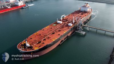
The vessel HARMONIC (IMO: 9819868, MMSI: 241665000) is a Tanker It's sailing under the flag of [GR] Greece.
In this page you can find informations about the vessels current position, last detected port calls, and current voyage information. If the vessels is not in coverage by AIS you will find the latest position.
The current position of HARMONIC is detected by our AIS receivers and we are not responsible for the reliability of the data. The last position was recorded while the vessel was in Coverage by the Ais receivers of our vessel tracking app.
The current draught of HARMONIC as reported by AIS is 9 meters
Weather
| Temperature | 22.7°C / 72.86°F |
|---|---|
| Wind Speed | 15 knots |
| Direction | 169° S |
| Pressure | 1010.7 hPa |
| Humidity | 72.7 % |
| Cloud Coverage | 74 % |
Featured Company
Most Visited Ports (Last year)
| Port | Arrivals | |
|---|---|---|
| 8 | ||
| 2 | ||
| 1 | ||
| 1 | ||
| 1 | ||
| 1 |
Last Trips
| Origin | Departure | Destination | Arrival | Distance | |
|---|---|---|---|---|---|
| 2024-04-23 08:34 | 2024-05-31 06:18 | 8395.74 nm | |||
| 2024-03-07 11:37 | 2024-04-22 11:14 | 9791.74 nm |
Events
| Tijd | Evenement | Details | Positie / Bestemming | Info |
|---|---|---|---|---|
| 2024-06-10 08:28 | Buitenbereik |
44.15202 / 28.81554
Black Sea
|
Snelheid: Koers: 189° |
|
| 2024-06-10 02:23 | Binnenbereik |
44.15210 / 28.81532
Black Sea
|
Snelheid: Koers: 185° |
|
| 2024-06-10 01:03 | Buitenbereik |
44.15215 / 28.81551
Black Sea
|
Snelheid: Koers: 187° |
|
| 2024-06-09 23:46 | Binnenbereik |
44.15230 / 28.81543
Black Sea
|
Snelheid: Koers: 185° |
|
| 2024-06-09 21:05 | Buitenbereik |
44.15199 / 28.81580
Black Sea
|
Snelheid: 0.2 kn Koers: 190° |
|
| 2024-06-09 20:11 | Binnenbereik |
44.15197 / 28.81599
Black Sea
|
Snelheid: Koers: 201° |
|
| 2024-06-09 18:25 | Buitenbereik |
44.15202 / 28.81607
Black Sea
|
Snelheid: 0.1 kn Koers: 201° |
|
| 2024-06-09 06:58 | Binnenbereik |
44.15193 / 28.81394
Black Sea
|
Snelheid: Koers: 159° |
|
| 2024-06-09 05:43 | Buitenbereik |
44.15186 / 28.81423
Black Sea
|
Snelheid: Koers: 151° |
|
| 2024-06-09 04:56 | Stop beweging | 6.35 nm, East of CONSTANTA |
44.15128 / 28.81304
RO CND
|
Snelheid: Koers: 147° |