
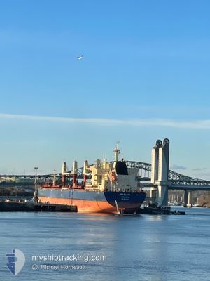
GW ELENI
Cargo
Current Trip
| Trip Time | 2 days |
|---|---|
| Trip Distance | 201.55 nm |
| AVG Speed | 11.8 Knopen |
| MAX Speed | 13.1 Knopen |
| Diepgang | 8.6 M |
| AVG Wind | 8.1 knots |
| MAX Wind | 13.1 knots |
| MIN Temp | 14°C / 57.2°F |
| MAX Temp | 24.1°C / 75.38°F |
| Positie ontvangen | 5 d geleden |
Current Position
| Lengtegraad | 129.70061° |
|---|---|
| Breedtegraat | 35.65914° |
| Status | Under way using engine |
| Snelheid | 12.5 Knopen |
| Koers | 7° |
| Gebied | Japan Sea |
| Station | T-AIS |
| Positie ontvangen | 5 d geleden |
Info
Information
The current position of GW ELENI is in Japan Sea with coordinates 35.65914° / 129.70061° as reported on 2024-05-18 15:44 by AIS to our vessel tracker app. The vessel's current speed is 12.5 Knopen and is currently inside the port of POHANG.
The vessel GW ELENI (IMO: 9874648, MMSI: 636092960) is a Cargo It's sailing under the flag of [LR] Liberia.
In this page you can find informations about the vessels current position, last detected port calls, and current voyage information. If the vessels is not in coverage by AIS you will find the latest position.
The current position of GW ELENI is detected by our AIS receivers and we are not responsible for the reliability of the data. The last position was recorded while the vessel was in Coverage by the Ais receivers of our vessel tracking app.
The current draught of GW ELENI as reported by AIS is 8.6 meters
Weather
| Temperature | 19.1°C / 66.38°F |
|---|---|
| Wind Speed | 7 knots |
| Direction | 241° WSW |
| Pressure | 1008.5 hPa |
| Humidity | 67.9 % |
| Cloud Coverage | 22 % |
Featured Company
Most Visited Ports (Last year)
| Port | Arrivals | |
|---|---|---|
| 2 | ||
| 2 | ||
| 1 | ||
| 1 | ||
| 1 | ||
| 1 |
Events
| Tijd | Evenement | Details | Positie / Bestemming | Info |
|---|---|---|---|---|
| 2024-05-20 10:58 | Stop beweging |
36.01514 / 129.39416
[KR] POHANG
|
Snelheid: Koers: 204° |
|
| 2024-05-20 10:15 | Aankomsthaven |
|
36.02423 / 129.41568
[KR] POHANG
|
Snelheid: 11.2 kn Koers: 229° |
| 2024-05-20 09:30 | Start beweging | 6.42 nm, North East of POHANG |
36.10054 / 129.49986
KRKPO
|
Snelheid: 10.6 kn Koers: 191° |
| 2024-05-18 20:01 | Stop beweging | 6.88 nm, North East of POHANG |
36.12166 / 129.47971
KRKPO
|
Snelheid: 0.3 kn Koers: 200° |
| 2024-05-18 15:47 | Status Changed | Default Under way using engine |
35.66954 / 129.70151
KRKPO
|
Snelheid: 12.5 kn Koers: 7° |
| 2024-05-18 15:44 | Buitenbereik |
35.65914 / 129.70061
Japan Sea
KRKPO
|
Snelheid: 12.5 kn Koers: 7° |
|
| 2024-05-18 07:47 | Draught Changed | 8.6 7.4 |
34.46767 / 128.55814
KRKPO
|
Snelheid: 12 kn Koers: 72.5° |
| 2024-05-18 07:47 | Destination Changed | KRKPO KRKAN |
34.46767 / 128.55814
KRKPO
|
Snelheid: 12 kn Koers: 72.5° |
| 2024-05-18 07:47 | ETA Changed | 2024/05/19 05:00 2024/05/14 06:00 |
34.46767 / 128.55814
KRKPO
|
Snelheid: 12 kn Koers: 72.5° |
| 2024-05-18 07:29 | Status Changed | Under way using engine Default |
34.45796 / 128.48742
KRKAN
|
Snelheid: 12.3 kn Koers: 83° |