

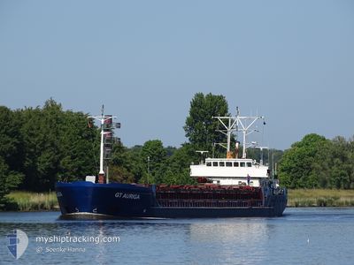
GT AURIGA
General Cargo

Current Trip
FRLLG
| Time Travelled | 6 days |
|---|---|
| Remaining Time | --- |
| Distance Travelled | 1201.63 nm |
| Remaining Distance | --- |
| AVG Speed | 7 Knopen |
| MAX Speed | 12.3 Knopen |
| AVG Wind | 10.8 knots |
| MAX Wind | 22.8 knots |
| MIN Temp | -4.5°C / 23.9°F |
| MAX Temp | 9°C / 48.2°F |
| Diepgang | 5.3 M |
| Positie ontvangen | 1 m geleden |
Current Position
| Lengtegraad | --- |
|---|---|
| Breedtegraat | --- |
| Status | Under way using engine |
| Snelheid | 9.5 Knopen |
| Koers | 231.6° |
| Gebied | North Sea |
| Station | T-AIS |
| Positie ontvangen | 1 m geleden |
Information
The current position of GT AURIGA is in North Sea with coordinates 51.03000° / 1.36842° as reported on 2025-03-28 04:28 by AIS to our vessel tracker app. The vessel's current speed is 9.5 Knopen
The vessel GT AURIGA (IMO: 9041318, MMSI: 304010285) is a General Cargo that was built in 1993 ( 32 Jaar oud ). It's sailing under the flag of [AG] Antigua Barbuda.
In this page you can find informations about the vessels current position, last detected port calls, and current voyage information. If the vessels is not in coverage by AIS you will find the latest position.
The current position of GT AURIGA is detected by our AIS receivers and we are not responsible for the reliability of the data. The last position was recorded while the vessel was in Coverage by the Ais receivers of our vessel tracking app.
The current draught of GT AURIGA as reported by AIS is 5.3 meters
Weather
| Temperature | 8°C / 46.4°F |
|---|---|
| Wind Speed | 15 knots |
| Direction | 243° WSW |
| Pressure | 1013.7 hPa |
| Humidity | 90.6 % |
| Cloud Coverage | 100 % |


Featured Company
Last Port Calls
| Port | Arrival | Departure | Time In Port |
|---|---|---|---|
| 2025-03-20 18:38 | 2025-03-22 00:54 | 1 d | |
| 2025-03-17 14:10 | 2025-03-18 14:26 | 1 d | |
| 2025-03-09 07:11 | 2025-03-12 11:32 | 3 d | |
| 2025-03-08 09:30 | 2025-03-08 10:13 | 43 m | |
| 2025-03-02 08:36 | 2025-03-06 11:37 | 4 d | |
| 2025-02-16 21:07 | 2025-02-17 23:53 | 1 d | |
| 2025-02-14 07:01 | 2025-02-15 19:49 | 1 d | |
| 2025-02-12 05:06 | 2025-02-13 16:40 | 1 d | |
| 2025-02-05 09:37 | 2025-02-06 04:21 | 18 h | |
| 2025-01-31 20:28 | 2025-02-03 23:12 | 3 d |
Last Trips
| Origin | Departure | Destination | Arrival | Distance | |
|---|---|---|---|---|---|
| 2025-03-18 14:26 | 2025-03-20 18:38 | 430.79 nm | |||
| 2025-03-12 11:32 | 2025-03-17 14:10 | 881.64 nm | |||
| 2025-03-08 10:13 | 2025-03-09 07:11 | 152.14 nm | |||
| 2025-03-06 11:37 | 2025-03-08 09:30 | 358.53 nm | |||
| 2025-02-17 23:53 | 2025-03-02 08:36 | 1214.45 nm | |||
| 2025-02-15 19:49 | 2025-02-16 21:07 | 200.88 nm | |||
| 2025-02-13 16:40 | 2025-02-14 07:01 | 68.18 nm | |||
| 2025-02-06 04:21 | 2025-02-12 05:06 | 1077.44 nm | |||
| 2025-02-03 23:12 | 2025-02-05 09:37 | 325.05 nm | |||
| 2025-01-29 05:01 | 2025-01-31 20:28 | 579.53 nm |
Events
| Tijd | Evenement | Details | Positie / Bestemming | Info |
|---|---|---|---|---|
| 2025-03-28 03:58 | Gevonden in zee | United Kingdom part of the English Channel |
51.07793 / 1.45976
English Channel
FRLLG
|
Snelheid: 9 kn Koers: 229.3° |
| 2025-03-27 21:20 | ETA Changed | 2025/03/29 10:00 2025/03/29 09:00 |
51.66954 / 2.25995
FRLLG
|
Snelheid: 9 kn Koers: 219.1° |
| 2025-03-27 21:08 | ETA Changed | 2025/03/29 09:00 2025/03/29 03:00 |
51.69300 / 2.29113
FRLLG
|
Snelheid: 9.3 kn Koers: 218.8° |
| 2025-03-27 20:59 | Start beweging |
51.71107 / 2.31464
FRLLG
|
Snelheid: 9.6 kn Koers: 219.9° |
|
| 2025-03-27 20:58 | Status Changed | Under way using engine Default |
51.71314 / 2.31736
FRLLG
|
Snelheid: Koers: 0° |
| 2025-03-27 20:58 | Status Changed | Default Under way using engine |
51.71384 / 2.31826
FRLLG
|
Snelheid: 9.7 kn Koers: 219.3° |
| 2025-03-27 20:58 | Stop beweging |
51.71384 / 2.31826
FRLLG
|
Snelheid: Koers: 0° |
|
| 2025-03-27 19:50 | Status Changed | Under way using engine Default |
51.85951 / 2.51253
FRLLG
|
Snelheid: 10.3 kn Koers: 222° |
| 2025-03-27 19:45 | Status Changed | Default Under way using engine |
51.87008 / 2.52776
FRLLG
|
Snelheid: 10.2 kn Koers: 220° |
| 2025-03-27 19:38 | Gevonden in zee | United Kingdom part of the North Sea |
51.88493 / 2.54807
North Sea
FRLLG
|
Snelheid: 10.2 kn Koers: 220° |