
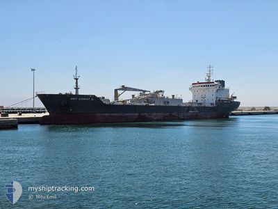
GRIT CEMENT III
Cement Carrier
Current Trip
| Time Travelled | 3 days |
|---|---|
| Remaining Time | 4 days |
| Distance Travelled | 758.00 nm |
| Remaining Distance | 1037.43 nm |
| AVG Speed | 9.5 Knopen |
| MAX Speed | 11.3 Knopen |
| AVG Wind | 17.3 knots |
| MAX Wind | 24.9 knots |
| MIN Temp | 13.9°C / 57.02°F |
| MAX Temp | 21.9°C / 71.42°F |
| Diepgang | 8.9 M |
| Positie ontvangen | 8 m geleden |
Current Position
| Lengtegraad | -9.82456° |
|---|---|
| Breedtegraat | 40.72373° |
| Status | Under way using engine |
| Snelheid | 9 Knopen |
| Koers | 0.7° |
| Gebied | North Atlantic Ocean |
| Station | T-AIS |
| Positie ontvangen | 8 m geleden |
Info
Information
The current position of GRIT CEMENT III is in North Atlantic Ocean with coordinates 40.72373° / -9.82456° as reported on 2024-05-23 23:19 by AIS to our vessel tracker app. The vessel's current speed is 9 Knopen and is heading at the port of IMMINGHAM. The estimated time of arrival as calculated by MyShipTracking vessel tracking app is 2024-05-28 21:46 LT
The vessel GRIT CEMENT III (IMO: 9116515, MMSI: 352003075) is a Cement Carrier that was built in 1996 ( 28 Jaar oud ). It's sailing under the flag of [PA] Panama.
In this page you can find informations about the vessels current position, last detected port calls, and current voyage information. If the vessels is not in coverage by AIS you will find the latest position.
The current position of GRIT CEMENT III is detected by our AIS receivers and we are not responsible for the reliability of the data. The last position was recorded while the vessel was in Coverage by the Ais receivers of our vessel tracking app.
The current draught of GRIT CEMENT III as reported by AIS is 8.9 meters
Weather
| Temperature | 15.5°C / 59.9°F |
|---|---|
| Wind Speed | 22 knots |
| Direction | 354° N |
| Pressure | 1018.1 hPa |
| Humidity | 79.2 % |
| Cloud Coverage | 2 % |
Featured Company
Last Port Calls
| Port | Arrival | Departure | Time In Port |
|---|---|---|---|
| 2024-05-17 09:36 | 2024-05-20 13:44 | 3 d | |
| 2024-05-04 14:14 | |||
| 2024-04-15 17:59 | 2024-04-22 14:30 | 6 d | |
| 2024-04-03 11:37 | 2024-04-08 01:21 | 4 d | |
| 2024-03-21 02:58 | 2024-03-24 12:00 | 3 d | |
| 2024-03-08 15:14 | 2024-03-13 18:50 | 5 d |
Last Trips
| Origin | Departure | Destination | Arrival | Distance | |
|---|---|---|---|---|---|
| 2024-04-22 14:30 | 2024-05-04 14:14 | 1834.93 nm | |||
| 2024-04-08 01:21 | 2024-04-15 17:59 | 1868.65 nm | |||
| 2024-03-24 12:00 | 2024-04-03 11:37 | 2006.85 nm | |||
| 2024-03-13 18:50 | 2024-03-21 02:58 | 1836.27 nm | |||
| 2024-02-19 20:33 | 2024-03-08 15:14 | 2129.36 nm |
Events
| Tijd | Evenement | Details | Positie / Bestemming | Info |
|---|---|---|---|---|
| 2024-05-23 23:18 | Status Changed | Under way using engine Default |
40.72122 / -9.82457
GB IMM
|
Snelheid: 9 kn Koers: 2° |
| 2024-05-23 23:08 | Status Changed | Default Under way using engine |
40.69558 / -9.82616
GB IMM
|
Snelheid: 8.8 kn Koers: 2.6° |
| 2024-05-23 23:04 | Status Changed | Under way using engine Default |
40.68563 / -9.82669
GB IMM
|
Snelheid: 8.8 kn Koers: 1° |
| 2024-05-23 23:02 | Status Changed | Default Under way using engine |
40.68023 / -9.82689
GB IMM
|
Snelheid: 8.9 kn Koers: 3.1° |
| 2024-05-23 22:49 | Status Changed | Under way using engine Default |
40.64911 / -9.82856
GB IMM
|
Snelheid: 8.7 kn Koers: 357° |
| 2024-05-23 22:34 | Status Changed | Default Under way using engine |
40.61206 / -9.82981
GB IMM
|
Snelheid: 9 kn Koers: 1° |
| 2024-05-23 22:26 | Status Changed | Under way using engine Default |
40.59083 / -9.83020
GB IMM
|
Snelheid: 9.3 kn Koers: 359° |
| 2024-05-23 22:26 | Binnenbereik |
40.59326 / -9.83016
North Atlantic Ocean
GB IMM
|
Snelheid: 9 kn Koers: 1° |
|
| 2024-05-23 21:27 | Status Changed | Default Under way using engine |
40.44441 / -9.83374
GB IMM
|
Snelheid: 8.9 kn Koers: 4.6° |
| 2024-05-23 21:21 | Buitenbereik |
40.43187 / -9.83466
North Atlantic Ocean
GB IMM
|
Snelheid: 8.9 kn Koers: 4.6° |