
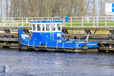
GRIENDUIL7
Cargo
Current Trip
ZWARTSLUIS
| Time Travelled | 9 days |
|---|---|
| Remaining Time | --- |
| Distance Travelled | 12.41 nm |
| Remaining Distance | --- |
| AVG Speed | 4.3 Knopen |
| MAX Speed | 6.8 Knopen |
| AVG Wind | 11.9 knots |
| MAX Wind | 16.9 knots |
| MIN Temp | -3.2°C / 26.24°F |
| MAX Temp | 4.8°C / 40.64°F |
| Diepgang | 0.2 M |
| Positie ontvangen | 16 h, 48 m geleden |
Current Position
| Lengtegraad | --- |
|---|---|
| Breedtegraat | --- |
| Status | Under way using engine |
| Snelheid | |
| Koers | --- |
| Gebied | North Sea |
| Station | T-AIS |
| Positie ontvangen | 16 h, 48 m geleden |
Info
Information
The current position of GRIENDUIL7 is in North Sea with coordinates 52.69733° / 6.02816° as reported on 2025-02-19 15:34 by AIS to our vessel tracker app. The vessel's current speed is 0 Knopen
The vessel GRIENDUIL7 (MMSI: 244780526) is a Cargo It's sailing under the flag of [NL] Netherlands.
In this page you can find informations about the vessels current position, last detected port calls, and current voyage information. If the vessels is not in coverage by AIS you will find the latest position.
The current position of GRIENDUIL7 is detected by our AIS receivers and we are not responsible for the reliability of the data. The last position was recorded while the vessel was in Coverage by the Ais receivers of our vessel tracking app.
The current draught of GRIENDUIL7 as reported by AIS is 0.2 meters
Weather
| Temperature | 3.9°C / 39.02°F |
|---|---|
| Wind Speed | 11 knots |
| Direction | 126° SE |
| Pressure | 1022.2 hPa |
| Humidity | 38.8 % |
| Cloud Coverage | 100 % |
Featured Company
Most Visited Ports (Last year)
| Port | Arrivals | |
|---|---|---|
| 4 | ||
| 2 | ||
| 1 | ||
| 1 | ||
| 1 | ||
| 1 |
Events
| Tijd | Evenement | Details | Positie / Bestemming | Info |
|---|---|---|---|---|
| 2025-02-19 15:34 | Buitenbereik |
52.69733 / 6.02816
North Sea
|
Snelheid: Koers: 0° |
|
| 2025-02-19 14:19 | Stop beweging | 1.63 nm, West of BLAUWE HAND |
52.69731 / 6.02822
ZWARTSLUIS
|
Snelheid: Koers: 511° |
| 2025-02-19 14:10 | Start beweging | 1.78 nm, North West of BELT SCHUTSLOOT |
52.69232 / 6.02269
ZWARTSLUIS
|
Snelheid: 3.4 kn Koers: 50.7° |
| 2025-02-19 13:09 | Stop beweging | 1.95 nm, North West of BELT SCHUTSLOOT |
52.69417 / 6.01905
ZWARTSLUIS
|
Snelheid: 0.3 kn Koers: 511° |
| 2025-02-19 12:58 | Start beweging | 1.67 nm, West of BLAUWE HAND |
52.69475 / 6.02679
ZWARTSLUIS
|
Snelheid: 5.3 kn Koers: 217° |
| 2025-02-19 09:52 | Stop beweging | 1.64 nm, West of BLAUWE HAND |
52.69694 / 6.02773
ZWARTSLUIS
|
Snelheid: Koers: 511° |
| 2025-02-19 09:42 | Start beweging | 1.78 nm, North West of BELT SCHUTSLOOT |
52.69217 / 6.02236
ZWARTSLUIS
|
Snelheid: 3.1 kn Koers: 124.3° |
| 2025-02-19 08:52 | Stop beweging | 1.95 nm, West of BLAUWE HAND |
52.69418 / 6.01907
ZWARTSLUIS
|
Snelheid: 0.1 kn Koers: 511° |
| 2025-02-19 08:44 | Start beweging | 1.7 nm, West of BLAUWE HAND |
52.69488 / 6.02590
ZWARTSLUIS
|
Snelheid: 5.2 kn Koers: 213.8° |
| 2025-02-19 08:21 | Binnenbereik |
52.69672 / 6.02752
North Sea
|
Snelheid: Koers: 57.6° |