
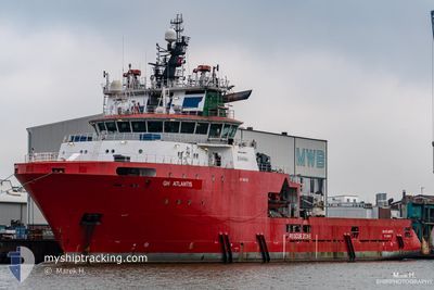
GH ATLANTIS
Anchor Handling Vessel
Current Trip
OFFSHORE BR
| Time Travelled | 39 days |
|---|---|
| Remaining Time | --- |
| Distance Travelled | 5332.01 nm |
| Remaining Distance | --- |
| AVG Speed | 6.6 Knopen |
| MAX Speed | 12.4 Knopen |
| AVG Wind | 12.8 knots |
| MAX Wind | 20 knots |
| MIN Temp | 20°C / 68°F |
| MAX Temp | 34°C / 93.2°F |
| Diepgang | 7.1 M |
| Positie ontvangen | 11 h, 4 m geleden |
Current Position
| Lengtegraad | -38.53549° |
|---|---|
| Breedtegraat | -12.93645° |
| Status | Restricted manoeuverability |
| Snelheid | |
| Koers | 90° |
| Gebied | South Atlantic Ocean |
| Station | T-AIS |
| Positie ontvangen | 11 h, 4 m geleden |
Info
Information
The current position of GH ATLANTIS is in South Atlantic Ocean with coordinates -12.93645° / -38.53549° as reported on 2024-06-07 13:19 by AIS to our vessel tracker app. The vessel's current speed is 0 Knopen
The vessel GH ATLANTIS (IMO: 9455117, MMSI: 304280000) is a Anchor Handling Vessel that was built in 2010 ( 14 Jaar oud ). It's sailing under the flag of [AG] Antigua Barbuda.
In this page you can find informations about the vessels current position, last detected port calls, and current voyage information. If the vessels is not in coverage by AIS you will find the latest position.
The current position of GH ATLANTIS is detected by our AIS receivers and we are not responsible for the reliability of the data. The last position was recorded while the vessel was in Coverage by the Ais receivers of our vessel tracking app.
The current draught of GH ATLANTIS as reported by AIS is 7.1 meters
Weather
| Temperature | 26.3°C / 79.34°F |
|---|---|
| Wind Speed | 12 knots |
| Direction | 121° ESE |
| Pressure | 1019.3 hPa |
| Humidity | 76.2 % |
| Cloud Coverage | 10 % |
Featured Company
Last Port Calls
| Port | Arrival | Departure | Time In Port |
|---|---|---|---|
| 2024-04-28 20:02 | 2024-04-29 08:26 | 12 h | |
| 2024-04-09 14:54 | 2024-04-09 16:08 | 1 h | |
| 2024-04-01 17:16 | 2024-04-01 20:03 | 2 h |
Most Visited Ports (Last year)
| Port | Arrivals | |
|---|---|---|
| 53 | ||
| 30 | ||
| 2 | ||
| 1 |
Events
| Tijd | Evenement | Details | Positie / Bestemming | Info |
|---|---|---|---|---|
| 2024-06-07 13:26 | Status Changed | Default Restricted manoeuverability |
-12.93628 / -38.53537
OFFSHORE BR
|
Snelheid: Koers: 90° |
| 2024-06-07 13:19 | Buitenbereik |
-12.93645 / -38.53549
South Atlantic Ocean
|
Snelheid: Koers: 25.4° |
|
| 2024-06-07 13:08 | Status Changed | Restricted manoeuverability Default |
-12.93674 / -38.53548
OFFSHORE BR
|
Snelheid: 0.1 kn Koers: 78° |
| 2024-06-07 12:58 | Binnenbereik |
-12.93674 / -38.53547
South Atlantic Ocean
|
Snelheid: 0.1 kn Koers: 351.3° |
|
| 2024-06-07 12:30 | Stop beweging | 2.2 nm, North West of SALVADOR |
-12.93708 / -38.53521
OFFSHORE BR
|
Snelheid: 0.1 kn Koers: 57° |
| 2024-06-07 11:58 | Start beweging | 2.65 nm, West of SALVADOR |
-12.97107 / -38.55938
OFFSHORE BR
|
Snelheid: 9.3 kn Koers: 44° |
| 2024-06-07 10:46 | Stop beweging | 3.26 nm, West of SALVADOR |
-12.97671 / -38.56908
OFFSHORE BR
|
Snelheid: 0.2 kn Koers: 38° |
| 2024-05-31 12:42 | Start beweging |
-7.37659 / -28.40379
OFFSHORE BR
|
Snelheid: 4.1 kn Koers: 173° |
|
| 2024-05-31 11:37 | Stop beweging |
-7.36167 / -28.38333
OFFSHORE BR
|
Snelheid: Koers: -1° |