
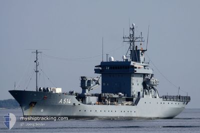
GERMAN WARSHIP A514
Military ops
Current Trip
Unknown
| Time Travelled | 3 days |
|---|---|
| Remaining Time | --- |
| Distance Travelled | 368.29 nm |
| Remaining Distance | --- |
| AVG Speed | 10.5 Knopen |
| MAX Speed | 16 Knopen |
| AVG Wind | 14.5 knots |
| MAX Wind | 21.3 knots |
| MIN Temp | 8.3°C / 46.94°F |
| MAX Temp | 20.4°C / 68.72°F |
| Diepgang | 0 M |
| Positie ontvangen | 2 h, 55 m geleden |
Current Position
| Lengtegraad | 9.86852° |
|---|---|
| Breedtegraat | 54.84055° |
| Status | Under way using engine |
| Snelheid | 15.6 Knopen |
| Koers | 258.4° |
| Gebied | Kattegat |
| Station | T-AIS |
| Positie ontvangen | 2 h, 55 m geleden |
Info
Information
The current position of GERMAN WARSHIP A514 is in Kattegat with coordinates 54.84055° / 9.86852° as reported on 2024-05-02 13:59 by AIS to our vessel tracker app. The vessel's current speed is 15.6 Knopen
The vessel GERMAN WARSHIP A514 (MMSI: 211210100) is a Military ops It's sailing under the flag of [DE] Germany.
In this page you can find informations about the vessels current position, last detected port calls, and current voyage information. If the vessels is not in coverage by AIS you will find the latest position.
The current position of GERMAN WARSHIP A514 is detected by our AIS receivers and we are not responsible for the reliability of the data. The last position was recorded while the vessel was in Coverage by the Ais receivers of our vessel tracking app.
Weather
| Temperature | 15°C / 59°F |
|---|---|
| Wind Speed | 16 knots |
| Direction | 85° E |
| Pressure | 1006.3 hPa |
| Humidity | 80 % |
| Cloud Coverage | --- |
Featured Company
Last Port Calls
| Port | Arrival | Departure | Time In Port |
|---|---|---|---|
| 2024-04-26 08:37 | 2024-04-29 07:40 | 2 d | |
| 2024-04-22 12:05 | 2024-04-22 13:02 | 57 m | |
| 2024-04-20 12:16 | 2024-04-21 10:45 | 22 h | |
| 2024-04-19 15:16 | 2024-04-20 09:33 | 18 h | |
| 2024-04-18 12:41 | 2024-04-18 14:23 | 1 h | |
| 2024-04-18 04:41 | 2024-04-18 08:18 | 3 h | |
| 2024-03-26 15:17 | 2024-04-15 08:17 | 19 d | |
| 2024-03-26 07:03 |
Most Visited Ports (Last year)
| Port | Arrivals | |
|---|---|---|
| 27 | ||
| 2 | ||
| 1 | ||
| 1 | ||
| 1 |
Last Trips
| Origin | Departure | Destination | Arrival | Distance | |
|---|---|---|---|---|---|
| 2024-04-22 15:02 | 2024-04-26 10:37 | 384.99 nm | |||
| 2024-04-21 12:45 | 2024-04-22 14:05 | 114.31 nm | |||
| 2024-04-20 11:33 | 2024-04-20 14:16 | 15.74 nm | |||
| 2024-04-18 16:23 | 2024-04-19 17:16 | 156.73 nm | |||
| 2024-04-18 10:18 | 2024-04-18 14:41 | 49.83 nm | |||
| 2024-04-15 10:17 | 2024-04-18 06:41 | 315.54 nm | |||
| 2024-03-26 08:03 | 2024-03-26 16:17 | 66.00 nm |
Events
| Tijd | Evenement | Details | Positie / Bestemming | Info |
|---|---|---|---|---|
| 2024-05-02 13:59 | Buitenbereik |
54.84055 / 9.86852
Kattegat
|
Snelheid: 15.6 kn Koers: 258.4° |
|
| 2024-05-02 13:50 | Wijzig zee gebeid | Danish part of the Kattegat German part of the Kattegat |
54.82903 / 9.92486
Kattegat
|
Snelheid: 15.3 kn Koers: 310.3° |
| 2024-05-02 13:37 | Wijzig zee gebeid | German part of the Kattegat German part of the Baltic Sea |
54.79057 / 9.99306
Kattegat
|
Snelheid: 15.1 kn Koers: 318.6° |
| 2024-05-02 11:32 | Wijzig zee gebeid | German part of the Baltic Sea Danish part of the Baltic Sea |
54.64830 / 10.31374
Baltic Sea
|
Snelheid: 14.8 kn Koers: 223.3° |
| 2024-05-02 11:02 | Wijzig zee gebeid | Danish part of the Baltic Sea German part of the Baltic Sea |
54.61205 / 10.40793
Baltic Sea
|
Snelheid: 14.1 kn Koers: 57.2° |
| 2024-05-02 10:42 | Status Changed | Under way using engine Not under command |
54.57735 / 10.30790
|
Snelheid: 8 kn Koers: 42° |
| 2024-05-02 10:40 | Status Changed | Not under command Under way using engine |
54.57407 / 10.30280
|
Snelheid: 9.4 kn Koers: 34.9° |
| 2024-05-02 07:44 | Wijzig zee gebeid | German part of the Baltic Sea Danish part of the Baltic Sea |
54.60464 / 10.41362
Baltic Sea
|
Snelheid: 15.3 kn Koers: 299.8° |
| 2024-05-02 07:05 | Wijzig zee gebeid | Danish part of the Baltic Sea German part of the Baltic Sea |
54.69497 / 10.29283
Baltic Sea
|
Snelheid: 14.8 kn Koers: 130° |
| 2024-05-02 04:03 | Start beweging | 0.44 nm, South West of MOELTENORT |
54.37082 / 10.18552
|
Snelheid: 3.5 kn Koers: 319° |