
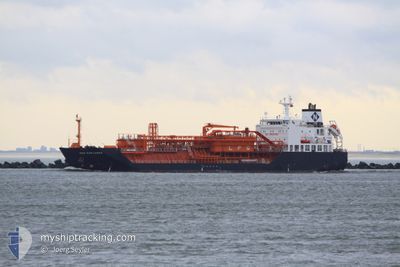
GAZ EXPLORER
Lpg Tanker
Current Trip
| Time Travelled | 38 days |
|---|---|
| Remaining Time | --- |
| Distance Travelled | 2121.76 nm |
| Remaining Distance | --- |
| AVG Speed | 7.3 Knopen |
| MAX Speed | 13.5 Knopen |
| AVG Wind | 12.4 knots |
| MAX Wind | 30 knots |
| MIN Temp | 14.1°C / 57.38°F |
| MAX Temp | 26.1°C / 78.98°F |
| Diepgang | 5.9 M |
| Positie ontvangen | 3 m geleden |
Current Position
| Lengtegraad | -6.85951° |
|---|---|
| Breedtegraat | 37.09210° |
| Status | At anchor |
| Snelheid | 0.1 Knopen |
| Koers | 255° |
| Gebied | North Atlantic Ocean |
| Station | T-AIS |
| Positie ontvangen | 3 m geleden |
Info
Information
The current position of GAZ EXPLORER is in North Atlantic Ocean with coordinates 37.09210° / -6.85951° as reported on 2024-05-27 14:31 by AIS to our vessel tracker app. The vessel's current speed is 0.1 Knopen
The vessel GAZ EXPLORER (IMO: 9506150, MMSI: 354588000) is a Lpg Tanker that was built in 2010 ( 14 Jaar oud ). It's sailing under the flag of [PA] Panama.
In this page you can find informations about the vessels current position, last detected port calls, and current voyage information. If the vessels is not in coverage by AIS you will find the latest position.
The current position of GAZ EXPLORER is detected by our AIS receivers and we are not responsible for the reliability of the data. The last position was recorded while the vessel was in Coverage by the Ais receivers of our vessel tracking app.
The current draught of GAZ EXPLORER as reported by AIS is 5.9 meters
Weather
| Temperature | 19.3°C / 66.74°F |
|---|---|
| Wind Speed | 12 knots |
| Direction | 234° SW |
| Pressure | 1015.6 hPa |
| Humidity | 70 % |
| Cloud Coverage | 31 % |
Featured Company
Events
| Tijd | Evenement | Details | Positie / Bestemming | Info |
|---|---|---|---|---|
| 2024-05-27 13:46 | Status Changed | At anchor Default |
37.09216 / -6.85951
ES HUV
|
Snelheid: Koers: 252° |
| 2024-05-27 13:37 | Status Changed | Default At anchor |
37.09208 / -6.85948
ES HUV
|
Snelheid: Koers: 250° |
| 2024-05-27 12:52 | Status Changed | At anchor Default |
37.09201 / -6.85955
ES HUV
|
Snelheid: Koers: 258° |
| 2024-05-27 12:40 | Status Changed | Default At anchor |
37.09192 / -6.85951
ES HUV
|
Snelheid: 0.1 kn Koers: 260° |
| 2024-05-27 12:22 | Status Changed | At anchor Default |
37.09187 / -6.85949
ES HUV
|
Snelheid: Koers: 264° |
| 2024-05-27 12:12 | Status Changed | Default At anchor |
37.09179 / -6.85947
ES HUV
|
Snelheid: 0.1 kn Koers: 261° |
| 2024-05-27 10:46 | Status Changed | At anchor Default |
37.09137 / -6.85949
ES HUV
|
Snelheid: Koers: 289° |
| 2024-05-27 10:43 | Status Changed | Default At anchor |
37.09133 / -6.85950
ES HUV
|
Snelheid: Koers: 287° |
| 2024-05-27 01:55 | Status Changed | At anchor Default |
37.09084 / -6.85988
ES HUV
|
Snelheid: Koers: 322° |
| 2024-05-27 01:46 | Status Changed | Default At anchor |
37.09085 / -6.85992
ES HUV
|
Snelheid: 0.1 kn Koers: 316° |