
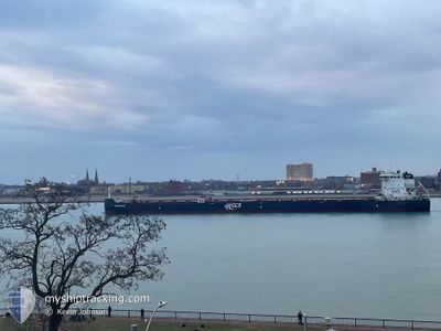
G3 MARQUIS
Cargo
Current Trip
| Time Travelled | 20 h, 5 mins |
|---|---|
| Remaining Time | --- |
| Distance Travelled | 138.85 nm |
| Remaining Distance | --- |
| AVG Speed | 12.3 Knopen |
| MAX Speed | 14.1 Knopen |
| AVG Wind | 16 knots |
| MAX Wind | 20.8 knots |
| MIN Temp | -6.9°C / 19.58°F |
| MAX Temp | -1.8°C / 28.76°F |
| Diepgang | 7.9 M |
| Positie ontvangen | 18 h, 39 m geleden |
Current Position
| Lengtegraad | --- |
|---|---|
| Breedtegraat | --- |
| Status | Under way using engine |
| Snelheid | 13.7 Knopen |
| Koers | 74.4° |
| Gebied | Gulf of St-Lawrence |
| Station | T-AIS |
| Positie ontvangen | 18 h, 39 m geleden |
Info
Information
The current position of G3 MARQUIS is in Gulf of St-Lawrence with coordinates 43.37683° / -78.88503° as reported on 2026-01-03 14:36 by AIS to our vessel tracker app. The vessel's current speed is 13.7 Knopen and is heading at the port of BAIE COMEAU. The estimated time of arrival as calculated by MyShipTracking vessel tracking app is 2026-01-05 12:00 LT
The vessel G3 MARQUIS (IMO: 9613941, MMSI: 316004370) is a Cargo It's sailing under the flag of [CA] Canada.
In this page you can find informations about the vessels current position, last detected port calls, and current voyage information. If the vessels is not in coverage by AIS you will find the latest position.
The current position of G3 MARQUIS is detected by our AIS receivers and we are not responsible for the reliability of the data. The last position was recorded while the vessel was in Coverage by the Ais receivers of our vessel tracking app.
The current draught of G3 MARQUIS as reported by AIS is 7.9 meters
Weather
| Temperature | -7.5°C / 18.5°F |
|---|---|
| Wind Speed | 6 knots |
| Direction | 59° ENE |
| Pressure | 1016.9 hPa |
| Humidity | 92 % |
| Cloud Coverage | 100 % |
Featured Company
Last Port Calls
| Port | Arrival | Departure | Time In Port |
|---|---|---|---|
| 2026-01-03 06:38 | 2026-01-03 08:10 | 1 h | |
| 2025-12-31 21:19 | 2025-12-31 23:22 | 2 h | |
| 2025-12-28 15:50 | 2025-12-30 15:26 | 1 d | |
| 2025-12-27 18:45 | 2025-12-27 19:32 | 46 m | |
| 2025-12-25 10:27 | 2025-12-25 11:54 | 1 h | |
| 2025-12-23 12:21 | 2025-12-23 17:08 | 4 h | |
| 2025-12-16 23:14 | 2025-12-19 02:12 | 2 d | |
| 2025-12-16 10:29 | 2025-12-16 12:01 | 1 h | |
| 2025-12-16 04:23 | 2025-12-16 04:58 | 34 m | |
| 2025-12-13 19:33 | 2025-12-13 21:30 | 1 h |
Most Visited Ports (Last year)
| Port | Arrivals | |
|---|---|---|
| 32 | ||
| 30 | ||
| 25 | ||
| 14 | ||
| 14 | ||
| 13 |
Last Trips
| Origin | Departure | Destination | Arrival | Distance | |
|---|---|---|---|---|---|
| 2025-12-31 23:22 | 2026-01-03 06:38 | 526.34 nm | |||
| 2025-12-30 15:26 | 2025-12-31 21:19 | 238.88 nm | |||
| 2025-12-27 19:32 | 2025-12-28 15:50 | 236.63 nm | |||
| 2025-12-25 11:54 | 2025-12-27 18:45 | 523.27 nm | |||
| 2025-12-23 17:08 | 2025-12-25 10:27 | 298.80 nm | |||
| 2025-12-19 02:12 | 2025-12-23 12:21 | 140.31 nm | |||
| 2025-12-16 12:01 | 2025-12-16 23:14 | 130.35 nm | |||
| 2025-12-16 04:58 | 2025-12-16 10:29 | 5.57 nm | |||
| 2025-12-13 21:30 | 2025-12-16 04:23 | 293.55 nm | |||
| 2025-12-11 11:54 | 2025-12-13 19:33 | 524.28 nm |
Events
| Tijd | Evenement | Details | Positie / Bestemming | Info |
|---|---|---|---|---|
| 2026-01-03 23:57 | Stop beweging | 7.23 nm, South of MARYSVILLE |
44.08167 / -76.38666
BAIE COMEAU
|
Snelheid: Koers: -1° |
| 2026-01-03 14:38 | Status Changed | Default Under way using engine |
43.37833 / -78.87500
BAIE COMEAU
|
Snelheid: 13.7 kn Koers: 74.4° |
| 2026-01-03 14:36 | Buitenbereik |
43.37683 / -78.88503
Gulf of St-Lawrence
BAIE COMEAU
|
Snelheid: 13.7 kn Koers: 74.4° |
|
| 2026-01-03 13:10 | Vertrekhaven |
|
43.23090 / -79.21676
BAIE COMEAU
|
Snelheid: 5.7 kn Koers: 0° |
| 2026-01-03 13:00 | Start beweging |
43.22049 / -79.21447
[CA] PORT WELLER
|
Snelheid: 3.4 kn Koers: 346° |
|
| 2026-01-03 11:39 | Stop beweging |
43.20990 / -79.21073
[CA] PORT WELLER
|
Snelheid: 0.3 kn Koers: 344° |
|
| 2026-01-03 11:38 | Aankomsthaven |
|
43.20984 / -79.21072
[CA] PORT WELLER
|
Snelheid: 0.6 kn Koers: 345° |
| 2026-01-03 11:15 | Start beweging | 1.54 nm, South of PORT WELLER |
43.19570 / -79.20386
BAIE COMEAU
|
Snelheid: 3.1 kn Koers: 336° |
| 2026-01-03 10:28 | Stop beweging | 1.77 nm, South of PORT WELLER |
43.19214 / -79.20178
BAIE COMEAU
|
Snelheid: 0.3 kn Koers: 338° |
| 2026-01-03 09:31 | Start beweging | 3.58 nm, South of PORT WELLER |
43.16251 / -79.19420
BAIE COMEAU
|
Snelheid: 3.1 kn Koers: 351° |