
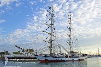
FRYDERYK CHOPIN
Sailing Vessel
Current Trip
CABO VERDE
| Time Travelled | 4 days |
|---|---|
| Remaining Time | --- |
| Distance Travelled | 591.79 nm |
| Remaining Distance | --- |
| AVG Speed | 5.9 Knopen |
| MAX Speed | 12.1 Knopen |
| AVG Wind | 14.9 knots |
| MAX Wind | 28 knots |
| MIN Temp | 21.4°C / 70.52°F |
| MAX Temp | 25°C / 77°F |
| Diepgang | 4.1 M |
| Positie ontvangen | 1 d geleden |
Current Position
| Lengtegraad | --- |
|---|---|
| Breedtegraat | --- |
| Status | Under way sailing |
| Snelheid | 5.2 Knopen |
| Koers | 230.5° |
| Gebied | North Atlantic Ocean |
| Station | T-AIS |
| Positie ontvangen | 1 d geleden |
Info
Information
The current position of FRYDERYK CHOPIN is in North Atlantic Ocean with coordinates 19.51042° / -19.84950° as reported on 2024-10-20 04:27 by AIS to our vessel tracker app. The vessel's current speed is 5.2 Knopen
The vessel FRYDERYK CHOPIN (IMO: 9030747, MMSI: 261000290) is a Sailing Vessel that was built in 1992 ( 32 Jaar oud ). It's sailing under the flag of [PL] Poland.
In this page you can find informations about the vessels current position, last detected port calls, and current voyage information. If the vessels is not in coverage by AIS you will find the latest position.
The current position of FRYDERYK CHOPIN is detected by our AIS receivers and we are not responsible for the reliability of the data. The last position was recorded while the vessel was in Coverage by the Ais receivers of our vessel tracking app.
The current draught of FRYDERYK CHOPIN as reported by AIS is 4.1 meters
Weather
| Temperature | 25°C / 77°F |
|---|---|
| Wind Speed | 16 knots |
| Direction | 29° NNE |
| Pressure | 1012.9 hPa |
| Humidity | 75.2 % |
| Cloud Coverage | 99 % |
Featured Company
Last Port Calls
| Port | Arrival | Departure | Time In Port |
|---|---|---|---|
| 2024-10-13 14:10 | 2024-10-16 13:07 | 2 d | |
| 2024-09-29 03:27 | 2024-10-02 14:26 | 3 d | |
| 2024-09-21 14:20 | 2024-09-23 13:21 | 1 d | |
| 2024-09-19 07:54 | 2024-09-21 06:59 | 1 d | |
| 2024-09-14 15:27 | 2024-09-16 14:28 | 1 d | |
| 2024-09-07 14:07 | 2024-09-09 18:18 | 2 d | |
| 2024-08-30 16:31 | 2024-09-02 08:55 | 2 d | |
| 2024-08-24 05:26 | 2024-08-27 08:55 | 3 d | |
| 2024-08-21 14:45 | 2024-08-23 19:29 | 2 d | |
| 2024-08-17 15:41 | 2024-08-18 17:38 | 1 d |
Most Visited Ports (Last year)
| Port | Arrivals | |
|---|---|---|
| 3 | ||
| 3 | ||
| 2 | ||
| 2 | ||
| 2 | ||
| 1 |
Last Trips
| Origin | Departure | Destination | Arrival | Distance | |
|---|---|---|---|---|---|
| 2024-10-02 16:26 | 2024-10-13 15:10 | 828.58 nm | |||
| 2024-09-23 15:21 | 2024-09-29 05:27 | 304.71 nm | |||
| 2024-09-21 08:59 | 2024-09-21 16:20 | 63.40 nm | |||
| 2024-09-16 15:28 | 2024-09-19 09:54 | 249.97 nm | |||
| 2024-09-09 20:18 | 2024-09-14 16:27 | 486.35 nm | |||
| 2024-09-02 10:55 | 2024-09-07 16:07 | 548.99 nm | |||
| 2024-08-27 10:55 | 2024-08-30 18:31 | 369.60 nm | |||
| 2024-08-23 21:29 | 2024-08-24 07:26 | 59.47 nm | |||
| 2024-08-18 19:38 | 2024-08-21 16:45 | 470.78 nm | |||
| 2024-08-17 13:57 | 2024-08-17 17:41 | 30.45 nm |
Events
| Tijd | Evenement | Details | Positie / Bestemming | Info |
|---|---|---|---|---|
| 2024-10-20 04:27 | Buitenbereik |
19.51042 / -19.84950
North Atlantic Ocean
CABO VERDE
|
Snelheid: 5.2 kn Koers: 230.5° |
|
| 2024-10-20 04:14 | Binnenbereik |
19.52253 / -19.83525
North Atlantic Ocean
CABO VERDE
|
Snelheid: 5.2 kn Koers: 232.8° |
|
| 2024-10-20 03:14 | Buitenbereik |
19.57477 / -19.77789
North Atlantic Ocean
CABO VERDE
|
Snelheid: 4.9 kn Koers: 216.4° |
|
| 2024-10-20 00:47 | Binnenbereik |
19.73959 / -19.59483
North Atlantic Ocean
CABO VERDE
|
Snelheid: 5.9 kn Koers: 210.4° |
|
| 2024-10-19 12:23 | Buitenbereik |
20.68124 / -18.47921
North Atlantic Ocean
CABO VERDE
|
Snelheid: 6.2 kn Koers: 228.7° |
|
| 2024-10-19 11:50 | Binnenbereik |
20.71716 / -18.43717
North Atlantic Ocean
CABO VERDE
|
Snelheid: 5.5 kn Koers: 226.1° |
|
| 2024-10-19 09:33 | Buitenbereik |
20.85401 / -18.24615
North Atlantic Ocean
CABO VERDE
|
Snelheid: 6.6 kn Koers: 196.1° |
|
| 2024-10-19 08:16 | Binnenbereik |
20.99989 / -18.23079
North Atlantic Ocean
CABO VERDE
|
Snelheid: 6.2 kn Koers: 179.5° |
|
| 2024-10-19 07:12 | Buitenbereik |
21.11083 / -18.22457
North Atlantic Ocean
CABO VERDE
|
Snelheid: 5.3 kn Koers: 189.5° |
|
| 2024-10-19 05:23 | Draught Changed | 4.1 4 |
21.28190 / -18.22070
CABO VERDE
|
Snelheid: 5.5 kn Koers: 185.7° |