
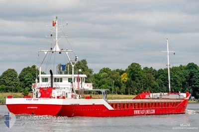
FLYING SPUR
General Cargo
Current Trip
| Time Travelled | 4 days |
|---|---|
| Remaining Time | --- |
| Distance Travelled | 385.96 nm |
| Remaining Distance | --- |
| AVG Speed | 9.3 Knopen |
| MAX Speed | 10.5 Knopen |
| AVG Wind | 10.8 knots |
| MAX Wind | 20 knots |
| MIN Temp | 16.6°C / 61.88°F |
| MAX Temp | 17.9°C / 64.22°F |
| Diepgang | 3.8 M |
| Positie ontvangen | 5 m geleden |
Current Position
| Lengtegraad | --- |
|---|---|
| Breedtegraat | --- |
| Status | At anchor |
| Snelheid | 0.1 Knopen |
| Koers | --- |
| Gebied | Aegean Sea |
| Station | T-AIS |
| Positie ontvangen | 5 m geleden |
Info
Information
The current position of FLYING SPUR is in Aegean Sea with coordinates 36.92970° / 26.99596° as reported on 2025-01-14 20:09 by AIS to our vessel tracker app. The vessel's current speed is 0.1 Knopen
The vessel FLYING SPUR (IMO: 9085455, MMSI: 341250001) is a General Cargo that was built in 1994 ( 31 Jaar oud ). It's sailing under the flag of [KN] St Kitts Nevis.
In this page you can find informations about the vessels current position, last detected port calls, and current voyage information. If the vessels is not in coverage by AIS you will find the latest position.
The current position of FLYING SPUR is detected by our AIS receivers and we are not responsible for the reliability of the data. The last position was recorded while the vessel was in Coverage by the Ais receivers of our vessel tracking app.
The current draught of FLYING SPUR as reported by AIS is 3.8 meters
Weather
| Temperature | 16.8°C / 62.24°F |
|---|---|
| Wind Speed | 15 knots |
| Direction | 172° S |
| Pressure | 1019.4 hPa |
| Humidity | 70.5 % |
| Cloud Coverage | 85 % |
Featured Company
Last Port Calls
| Port | Arrival | Departure | Time In Port |
|---|---|---|---|
| 2025-01-07 11:37 | 2025-01-10 21:58 | 3 d | |
| 2025-01-02 11:30 | 2025-01-04 13:32 | 2 d | |
| 2024-12-25 21:40 | 2024-12-28 13:08 | 2 d | |
| 2024-12-23 18:31 | 2024-12-25 15:25 | 1 d | |
| 2024-12-18 18:28 | 2024-12-20 14:40 | 1 d | |
| 2024-12-06 16:56 | 2024-12-08 01:56 | 1 d | |
| 2024-11-27 19:24 | 2024-11-30 11:52 | 2 d | |
| 2024-11-21 20:41 | |||
| 2024-11-09 18:48 | |||
| 2024-11-03 01:28 |
Most Visited Ports (Last year)
| Port | Arrivals | |
|---|---|---|
| 9 | ||
| 3 | ||
| 3 | ||
| 3 | ||
| 2 | ||
| 1 |
Last Trips
| Origin | Departure | Destination | Arrival | Distance | |
|---|---|---|---|---|---|
| 2025-01-04 13:32 | 2025-01-07 11:37 | 134.19 nm | |||
| 2024-12-28 13:08 | 2025-01-02 11:30 | 868.08 nm | |||
| 2024-12-25 15:25 | 2024-12-25 21:40 | 61.66 nm | |||
| 2024-12-20 14:40 | 2024-12-23 18:31 | 561.45 nm | |||
| 2024-12-08 01:56 | 2024-12-18 18:28 | 8059.01 nm | |||
| 2024-11-30 11:52 | 2024-12-06 16:56 | 458.20 nm | |||
| 2024-11-21 20:41 | 2024-11-27 19:24 | 250.33 nm | |||
| 2024-11-03 01:28 | 2024-11-09 18:48 | 616.77 nm |
Events
| Tijd | Evenement | Details | Positie / Bestemming | Info |
|---|---|---|---|---|
| 2025-01-14 19:56 | Binnenbereik |
36.92964 / 26.99593
Aegean Sea
|
Snelheid: Koers: 122.7° |
|
| 2025-01-12 15:27 | Stop beweging | 1.26 nm, South of KALYMNOS |
36.92864 / 26.99537
KALYMNOS
|
Snelheid: 0.2 kn Koers: 211° |
| 2025-01-12 14:40 | Status Changed | Default Under way using engine |
36.86310 / 26.96620
KALYMNOS
|
Snelheid: 9.1 kn Koers: 39.9° |
| 2025-01-12 14:32 | Buitenbereik |
36.84558 / 26.94872
Aegean Sea
KALYMNOS
|
Snelheid: 9.1 kn Koers: 39.9° |
|
| 2025-01-12 11:45 | Draught Changed | 3.8 3.6 |
36.43300 / 26.87108
KALYMNOS
|
Snelheid: 9.8 kn Koers: 338.2° |
| 2025-01-12 11:45 | Destination Changed | KALYMNOS EGDAM |
36.43300 / 26.87108
KALYMNOS
|
Snelheid: 9.8 kn Koers: 338.2° |
| 2025-01-12 11:45 | ETA Changed | 2025/01/12 18:00 2025/01/03 10:00 |
36.43300 / 26.87108
KALYMNOS
|
Snelheid: 9.8 kn Koers: 338.2° |
| 2025-01-12 10:46 | Binnenbereik |
36.28123 / 26.95312
Aegean Sea
|
Snelheid: 10.3 kn Koers: 314.9° |
|
| 2025-01-12 08:12 | Status Changed | Default Under way using engine |
35.96195 / 27.30647
EGDAM
|
Snelheid: 9.7 kn Koers: 321.1° |
| 2025-01-12 07:54 | Buitenbereik |
35.92582 / 27.34812
Aegean Sea
|
Snelheid: 9.7 kn Koers: 321.1° |