
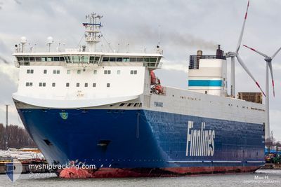
FINNWAVE
Ro-Ro Cargo
Current Trip
| Time Travelled | 9 h, 59 mins |
|---|---|
| Remaining Time | 17 h, 24 mins |
| Distance Travelled | 190.41 nm |
| Remaining Distance | 331.47 nm |
| AVG Speed | 19.3 Knopen |
| MAX Speed | 21.6 Knopen |
| AVG Wind | 4.5 knots |
| MAX Wind | 10 knots |
| MIN Temp | 12°C / 53.6°F |
| MAX Temp | 13.7°C / 56.66°F |
| Diepgang | 6.4 M |
| Positie ontvangen | Nu |
Current Position
| Lengtegraad | -4.70467° |
|---|---|
| Breedtegraat | 49.94069° |
| Status | Under way using engine |
| Snelheid | 19.5 Knopen |
| Koers | 79.1° |
| Gebied | English Channel |
| Station | T-AIS |
| Positie ontvangen | Nu |
Info
Information
The current position of FINNWAVE is in English Channel with coordinates 49.94069° / -4.70467° as reported on 2024-05-17 06:53 by AIS to our vessel tracker app. The vessel's current speed is 19.5 Knopen and is heading at the port of ZEEBRUGGE. The estimated time of arrival as calculated by MyShipTracking vessel tracking app is 2024-05-18 02:18 LT
The vessel FINNWAVE (IMO: 9468932, MMSI: 230632000) is a Ro-Ro Cargo that was built in 2012 ( 12 Jaar oud ). It's sailing under the flag of [FI] Finland.
In this page you can find informations about the vessels current position, last detected port calls, and current voyage information. If the vessels is not in coverage by AIS you will find the latest position.
The current position of FINNWAVE is detected by our AIS receivers and we are not responsible for the reliability of the data. The last position was recorded while the vessel was in Coverage by the Ais receivers of our vessel tracking app.
The current draught of FINNWAVE as reported by AIS is 6.4 meters
Weather
| Temperature | 13.3°C / 55.94°F |
|---|---|
| Wind Speed | 4 knots |
| Direction | 66° ENE |
| Pressure | 1007 hPa |
| Humidity | 79 % |
| Cloud Coverage | 46 % |
Featured Company
Last Port Calls
| Port | Arrival | Departure | Time In Port |
|---|---|---|---|
| 2024-05-16 04:01 | 2024-05-16 21:55 | 17 h | |
| 2024-05-14 10:57 | 2024-05-15 01:20 | 14 h | |
| 2024-05-12 19:42 | 2024-05-13 03:12 | 7 h | |
| 2024-05-11 04:59 | 2024-05-11 15:15 | 10 h | |
| 2024-05-09 04:02 | 2024-05-09 21:56 | 17 h | |
| 2024-05-07 11:43 | 2024-05-07 21:21 | 9 h | |
| 2024-05-05 19:17 | 2024-05-06 03:10 | 7 h | |
| 2024-05-04 05:00 | 2024-05-04 15:25 | 10 h | |
| 2024-05-02 03:32 | 2024-05-02 21:53 | 18 h | |
| 2024-04-30 11:58 | 2024-04-30 19:14 | 7 h |
Last Trips
| Origin | Departure | Destination | Arrival | Distance | |
|---|---|---|---|---|---|
| 2024-05-15 01:20 | 2024-05-16 04:01 | 512.69 nm | |||
| 2024-05-13 03:12 | 2024-05-14 10:57 | 522.50 nm | |||
| 2024-05-11 15:15 | 2024-05-12 19:42 | 511.70 nm | |||
| 2024-05-09 21:56 | 2024-05-11 04:59 | 522.02 nm | |||
| 2024-05-07 21:21 | 2024-05-09 04:02 | 511.56 nm | |||
| 2024-05-06 03:10 | 2024-05-07 11:43 | 523.64 nm | |||
| 2024-05-04 15:25 | 2024-05-05 19:17 | 510.09 nm | |||
| 2024-05-02 21:53 | 2024-05-04 05:00 | 520.75 nm | |||
| 2024-04-30 19:14 | 2024-05-02 03:32 | 514.60 nm | |||
| 2024-04-29 03:11 | 2024-04-30 11:58 | 521.69 nm |
Events
| Tijd | Evenement | Details | Positie / Bestemming | Info |
|---|---|---|---|---|
| 2024-05-17 05:08 | Wijzig zee gebeid | United Kingdom part of the English Channel United Kingdom part of the Celtic Sea |
49.88741 / -5.55546
English Channel
ZEEBRUGGE
|
Snelheid: 19 kn Koers: 91.5° |
| 2024-05-17 02:57 | Status Changed | Under way using engine Default |
50.34787 / -6.00161
ZEEBRUGGE
|
Snelheid: 19.7 kn Koers: 167° |
| 2024-05-17 02:27 | Status Changed | Default Under way using engine |
50.51180 / -6.04806
ZEEBRUGGE
|
Snelheid: 19.6 kn Koers: 172.8° |
| 2024-05-17 01:04 | Status Changed | Under way using engine Default |
50.95794 / -6.11353
ZEEBRUGGE
|
Snelheid: 19.3 kn Koers: 173° |
| 2024-05-17 01:03 | Status Changed | Default Under way using engine |
50.96488 / -6.11446
ZEEBRUGGE
|
Snelheid: 19.3 kn Koers: 173° |
| 2024-05-17 01:02 | Status Changed | Under way using engine Default |
50.96862 / -6.11497
ZEEBRUGGE
|
Snelheid: 19.3 kn Koers: 173° |
| 2024-05-17 00:43 | Status Changed | Default Under way using engine |
51.07145 / -6.12953
ZEEBRUGGE
|
Snelheid: 19.3 kn Koers: 172.3° |
| 2024-05-17 00:37 | Status Changed | Under way using engine Default |
51.10085 / -6.13404
ZEEBRUGGE
|
Snelheid: 19.1 kn Koers: 172° |
| 2024-05-17 00:31 | Status Changed | Default Under way using engine |
51.13541 / -6.13951
ZEEBRUGGE
|
Snelheid: 19.2 kn Koers: 172.4° |
| 2024-05-17 00:24 | Status Changed | Under way using engine Default |
51.16793 / -6.14448
ZEEBRUGGE
|
Snelheid: 19.2 kn Koers: 173° |