

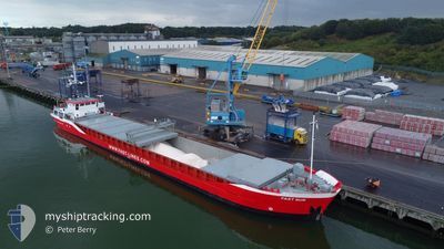
FAST SUS
General Cargo

Current Trip
| Time Travelled | 1 day |
|---|---|
| Remaining Time | 1 day |
| Distance Travelled | 408.58 nm |
| Remaining Distance | 286.06 nm |
| AVG Speed | 8 Knopen |
| MAX Speed | 13.8 Knopen |
| AVG Wind | 6.7 knots |
| MAX Wind | 21 knots |
| MIN Temp | -4.8°C / 23.36°F |
| MAX Temp | 1°C / 33.8°F |
| Diepgang | 3.8 M |
| Positie ontvangen | 1 m geleden |
Current Position
| Lengtegraad | --- |
|---|---|
| Breedtegraat | --- |
| Status | Under way using engine |
| Snelheid | 11.2 Knopen |
| Koers | 251.1° |
| Gebied | North Sea |
| Station | T-AIS |
| Positie ontvangen | 1 m geleden |
Information
The current position of FAST SUS is in North Sea with coordinates 53.62120° / 5.30617° as reported on 2025-02-17 17:52 by AIS to our vessel tracker app. The vessel's current speed is 11.2 Knopen and is heading at the port of SHOREHAM. The estimated time of arrival as calculated by MyShipTracking vessel tracking app is 2025-02-18 19:10 LT
The vessel FAST SUS (IMO: 9136096, MMSI: 205482000) is a General Cargo that was built in 1996 ( 29 Jaar oud ). It's sailing under the flag of [BE] Belgium.
In this page you can find informations about the vessels current position, last detected port calls, and current voyage information. If the vessels is not in coverage by AIS you will find the latest position.
The current position of FAST SUS is detected by our AIS receivers and we are not responsible for the reliability of the data. The last position was recorded while the vessel was in Coverage by the Ais receivers of our vessel tracking app.
The current draught of FAST SUS as reported by AIS is 3.8 meters
Weather
| Temperature | 1°C / 33.8°F |
|---|---|
| Wind Speed | 13 knots |
| Direction | 85° E |
| Pressure | 1025.8 hPa |
| Humidity | 65.2 % |
| Cloud Coverage | 34 % |


Featured Company
Last Port Calls
| Port | Arrival | Departure | Time In Port |
|---|---|---|---|
| 2025-02-14 19:21 | 2025-02-15 18:36 | 23 h | |
| 2025-02-13 10:18 | 2025-02-13 18:08 | 7 h | |
| 2025-02-08 09:08 | 2025-02-10 17:30 | 2 d | |
| 2025-02-04 11:25 | 2025-02-06 23:06 | 2 d | |
| 2025-02-02 04:39 | 2025-02-02 06:13 | 1 h | |
| 2025-01-30 09:17 | 2025-01-31 17:56 | 1 d | |
| 2025-01-28 05:37 | 2025-01-28 17:20 | 11 h | |
| 2025-01-25 10:55 | 2025-01-26 11:42 | 1 d | |
| 2025-01-21 18:26 | 2025-01-23 17:16 | 1 d | |
| 2025-01-19 13:41 | 2025-01-19 15:16 | 1 h |
Last Trips
| Origin | Departure | Destination | Arrival | Distance | |
|---|---|---|---|---|---|
| 2025-02-13 19:08 | 2025-02-14 20:21 | 234.10 nm | |||
| 2025-02-10 18:30 | 2025-02-13 11:18 | 474.86 nm | |||
| 2025-02-06 23:06 | 2025-02-08 10:08 | 259.94 nm | |||
| 2025-02-02 07:13 | 2025-02-04 11:25 | 379.46 nm | |||
| 2025-01-31 18:56 | 2025-02-02 05:39 | 267.49 nm | |||
| 2025-01-28 18:20 | 2025-01-30 10:17 | 388.93 nm | |||
| 2025-01-26 11:42 | 2025-01-28 06:37 | 368.55 nm | |||
| 2025-01-23 17:16 | 2025-01-25 10:55 | 300.90 nm | |||
| 2025-01-19 16:16 | 2025-01-21 18:26 | 185.60 nm | |||
| 2025-01-18 08:06 | 2025-01-19 14:41 | 259.71 nm |
Events
| Tijd | Evenement | Details | Positie / Bestemming | Info |
|---|---|---|---|---|
| 2025-02-17 16:00 | Wijzig zee gebeid | Dutch part of the North Sea German part of the North Sea |
53.74499 / 5.86604
North Sea
GBSHO
|
Snelheid: 11.2 kn Koers: 247.9° |
| 2025-02-17 16:00 | Status Changed | Under way using engine Default |
53.74499 / 5.86604
GBSHO
|
Snelheid: 11.1 kn Koers: 247° |
| 2025-02-17 15:48 | Binnenbereik |
53.74499 / 5.86604
North Sea
GBSHO
|
Snelheid: 11.2 kn Koers: 247.9° |
|
| 2025-02-17 06:37 | Status Changed | Default Under way using engine |
53.97990 / 8.49092
GBSHO
|
Snelheid: 13.4 kn Koers: 281.3° |
| 2025-02-17 06:32 | Buitenbereik |
53.97416 / 8.52261
North Sea
GBSHO
|
Snelheid: 13.4 kn Koers: 281.3° |
|
| 2025-02-17 04:11 | Start beweging | 0.9 nm, South West of BRUNSBUETTEL |
53.89210 / 9.14246
GBSHO
|
Snelheid: 4.4 kn Koers: 229° |
| 2025-02-17 03:09 | Stop beweging | 0.79 nm, South West of BRUNSBUETTEL |
53.89328 / 9.14480
GBSHO
|
Snelheid: 0.3 kn Koers: 226° |
| 2025-02-17 03:08 | Gevonden in zee | German part of the North Sea |
53.89341 / 9.14515
North Sea
GBSHO
|
Snelheid: 0.9 kn Koers: 228.5° |
| 2025-02-17 00:55 | Status Changed | Under way using engine Default |
54.09687 / 9.32800
GBSHO
|
Snelheid: 7.1 kn Koers: 189° |
| 2025-02-17 00:49 | Status Changed | Default Under way using engine |
54.10757 / 9.32927
GBSHO
|
Snelheid: 7.2 kn Koers: 185.1° |