
ELEONORA
General Cargo
Current Trip
| Time Travelled | 2 days |
|---|---|
| Remaining Time | 1 day |
| Distance Travelled | 397.06 nm |
| Remaining Distance | 245.02 nm |
| AVG Speed | 7.9 Knopen |
| MAX Speed | 11.1 Knopen |
| AVG Wind | 8.5 knots |
| MAX Wind | 16.5 knots |
| MIN Temp | 5.4°C / 41.72°F |
| MAX Temp | 12.6°C / 54.68°F |
| Diepgang | 4.5 M |
| Positie ontvangen | Nu |
Current Position
| Lengtegraad | --- |
|---|---|
| Breedtegraat | --- |
| Status | Under way using engine |
| Snelheid | 6.2 Knopen |
| Koers | 18.1° |
| Gebied | North Sea |
| Station | T-AIS |
| Positie ontvangen | Nu |
Information
The current position of ELEONORA is in North Sea with coordinates 54.23792° / 9.60942° as reported on 2025-03-27 20:37 by AIS to our vessel tracker app. The vessel's current speed is 6.2 Knopen and is heading at the port of KARLSHAMN. The estimated time of arrival as calculated by MyShipTracking vessel tracking app is 2025-03-29 07:48 LT
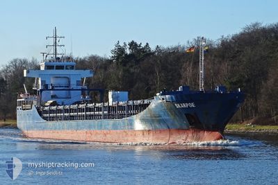
The vessel ELEONORA (IMO: 9393785, MMSI: 209956000) is a General Cargo that was built in 2011 ( 14 Jaar oud ). It's sailing under the flag of [CY] Cyprus.
In this page you can find informations about the vessels current position, last detected port calls, and current voyage information. If the vessels is not in coverage by AIS you will find the latest position.
The current position of ELEONORA is detected by our AIS receivers and we are not responsible for the reliability of the data. The last position was recorded while the vessel was in Coverage by the Ais receivers of our vessel tracking app.
The current draught of ELEONORA as reported by AIS is 4.5 meters
Weather
| Temperature | 6.1°C / 42.98°F |
|---|---|
| Wind Speed | 5 knots |
| Direction | 226° SW |
| Pressure | 1017 hPa |
| Humidity | 87.2 % |
| Cloud Coverage | 20 % |
Featured Company
Last Port Calls
| Port | Arrival | Departure | Time In Port |
|---|---|---|---|
| 2025-03-23 05:02 | 2025-03-25 19:12 | 2 d | |
| 2025-03-13 13:50 | 2025-03-17 23:19 | 4 d | |
| 2025-03-09 10:54 | 2025-03-12 13:03 | 3 d | |
| 2025-03-04 13:51 | 2025-03-06 13:43 | 1 d | |
| 2025-02-23 18:15 | 2025-02-26 20:28 | 3 d | |
| 2025-02-13 07:09 | 2025-02-18 15:59 | 5 d | |
| 2025-02-05 01:18 | 2025-02-06 22:29 | 1 d | |
| 2025-01-29 00:52 | 2025-01-30 20:15 | 1 d | |
| 2025-01-24 18:20 | 2025-01-27 15:50 | 2 d | |
| 2025-01-21 08:37 | 2025-01-23 11:15 | 2 d |
Last Trips
| Origin | Departure | Destination | Arrival | Distance | |
|---|---|---|---|---|---|
| 2025-03-18 00:19 | 2025-03-23 05:02 | 658.37 nm | |||
| 2025-03-12 14:03 | 2025-03-13 14:50 | 172.59 nm | |||
| 2025-03-06 14:43 | 2025-03-09 11:54 | 587.84 nm | |||
| 2025-02-26 20:28 | 2025-03-04 14:51 | 152.74 nm | |||
| 2025-02-18 16:59 | 2025-02-23 18:15 | 660.89 nm | |||
| 2025-02-06 23:29 | 2025-02-13 08:09 | 288.38 nm | |||
| 2025-01-30 21:15 | 2025-02-05 02:18 | 679.61 nm | |||
| 2025-01-27 17:50 | 2025-01-29 01:52 | 317.82 nm | |||
| 2025-01-23 12:15 | 2025-01-24 20:20 | 325.93 nm | |||
| 2025-01-16 20:50 | 2025-01-21 09:37 | 726.22 nm |
Events
| Tijd | Evenement | Details | Positie / Bestemming | Info |
|---|---|---|---|---|
| 2025-03-27 20:13 | Start beweging | 7.21 nm, North East of FISCHERHUTTE |
54.20211 / 9.56081
KARLSHAMN
|
Snelheid: 6.3 kn Koers: 51° |
| 2025-03-27 20:09 | Stop beweging | 7.1 nm, North East of FISCHERHUTTE |
54.20081 / 9.55823
KARLSHAMN
|
Snelheid: 0.3 kn Koers: 48° |
| 2025-03-27 17:24 | Status Changed | Under way using engine Default |
53.99480 / 9.29004
KARLSHAMN
|
Snelheid: 6.9 kn Koers: 24° |
| 2025-03-27 17:22 | Status Changed | Default Under way using engine |
53.99125 / 9.28753
KARLSHAMN
|
Snelheid: 6.8 kn Koers: 39.2° |
| 2025-03-27 16:54 | Start beweging | 2.36 nm, North East of OSTERMOOR |
53.94842 / 9.23295
KARLSHAMN
|
Snelheid: 6.6 kn Koers: 36.3° |
| 2025-03-27 16:27 | Status Changed | Under way using engine Default |
53.94586 / 9.23050
KARLSHAMN
|
Snelheid: 0.2 kn Koers: 42° |
| 2025-03-27 16:26 | Status Changed | Default Under way using engine |
53.94579 / 9.23034
KARLSHAMN
|
Snelheid: Koers: 37° |
| 2025-03-27 16:02 | Stop beweging | 2.16 nm, North East of OSTERMOOR |
53.94566 / 9.22972
KARLSHAMN
|
Snelheid: 0.2 kn Koers: 30° |
| 2025-03-27 15:49 | Status Changed | Under way using engine Default |
53.94031 / 9.22208
KARLSHAMN
|
Snelheid: 3.9 kn Koers: 42° |
| 2025-03-27 15:46 | Status Changed | Default Under way using engine |
53.93800 / 9.21851
KARLSHAMN
|
Snelheid: 5.7 kn Koers: 39° |