

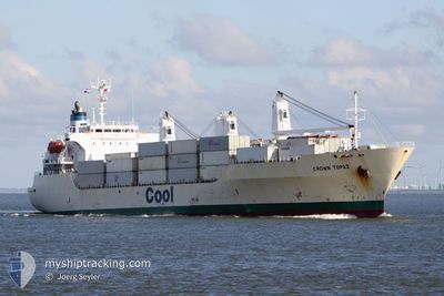
CROWN TOPAZ
Reefer

Current Trip
| Time Travelled | 2 days |
|---|---|
| Remaining Time | --- |
| Distance Travelled | 1346.28 nm |
| Remaining Distance | --- |
| AVG Speed | 18.9 Knopen |
| MAX Speed | 21.1 Knopen |
| AVG Wind | 13.4 knots |
| MAX Wind | 19 knots |
| MIN Temp | 18.4°C / 65.12°F |
| MAX Temp | 22.9°C / 73.22°F |
| Diepgang | 8 M |
| Positie ontvangen | 2 d geleden |
Current Position
| Lengtegraad | --- |
|---|---|
| Breedtegraat | --- |
| Status | Under way using engine |
| Snelheid | 19.3 Knopen |
| Koers | 316° |
| Gebied | South Atlantic Ocean |
| Station | T-AIS |
| Positie ontvangen | 2 d geleden |
Information
The current position of CROWN TOPAZ is in South Atlantic Ocean with coordinates -32.22556° / 16.43538° as reported on 2025-03-06 15:16 by AIS to our vessel tracker app. The vessel's current speed is 19.3 Knopen and is heading at the port of ST PETERSBURG. The estimated time of arrival as calculated by MyShipTracking vessel tracking app is 2025-03-25 01:00 LT
The vessel CROWN TOPAZ (IMO: 9191498, MMSI: 311000788) is a Reefer that was built in 1999 ( 26 Jaar oud ). It's sailing under the flag of [BS] Bahamas.
In this page you can find informations about the vessels current position, last detected port calls, and current voyage information. If the vessels is not in coverage by AIS you will find the latest position.
The current position of CROWN TOPAZ is detected by our AIS receivers and we are not responsible for the reliability of the data. The last position was recorded while the vessel was in Coverage by the Ais receivers of our vessel tracking app.
The current draught of CROWN TOPAZ as reported by AIS is 8 meters
Weather
| Temperature | 22.4°C / 72.32°F |
|---|---|
| Wind Speed | 13 knots |
| Direction | 145° SE |
| Pressure | 1012.8 hPa |
| Humidity | 84.8 % |
| Cloud Coverage | 100 % |


Featured Company
Last Port Calls
| Port | Arrival | Departure | Time In Port |
|---|---|---|---|
| 2025-02-28 19:36 | 2025-03-06 07:14 | 5 d | |
| 2025-02-13 05:42 | 2025-02-14 18:28 | 1 d | |
| 2025-02-10 03:44 | 2025-02-12 14:38 | 2 d | |
| 2025-02-05 05:19 | 2025-02-05 19:12 | 13 h | |
| 2025-01-23 19:33 | 2025-01-28 10:01 | 4 d | |
| 2025-01-15 16:26 | 2025-01-18 20:38 | 3 d |
Last Trips
| Origin | Departure | Destination | Arrival | Distance | |
|---|---|---|---|---|---|
| 2025-02-14 18:28 | 2025-02-28 21:36 | 6159.19 nm | |||
| 2025-02-12 15:38 | 2025-02-13 05:42 | 140.54 nm | |||
| 2025-02-05 20:12 | 2025-02-10 04:44 | 930.66 nm | |||
| 2025-01-28 07:01 | 2025-02-05 06:19 | 3300.74 nm | |||
| 2025-01-18 17:38 | 2025-01-23 16:33 | 2295.29 nm | |||
| 2024-12-28 13:29 | 2025-01-15 13:26 | 7751.46 nm |
Events
| Tijd | Evenement | Details | Positie / Bestemming | Info |
|---|---|---|---|---|
| 2025-03-06 15:23 | Status Changed | Default Under way using engine |
-32.19878 / 16.40501
RU LED
|
Snelheid: 19.3 kn Koers: 316° |
| 2025-03-06 15:16 | Status Changed | Under way using engine Default |
-32.22556 / 16.43538
RU LED
|
Snelheid: 19.2 kn Koers: 317° |
| 2025-03-06 15:16 | Buitenbereik |
-32.22556 / 16.43538
South Atlantic Ocean
RU LED
|
Snelheid: 19.3 kn Koers: 316° |
|
| 2025-03-06 15:12 | Binnenbereik |
-32.22556 / 16.43538
South Atlantic Ocean
RU LED
|
Snelheid: 19.3 kn Koers: 316° |
|
| 2025-03-06 14:09 | Status Changed | Default Under way using engine |
-32.48093 / 16.72919
RU LED
|
Snelheid: 19.5 kn Koers: 315° |
| 2025-03-06 14:05 | Buitenbereik |
-32.49729 / 16.74894
South Atlantic Ocean
RU LED
|
Snelheid: 19.5 kn Koers: 315° |
|
| 2025-03-06 14:04 | Status Changed | Under way using engine Default |
-32.49916 / 16.75121
RU LED
|
Snelheid: 19.5 kn Koers: 316° |
| 2025-03-06 14:04 | Binnenbereik |
-32.49729 / 16.74894
South Atlantic Ocean
RU LED
|
Snelheid: 19.5 kn Koers: 315° |
|
| 2025-03-06 12:20 | Status Changed | Default Under way using engine |
-32.90555 / 17.21706
RU LED
|
Snelheid: 19.6 kn Koers: 313° |
| 2025-03-06 12:12 | Buitenbereik |
-32.93467 / 17.25393
South Atlantic Ocean
RU LED
|
Snelheid: 19.6 kn Koers: 313° |