
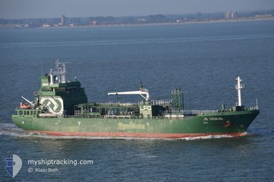
CHUKAR
Lpg Tanker
Current Trip
| Time Travelled | 2 days |
|---|---|
| Remaining Time | 22 h, 47 mins |
| Distance Travelled | 534.77 nm |
| Remaining Distance | 270.10 nm |
| AVG Speed | 8.9 Knopen |
| MAX Speed | 12 Knopen |
| AVG Wind | 16.7 knots |
| MAX Wind | 28 knots |
| MIN Temp | 12.9°C / 55.22°F |
| MAX Temp | 15.3°C / 59.54°F |
| Diepgang | 5.5 M |
| Positie ontvangen | 3 m geleden |
Current Position
| Lengtegraad | --- |
|---|---|
| Breedtegraat | --- |
| Status | Under way using engine |
| Snelheid | 11.3 Knopen |
| Koers | 39.5° |
| Gebied | English Channel |
| Station | T-AIS |
| Positie ontvangen | 3 m geleden |
Info
Information
The current position of CHUKAR is in English Channel with coordinates 51.09525° / 1.65397° as reported on 2024-10-27 11:28 by AIS to our vessel tracker app. The vessel's current speed is 11.3 Knopen and is heading at the port of TEES. The estimated time of arrival as calculated by MyShipTracking vessel tracking app is 2024-10-28 10:19 LT
The vessel CHUKAR (IMO: 9578000, MMSI: 249362000) is a Lpg Tanker that was built in 2012 ( 12 Jaar oud ). It's sailing under the flag of [MT] Malta.
In this page you can find informations about the vessels current position, last detected port calls, and current voyage information. If the vessels is not in coverage by AIS you will find the latest position.
The current position of CHUKAR is detected by our AIS receivers and we are not responsible for the reliability of the data. The last position was recorded while the vessel was in Coverage by the Ais receivers of our vessel tracking app.
The current draught of CHUKAR as reported by AIS is 5.5 meters
Weather
| Temperature | 13.3°C / 55.94°F |
|---|---|
| Wind Speed | 8 knots |
| Direction | 326° NW |
| Pressure | 1022.5 hPa |
| Humidity | 84.2 % |
| Cloud Coverage | 3 % |
Featured Company
Last Port Calls
| Port | Arrival | Departure | Time In Port |
|---|---|---|---|
| 2024-10-23 08:23 | 2024-10-24 23:17 | 1 d | |
| 2024-10-18 16:47 | 2024-10-19 19:04 | 1 d | |
| 2024-10-14 12:49 | 2024-10-15 14:47 | 1 d | |
| 2024-10-10 12:11 | 2024-10-11 12:51 | 1 d | |
| 2024-10-05 11:14 | 2024-10-06 14:10 | 1 d | |
| 2024-10-01 14:09 | 2024-10-02 11:41 | 21 h | |
| 2024-09-26 16:20 | 2024-09-27 16:22 | 1 d | |
| 2024-09-21 12:38 | 2024-09-22 10:21 | 21 h | |
| 2024-09-12 23:06 | 2024-09-15 02:47 | 2 d | |
| 2024-09-06 15:52 | 2024-09-07 16:33 | 1 d |
Last Trips
| Origin | Departure | Destination | Arrival | Distance | |
|---|---|---|---|---|---|
| 2024-10-19 20:04 | 2024-10-23 09:23 | 785.56 nm | |||
| 2024-10-15 15:47 | 2024-10-18 17:47 | 806.80 nm | |||
| 2024-10-11 13:51 | 2024-10-14 13:49 | 785.39 nm | |||
| 2024-10-06 15:10 | 2024-10-10 13:11 | 838.05 nm | |||
| 2024-10-02 12:41 | 2024-10-05 12:14 | 783.03 nm | |||
| 2024-09-27 18:22 | 2024-10-01 15:09 | 895.48 nm | |||
| 2024-09-22 11:21 | 2024-09-26 18:20 | 894.03 nm | |||
| 2024-09-15 04:47 | 2024-09-21 13:38 | 345.15 nm | |||
| 2024-09-07 17:33 | 2024-09-13 01:06 | 335.02 nm | |||
| 2024-09-04 01:54 | 2024-09-06 16:52 | 331.26 nm |
Events
| Tijd | Evenement | Details | Positie / Bestemming | Info |
|---|---|---|---|---|
| 2024-10-27 11:13 | Wijzig zee gebeid | United Kingdom part of the North Sea French part of the North Sea |
51.05858 / 1.60608
North Sea
GB TEE
|
Snelheid: 11.5 kn Koers: 42° |
| 2024-10-27 11:01 | Wijzig zee gebeid | French part of the North Sea French part of the English Channel |
51.03043 / 1.56448
North Sea
GB TEE
|
Snelheid: 11.6 kn Koers: 46° |
| 2024-10-27 08:25 | Binnenbereik |
50.59115 / 1.22750
English Channel
GB TEE
|
Snelheid: 11.3 kn Koers: 47.4° |
|
| 2024-10-27 06:58 | Buitenbereik |
50.44952 / .87497
English Channel
GB TEE
|
Snelheid: 11.3 kn Koers: 73.9° |
|
| 2024-10-27 06:58 | Gevonden in zee | French part of the English Channel |
50.44952 / .87497
English Channel
GB TEE
|
Snelheid: 11.3 kn Koers: 73.9° |
| 2024-10-27 01:54 | ETA Changed | 2024/10/28 13:00 2024/10/28 10:00 |
50.18543 / -.60857
GB TEE
|
Snelheid: 11.3 kn Koers: 74° |
| 2024-10-27 00:52 | Gevonden in zee | United Kingdom part of the English Channel |
50.13980 / -.89083
English Channel
GB TEE
|
Snelheid: 10.5 kn Koers: 77° |
| 2024-10-27 00:16 | Status Changed | Under way using engine Default |
50.11587 / -1.05147
GB TEE
|
Snelheid: 10 kn Koers: 78° |
| 2024-10-27 00:16 | Binnenbereik |
50.11587 / -1.05147
English Channel
GB TEE
|
Snelheid: 10.3 kn Koers: 76.2° |
|
| 2024-10-26 22:45 | Buitenbereik |
50.05825 / -1.43015
English Channel
GB TEE
|
Snelheid: 9.7 kn Koers: 74.2° |