
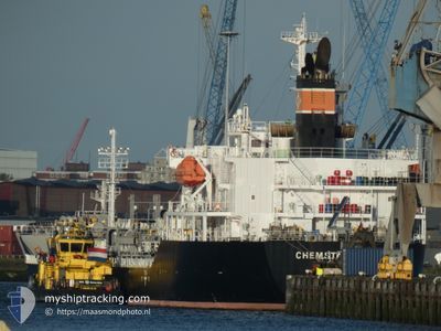
CHEMSTAR IRIS
Tanker
Current Trip
ID DUM
| Time Travelled | 4 days |
|---|---|
| Remaining Time | --- |
| Distance Travelled | 883.70 nm |
| Remaining Distance | --- |
| AVG Speed | 13 Knopen |
| MAX Speed | 15 Knopen |
| AVG Wind | 4.2 knots |
| MAX Wind | 8.9 knots |
| MIN Temp | 24.6°C / 76.28°F |
| MAX Temp | 31°C / 87.8°F |
| Diepgang | 5.9 M |
| Positie ontvangen | 7 d geleden |
Current Position
| Lengtegraad | 103.67638° |
|---|---|
| Breedtegraat | 1.17762° |
| Status | Under way using engine |
| Snelheid | 10.4 Knopen |
| Koers | 302.9° |
| Gebied | Singapore Strait |
| Station | T-AIS |
| Positie ontvangen | 7 d geleden |
Info
Information
The current position of CHEMSTAR IRIS is in Singapore Strait with coordinates 1.17762° / 103.67638° as reported on 2024-04-28 22:55 by AIS to our vessel tracker app. The vessel's current speed is 10.4 Knopen
The vessel CHEMSTAR IRIS (IMO: 9827463, MMSI: 372861000) is a Tanker It's sailing under the flag of [PA] Panama.
In this page you can find informations about the vessels current position, last detected port calls, and current voyage information. If the vessels is not in coverage by AIS you will find the latest position.
The current position of CHEMSTAR IRIS is detected by our AIS receivers and we are not responsible for the reliability of the data. The last position was recorded while the vessel was in Coverage by the Ais receivers of our vessel tracking app.
The current draught of CHEMSTAR IRIS as reported by AIS is 5.9 meters
Weather
| Temperature | 29.2°C / 84.56°F |
|---|---|
| Wind Speed | 8 knots |
| Direction | 284° WNW |
| Pressure | 1008.2 hPa |
| Humidity | 75.2 % |
| Cloud Coverage | 100 % |
Featured Company
Last Port Calls
Most Visited Ports (Last year)
| Port | Arrivals | |
|---|---|---|
| 2 | ||
| 2 | ||
| 2 | ||
| 2 | ||
| 1 | ||
| 1 |
Last Trips
| Origin | Departure | Destination | Arrival | Distance | |
|---|---|---|---|---|---|
| 2024-04-27 22:36 | 2024-04-30 01:36 | 218.32 nm | |||
| 2024-04-05 08:27 | 2024-04-26 13:38 | 4146.72 nm | |||
| 2024-04-03 23:14 | 2024-04-03 23:39 | 3.39 nm | |||
| 2024-03-07 01:39 | 2024-04-03 13:56 | 6086.09 nm | |||
| 2024-02-28 14:28 | 2024-03-04 10:49 | 1447.99 nm |
Events
| Tijd | Evenement | Details | Positie / Bestemming | Info |
|---|---|---|---|---|
| 2024-05-01 17:31 | Stop beweging | 6.25 nm, North West of DUMAI |
1.74952 / 101.37238
ID DUM
|
Snelheid: Koers: 327° |
| 2024-05-01 16:24 | Start beweging | 1.11 nm, North of DUMAI |
1.70697 / 101.45645
ID DUM
|
Snelheid: 4.7 kn Koers: 254° |
| 2024-05-01 10:00 | Stop beweging | 1.47 nm, North of DUMAI |
1.71302 / 101.45840
ID DUM
|
Snelheid: 0.3 kn Koers: 129° |
| 2024-05-01 09:24 | Start beweging |
1.69013 / 101.45197
[ID] DUMAI
|
Snelheid: 3.4 kn Koers: 53° |
|
| 2024-05-01 09:16 | Vertrekhaven |
|
1.71061 / 101.45744
ID DUM
|
Snelheid: 3.4 kn Koers: 53° |
| 2024-04-29 18:45 | Stop beweging |
1.68865 / 101.44880
[ID] DUMAI
|
Snelheid: Koers: 91° |
|
| 2024-04-29 18:36 | Aankomsthaven |
|
1.69031 / 101.44877
[ID] DUMAI
|
Snelheid: 2.5 kn Koers: 191° |
| 2024-04-29 18:20 | Start beweging | 0.66 nm, North East of DUMAI |
1.69784 / 101.46268
ID DUM
|
Snelheid: 4 kn Koers: 235° |
| 2024-04-29 13:58 | Stop beweging | 0.91 nm, North East of DUMAI |
1.69898 / 101.46784
ID DUM
|
Snelheid: 0.3 kn Koers: 290° |
| 2024-04-28 22:55 | Buitenbereik |
1.17762 / 103.67638
Singapore Strait
ID DUM
|
Snelheid: 10.4 kn Koers: 302.9° |