
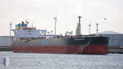
CATALAN SEA
Crude Oil Tanker
Current Trip
CAPTU
| Time Travelled | 10 days |
|---|---|
| Remaining Time | --- |
| Distance Travelled | 2543.03 nm |
| Remaining Distance | --- |
| AVG Speed | 11.8 Knopen |
| MAX Speed | 13.9 Knopen |
| AVG Wind | 10.3 knots |
| MAX Wind | 25.4 knots |
| MIN Temp | 10.3°C / 50.54°F |
| MAX Temp | 18.2°C / 64.76°F |
| Diepgang | 13.5 M |
| Positie ontvangen | 9 d geleden |
Current Position
| Lengtegraad | -1.56192° |
|---|---|
| Breedtegraat | 57.88079° |
| Status | Under way using engine |
| Snelheid | 12.9 Knopen |
| Koers | 358.8° |
| Gebied | North Sea |
| Station | T-AIS |
| Positie ontvangen | 9 d geleden |
Info
Information
The current position of CATALAN SEA is in North Sea with coordinates 57.88079° / -1.56192° as reported on 2024-09-02 15:55 by AIS to our vessel tracker app. The vessel's current speed is 12.9 Knopen
The vessel CATALAN SEA (IMO: 9577044, MMSI: 636016699) is a Crude Oil Tanker that was built in 2012 ( 12 Jaar oud ). It's sailing under the flag of [LR] Liberia.
In this page you can find informations about the vessels current position, last detected port calls, and current voyage information. If the vessels is not in coverage by AIS you will find the latest position.
The current position of CATALAN SEA is detected by our AIS receivers and we are not responsible for the reliability of the data. The last position was recorded while the vessel was in Coverage by the Ais receivers of our vessel tracking app.
The current draught of CATALAN SEA as reported by AIS is 13.5 meters
Weather
| Temperature | 15.2°C / 59.36°F |
|---|---|
| Wind Speed | 7 knots |
| Direction | 299° WNW |
| Pressure | 1022.3 hPa |
| Humidity | 80.8 % |
| Cloud Coverage | --- |
Featured Company
Last Port Calls
| Port | Arrival | Departure | Time In Port |
|---|---|---|---|
| 2024-08-31 11:32 | 2024-09-01 23:54 | 1 d | |
| 2024-08-24 13:10 | 2024-08-25 19:44 | 1 d | |
| 2024-08-22 07:17 | 2024-08-22 22:31 | 15 h | |
| 2024-08-13 04:27 | 2024-08-14 09:06 | 1 d | |
| 2024-07-24 05:36 | 2024-07-25 08:43 | 1 d | |
| 2024-07-18 07:39 | 2024-07-19 14:21 | 1 d |
Last Trips
| Origin | Departure | Destination | Arrival | Distance | |
|---|---|---|---|---|---|
| 2024-08-25 21:44 | 2024-08-31 12:32 | 368.57 nm | |||
| 2024-08-23 00:31 | 2024-08-24 15:10 | 314.15 nm | |||
| 2024-08-14 06:36 | 2024-08-22 09:17 | 2472.87 nm | |||
| 2024-07-25 09:43 | 2024-08-13 01:57 | 3090.89 nm | |||
| 2024-07-19 15:21 | 2024-07-24 06:36 | 220.34 nm | |||
| 2024-06-18 00:59 | 2024-07-18 08:39 | 1381.34 nm |
Events
| Tijd | Evenement | Details | Positie / Bestemming | Info |
|---|---|---|---|---|
| 2024-09-02 16:01 | Status Changed | Default Under way using engine |
57.90123 / -1.56316
CAPTU
|
Snelheid: 12.9 kn Koers: 358.8° |
| 2024-09-02 15:55 | Buitenbereik |
57.88079 / -1.56192
North Sea
CAPTU
|
Snelheid: 12.9 kn Koers: 358.8° |
|
| 2024-09-02 14:37 | Status Changed | Under way using engine Default |
57.61501 / -1.47126
CAPTU
|
Snelheid: 12.2 kn Koers: 348° |
| 2024-09-02 14:35 | Status Changed | Default Under way using engine |
57.60684 / -1.46775
CAPTU
|
Snelheid: 12.1 kn Koers: 349.2° |
| 2024-09-02 13:50 | Status Changed | Under way using engine Default |
57.46225 / -1.44226
CAPTU
|
Snelheid: 11.4 kn Koers: 359° |
| 2024-09-02 13:43 | Status Changed | Default Under way using engine |
57.43856 / -1.44135
CAPTU
|
Snelheid: 11.5 kn Koers: 359.4° |