
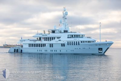
BELLA II
Yacht
Current Trip
| Time Travelled | 3 days |
|---|---|
| Remaining Time | --- |
| Distance Travelled | 73.52 nm |
| Remaining Distance | --- |
| AVG Speed | 9.5 Knopen |
| MAX Speed | 13 Knopen |
| AVG Wind | 16.4 knots |
| MAX Wind | 24 knots |
| MIN Temp | 23.5°C / 74.3°F |
| MAX Temp | 27.4°C / 81.32°F |
| Diepgang | 3.2 M |
| Positie ontvangen | 1 m geleden |
Current Position
| Lengtegraad | 25.15540° |
|---|---|
| Breedtegraat | 36.98161° |
| Status | At anchor |
| Snelheid | |
| Koers | 162° |
| Gebied | Aegean Sea |
| Station | T-AIS |
| Positie ontvangen | 1 m geleden |
Info
Information
The current position of BELLA II is in Aegean Sea with coordinates 36.98161° / 25.15540° as reported on 2024-09-09 23:37 by AIS to our vessel tracker app. The vessel's current speed is 0 Knopen
The vessel BELLA II (IMO: 9559286, MMSI: 538071319) is a Yacht that was built in 2008 ( 16 Jaar oud ). It's sailing under the flag of [MH] Marshall Is.
In this page you can find informations about the vessels current position, last detected port calls, and current voyage information. If the vessels is not in coverage by AIS you will find the latest position.
The current position of BELLA II is detected by our AIS receivers and we are not responsible for the reliability of the data. The last position was recorded while the vessel was in Coverage by the Ais receivers of our vessel tracking app.
The current draught of BELLA II as reported by AIS is 3.2 meters
Weather
| Temperature | 23.6°C / 74.48°F |
|---|---|
| Wind Speed | 4 knots |
| Direction | 194° SSW |
| Pressure | 1007.9 hPa |
| Humidity | 66 % |
| Cloud Coverage | 100 % |
Featured Company
Last Port Calls
| Port | Arrival | Departure | Time In Port |
|---|---|---|---|
| 2024-09-06 08:01 | 2024-09-06 08:12 | 11 m | |
| 2024-09-06 06:56 | 2024-09-06 07:18 | 21 m | |
| 2024-08-28 14:27 | 2024-09-03 09:02 | 5 d | |
| 2024-08-28 05:45 | 2024-08-28 12:34 | 6 h | |
| 2024-08-24 10:56 | 2024-08-28 02:17 | 3 d | |
| 2024-08-23 12:00 | 2024-08-24 07:11 | 19 h | |
| 2024-07-10 06:11 |
Most Visited Ports (Last year)
| Port | Arrivals | |
|---|---|---|
| 2 | ||
| 2 | ||
| 1 | ||
| 1 | ||
| 1 | ||
| 1 |
Last Trips
| Origin | Departure | Destination | Arrival | Distance | |
|---|---|---|---|---|---|
| 2024-09-06 10:18 | 2024-09-06 11:01 | 5.82 nm | |||
| 2024-09-03 12:02 | 2024-09-06 09:56 | 162.18 nm | |||
| 2024-08-28 15:34 | 2024-08-28 17:27 | 22.73 nm | |||
| 2024-08-28 05:17 | 2024-08-28 08:45 | 43.98 nm | |||
| 2024-08-24 10:11 | 2024-08-24 13:56 | 39.76 nm | |||
| 2024-07-10 09:11 | 2024-08-23 15:00 | 803.90 nm |
Events
| Tijd | Evenement | Details | Positie / Bestemming | Info |
|---|---|---|---|---|
| 2024-09-08 18:49 | Status Changed | At anchor Under way using engine |
36.98133 / 25.15587
PAROS
|
Snelheid: Koers: 343° |
| 2024-09-08 07:06 | Stop beweging | 4.31 nm, South East of POUNTA |
36.98159 / 25.15528
PAROS
|
Snelheid: 0.2 kn Koers: 59° |
| 2024-09-08 06:56 | Start beweging | 4.4 nm, South East of POUNTA |
36.97406 / 25.14472
PAROS
|
Snelheid: 6.2 kn Koers: 33.4° |
| 2024-09-08 06:50 | Stop beweging | 4.51 nm, South East of POUNTA |
36.97236 / 25.14568
PAROS
|
Snelheid: 0.3 kn Koers: 345° |
| 2024-09-08 04:33 | Start beweging | 6.55 nm, South East of IOS |
36.65076 / 25.37004
PAROS
|
Snelheid: 3.2 kn Koers: 257° |
| 2024-09-08 04:30 | Status Changed | Under way using engine At anchor |
36.65156 / 25.37107
PAROS
|
Snelheid: 0.4 kn Koers: 339° |
| 2024-09-08 04:30 | Destination Changed | PAROS IOS |
36.65170 / 25.37145
PAROS
|
Snelheid: 0.4 kn Koers: 339° |
| 2024-09-08 04:30 | ETA Changed | 2024/09/08 10:00 2024/09/07 10:00 |
36.65170 / 25.37145
PAROS
|
Snelheid: 0.4 kn Koers: 339° |
| 2024-09-07 06:10 | Status Changed | At anchor Under way using engine |
36.65357 / 25.37154
IOS
|
Snelheid: 0.7 kn Koers: 23° |
| 2024-09-07 06:09 | Stop beweging | 6.48 nm, South East of IOS |
36.65383 / 25.37159
IOS
|
Snelheid: 0.2 kn Koers: 20° |