
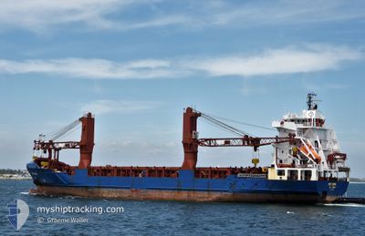
BBC ORION
General Cargo
Current Trip
| Trip Time | 8 days |
|---|---|
| Trip Distance | 1661.37 nm |
| AVG Speed | 11.6 Knopen |
| MAX Speed | 16.6 Knopen |
| Diepgang | 7.7 M |
| AVG Wind | 11.3 knots |
| MAX Wind | 22 knots |
| MIN Temp | -0.7°C / 30.74°F |
| MAX Temp | 17.1°C / 62.78°F |
| Positie ontvangen | 1 m geleden |
Current Position
| Lengtegraad | -73.12040° |
|---|---|
| Breedtegraat | 46.04635° |
| Status | Moored |
| Snelheid | |
| Koers | 354° |
| Gebied | Gulf of St-Lawrence |
| Station | T-AIS |
| Positie ontvangen | 1 m geleden |
Info
Information
The current position of BBC ORION is in Gulf of St-Lawrence with coordinates 46.04635° / -73.12040° as reported on 2024-05-04 03:14 by AIS to our vessel tracker app. The vessel's current speed is 0 Knopen and is currently inside the port of SOREL.
The vessel BBC ORION (IMO: 9347841, MMSI: 304127000) is a General Cargo that was built in 2007 ( 17 Jaar oud ). It's sailing under the flag of [AG] Antigua Barbuda.
In this page you can find informations about the vessels current position, last detected port calls, and current voyage information. If the vessels is not in coverage by AIS you will find the latest position.
The current position of BBC ORION is detected by our AIS receivers and we are not responsible for the reliability of the data. The last position was recorded while the vessel was in Coverage by the Ais receivers of our vessel tracking app.
The current draught of BBC ORION as reported by AIS is 7.7 meters
Weather
| Temperature | 9.8°C / 49.64°F |
|---|---|
| Wind Speed | 9 knots |
| Direction | 38° NE |
| Pressure | 1022.7 hPa |
| Humidity | 79 % |
| Cloud Coverage | 98 % |
Featured Company
Last Trips
| Origin | Departure | Destination | Arrival | Distance | |
|---|---|---|---|---|---|
| 2024-04-25 12:58 | 2024-05-03 19:54 | 1661.37 nm | |||
| 2024-04-22 16:11 | 2024-04-24 17:29 | 594.60 nm | |||
| 2024-03-21 12:31 | 2024-04-19 12:40 | 6898.69 nm | |||
| 2024-03-03 08:59 | 2024-03-20 20:48 | 5562.50 nm |
Events
| Tijd | Evenement | Details | Positie / Bestemming | Info |
|---|---|---|---|---|
| 2024-05-04 00:11 | Status Changed | Moored Under way using engine |
46.04629 / -73.12044
[CA] SOREL
|
Snelheid: Koers: 354° |
| 2024-05-03 23:59 | Stop beweging |
46.04746 / -73.12031
[CA] SOREL
|
Snelheid: 0.3 kn Koers: 1° |
|
| 2024-05-03 23:54 | Aankomsthaven |
|
46.04807 / -73.12008
[CA] SOREL
|
Snelheid: 0.6 kn Koers: 12° |
| 2024-05-03 23:27 | Start beweging | 0.56 nm, North East of SOREL |
46.05526 / -73.10541
SOREL ANCHORAGE
|
Snelheid: 3.1 kn Koers: 242° |
| 2024-05-03 23:23 | Status Changed | Under way using engine At anchor |
46.05614 / -73.10276
SOREL ANCHORAGE
|
Snelheid: 0.7 kn Koers: 243° |
| 2024-05-03 07:14 | Status Changed | At anchor Under way using engine |
46.05665 / -73.10314
SOREL ANCHORAGE
|
Snelheid: 0.3 kn Koers: 229° |
| 2024-05-03 07:13 | Stop beweging | 0.68 nm, North East of SOREL |
46.05674 / -73.10319
SOREL ANCHORAGE
|
Snelheid: 0.3 kn Koers: 235° |
| 2024-05-03 05:12 | ETA Changed | 2024/05/03 07:00 2024/05/03 05:00 |
46.24328 / -72.74954
SOREL ANCHORAGE
|
Snelheid: 11.9 kn Koers: 236.6° |
| 2024-05-03 04:45 | Status Changed | Under way using engine Default |
46.26706 / -72.63696
SOREL ANCHORAGE
|
Snelheid: 10.9 kn Koers: 233° |
| 2024-05-03 04:26 | Binnenbereik |
46.26679 / -72.63784
Gulf of St-Lawrence
SOREL ANCHORAGE
|
Snelheid: 10.7 kn Koers: 246.7° |