
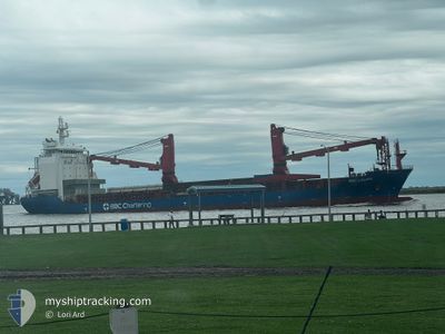
BBC LOUISE
Cargo
Current Trip
| Time Travelled | 12 h, 25 mins |
|---|---|
| Remaining Time | 1 day |
| Distance Travelled | 147.74 nm |
| Remaining Distance | 449.77 nm |
| AVG Speed | 13.1 Knopen |
| MAX Speed | 14.4 Knopen |
| AVG Wind | 13.3 knots |
| MAX Wind | 19 knots |
| MIN Temp | 8°C / 46.4°F |
| MAX Temp | 19.8°C / 67.64°F |
| Diepgang | 6.5 M |
| Positie ontvangen | 10 h, 55 m geleden |
Current Position
| Lengtegraad | --- |
|---|---|
| Breedtegraat | --- |
| Status | Under way using engine |
| Snelheid | 12.7 Knopen |
| Koers | 86.7° |
| Gebied | Gulf of Mexico |
| Station | T-AIS |
| Positie ontvangen | 10 h, 55 m geleden |
Info
Information
The current position of BBC LOUISE is in Gulf of Mexico with coordinates 29.34287° / -94.76074° as reported on 2025-01-14 12:02 by AIS to our vessel tracker app. The vessel's current speed is 12.7 Knopen and is heading at the port of ALTAMIRA. The estimated time of arrival as calculated by MyShipTracking vessel tracking app is 2025-01-15 23:50 LT
The vessel BBC LOUISE (IMO: 9685097, MMSI: 304617000) is a Cargo It's sailing under the flag of [AG] Antigua Barbuda.
In this page you can find informations about the vessels current position, last detected port calls, and current voyage information. If the vessels is not in coverage by AIS you will find the latest position.
The current position of BBC LOUISE is detected by our AIS receivers and we are not responsible for the reliability of the data. The last position was recorded while the vessel was in Coverage by the Ais receivers of our vessel tracking app.
The current draught of BBC LOUISE as reported by AIS is 6.5 meters
Weather
| Temperature | 19.7°C / 67.46°F |
|---|---|
| Wind Speed | 18 knots |
| Direction | 89° E |
| Pressure | 1023.4 hPa |
| Humidity | 72.3 % |
| Cloud Coverage | 95 % |
Featured Company
Last Port Calls
| Port | Arrival | Departure | Time In Port |
|---|---|---|---|
| 2025-01-12 22:14 | 2025-01-14 10:32 | 1 d | |
| 2025-01-06 16:17 | 2025-01-07 08:46 | 16 h | |
| 2024-12-20 14:50 | 2024-12-21 22:47 | 1 d | |
| 2024-11-04 15:52 | 2024-11-05 08:24 | 16 h | |
| 2024-11-01 16:28 |
Most Visited Ports (Last year)
| Port | Arrivals | |
|---|---|---|
| 3 | ||
| 2 | ||
| 2 | ||
| 2 | ||
| 2 | ||
| 2 |
Last Trips
| Origin | Departure | Destination | Arrival | Distance | |
|---|---|---|---|---|---|
| 2025-01-07 04:46 | 2025-01-12 16:14 | 1729.51 nm | |||
| 2024-12-21 16:47 | 2025-01-06 12:17 | 3110.87 nm | |||
| 2024-11-05 15:24 | 2024-12-20 08:50 | 11139.78 nm | |||
| 2024-11-01 23:28 | 2024-11-04 22:52 | 9.86 nm |
Events
| Tijd | Evenement | Details | Positie / Bestemming | Info |
|---|---|---|---|---|
| 2025-01-14 12:07 | Status Changed | Default Under way using engine |
29.34394 / -94.74070
MX ATM
|
Snelheid: 12.7 kn Koers: 86.7° |
| 2025-01-14 12:02 | Buitenbereik |
29.34287 / -94.76074
Gulf of Mexico
MX ATM
|
Snelheid: 12.7 kn Koers: 86.7° |
|
| 2025-01-14 11:59 | Status Changed | Under way using engine Default |
29.34349 / -94.77206
MX ATM
|
Snelheid: 13.2 kn Koers: 142° |
| 2025-01-14 11:51 | Status Changed | Default Under way using engine |
29.36324 / -94.79778
MX ATM
|
Snelheid: 12.8 kn Koers: 156.3° |
| 2025-01-14 10:32 | Vertrekhaven |
|
29.59058 / -94.93993
MX ATM
|
Snelheid: 12.5 kn Koers: 146° |
| 2025-01-14 07:34 | Start beweging |
29.71675 / -95.24497
[US] HOUSTON
|
Snelheid: 3.5 kn Koers: 53° |
|
| 2025-01-14 07:28 | Status Changed | Under way using engine Moored |
29.71554 / -95.24688
[US] HOUSTON
|
Snelheid: Koers: 52° |
| 2025-01-14 07:22 | Destination Changed | MX ATM US HOU |
29.71556 / -95.24688
[US] HOUSTON
|
Snelheid: Koers: 52° |
| 2025-01-14 07:22 | ETA Changed | 2025/01/15 16:00 2025/01/12 19:30 |
29.71556 / -95.24688
[US] HOUSTON
|
Snelheid: Koers: 52° |
| 2025-01-14 07:17 | Status Changed | Moored Default |
29.71559 / -95.24688
[US] HOUSTON
|
Snelheid: Koers: 52° |