
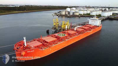
BALEEN
Tanker D
Current Trip
| Time Travelled | 18 days |
|---|---|
| Remaining Time | --- |
| Distance Travelled | 4451.58 nm |
| Remaining Distance | --- |
| AVG Speed | 10.7 Knopen |
| MAX Speed | 14.1 Knopen |
| AVG Wind | 11.9 knots |
| MAX Wind | 19.3 knots |
| MIN Temp | 24.8°C / 76.64°F |
| MAX Temp | 31.5°C / 88.7°F |
| Diepgang | 12.2 M |
| Positie ontvangen | 8 d geleden |
Current Position
| Lengtegraad | -61.80191° |
|---|---|
| Breedtegraat | 10.65073° |
| Status | Under way using engine |
| Snelheid | 10.5 Knopen |
| Koers | 335.9° |
| Gebied | Caribbean Sea |
| Station | T-AIS |
| Positie ontvangen | 8 d geleden |
Info
Information
The current position of BALEEN is in Caribbean Sea with coordinates 10.65073° / -61.80191° as reported on 2024-05-29 04:28 by AIS to our vessel tracker app. The vessel's current speed is 10.5 Knopen and is heading at the port of TRAMANDAI. The estimated time of arrival as calculated by MyShipTracking vessel tracking app is 2024-06-10 08:00 LT
The vessel BALEEN (IMO: 9855367, MMSI: 538008771) is a Tanker D It's sailing under the flag of [MH] Marshall Is.
In this page you can find informations about the vessels current position, last detected port calls, and current voyage information. If the vessels is not in coverage by AIS you will find the latest position.
The current position of BALEEN is detected by our AIS receivers and we are not responsible for the reliability of the data. The last position was recorded while the vessel was in Coverage by the Ais receivers of our vessel tracking app.
The current draught of BALEEN as reported by AIS is 12.2 meters
Weather
| Temperature | 27.7°C / 81.86°F |
|---|---|
| Wind Speed | 13 knots |
| Direction | 135° SE |
| Pressure | 1015.9 hPa |
| Humidity | 74.7 % |
| Cloud Coverage | 42 % |
Featured Company
Last Port Calls
| Port | Arrival | Departure | Time In Port |
|---|---|---|---|
| 2024-05-18 18:51 | 2024-05-19 17:05 | 22 h | |
| 2024-05-12 19:14 | 2024-05-12 20:26 | 1 h | |
| 2024-05-07 12:09 | 2024-05-11 16:57 | 4 d |
Last Trips
| Origin | Departure | Destination | Arrival | Distance | |
|---|---|---|---|---|---|
| 2024-05-12 15:26 | 2024-05-18 13:51 | 193.91 nm | |||
| 2024-05-11 11:57 | 2024-05-12 14:14 | 215.09 nm | |||
| 2024-03-25 23:52 | 2024-05-07 07:09 | 5478.53 nm |
Events
| Tijd | Evenement | Details | Positie / Bestemming | Info |
|---|---|---|---|---|
| 2024-05-29 04:35 | Status Changed | Default Under way using engine |
10.66937 / -61.79636
BR TRM
|
Snelheid: 10.5 kn Koers: 335.9° |
| 2024-05-29 04:28 | Buitenbereik |
10.65073 / -61.80191
Caribbean Sea
BR TRM
|
Snelheid: 10.5 kn Koers: 335.9° |
|
| 2024-05-29 02:56 | Destination Changed | BR TRM TT POS |
10.63379 / -61.64270
BR TRM
|
Snelheid: 6.3 kn Koers: 258.4° |
| 2024-05-29 02:56 | ETA Changed | 2024/06/10 08:00 2024/06/28 14:30 |
10.63379 / -61.64270
BR TRM
|
Snelheid: 6.3 kn Koers: 258.4° |
| 2024-05-29 02:46 | Start beweging | 2.37 nm, South of CHAGUARAMAS |
10.63656 / -61.62942
TT POS
|
Snelheid: 3.1 kn Koers: 261° |
| 2024-05-29 02:32 | Status Changed | Under way using engine At anchor |
10.63387 / -61.62631
TT POS
|
Snelheid: 0.1 kn Koers: 17° |
| 2024-05-29 00:58 | Status Changed | At anchor Default |
10.63375 / -61.62488
TT POS
|
Snelheid: Koers: -1° |
| 2024-05-29 00:44 | Status Changed | Default At anchor |
10.63333 / -61.62500
TT POS
|
Snelheid: Koers: 6° |
| 2024-05-28 23:22 | Status Changed | At anchor Default |
10.63413 / -61.62416
TT POS
|
Snelheid: Koers: 346° |
| 2024-05-28 22:50 | Status Changed | Default At anchor |
10.63500 / -61.62333
TT POS
|
Snelheid: Koers: 342° |