

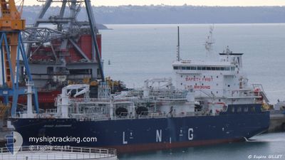
AVENIR ACHIEVEMENT
Tanker

Current Trip
| Time Travelled | 21 days |
|---|---|
| Remaining Time | --- |
| Distance Travelled | 3287.14 nm |
| Remaining Distance | --- |
| AVG Speed | 12 Knopen |
| MAX Speed | 15.1 Knopen |
| AVG Wind | 9.8 knots |
| MAX Wind | 24 knots |
| MIN Temp | 20°C / 68°F |
| MAX Temp | 29.4°C / 84.92°F |
| Diepgang | 7 M |
| Positie ontvangen | 6 h, 1 m geleden |
Current Position
| Lengtegraad | --- |
|---|---|
| Breedtegraat | --- |
| Status | Under way using engine |
| Snelheid | 10 Knopen |
| Koers | 169.3° |
| Gebied | North Atlantic Ocean |
| Station | T-AIS |
| Positie ontvangen | 6 h, 1 m geleden |
Information
The current position of AVENIR ACHIEVEMENT is in North Atlantic Ocean with coordinates 25.88942° / -79.48991° as reported on 2025-02-15 03:10 by AIS to our vessel tracker app. The vessel's current speed is 10 Knopen
The vessel AVENIR ACHIEVEMENT (MMSI: 319205300) is a Tanker It's sailing under the flag of [KY] Cayman Is.
In this page you can find informations about the vessels current position, last detected port calls, and current voyage information. If the vessels is not in coverage by AIS you will find the latest position.
The current position of AVENIR ACHIEVEMENT is detected by our AIS receivers and we are not responsible for the reliability of the data. The last position was recorded while the vessel was in Coverage by the Ais receivers of our vessel tracking app.
The current draught of AVENIR ACHIEVEMENT as reported by AIS is 7 meters
Weather
| Temperature | 24.2°C / 75.56°F |
|---|---|
| Wind Speed | 17 knots |
| Direction | 95° E |
| Pressure | 1021.7 hPa |
| Humidity | 77.1 % |
| Cloud Coverage | --- |


Featured Company
Last Port Calls
| Port | Arrival | Departure | Time In Port |
|---|---|---|---|
| 2025-01-24 18:43 | 2025-01-24 18:55 | 12 m | |
| 2025-01-23 10:35 | 2025-01-24 04:51 | 18 h | |
| 2025-01-23 04:23 | 2025-01-23 04:35 | 12 m | |
| 2025-01-21 14:34 | 2025-01-22 12:38 | 22 h | |
| 2025-01-17 19:27 | 2025-01-17 19:35 | 8 m | |
| 2025-01-16 21:15 | 2025-01-17 12:27 | 15 h | |
| 2025-01-16 15:51 | 2025-01-16 16:07 | 15 m | |
| 2025-01-03 21:19 | 2025-01-03 21:27 | 8 m | |
| 2025-01-03 07:35 | 2025-01-03 18:55 | 11 h | |
| 2025-01-02 16:03 | 2025-01-02 16:15 | 12 m |
Most Visited Ports (Last year)
| Port | Arrivals | |
|---|---|---|
| 56 | ||
| 13 | ||
| 1 | ||
| 1 |
Last Trips
| Origin | Departure | Destination | Arrival | Distance | |
|---|---|---|---|---|---|
| 2025-01-23 23:51 | 2025-01-24 13:43 | 5.54 nm | |||
| 2025-01-22 23:35 | 2025-01-23 05:35 | 2.40 nm | |||
| 2025-01-22 07:38 | 2025-01-22 23:23 | 167.79 nm | |||
| 2025-01-17 14:35 | 2025-01-21 09:34 | 1018.67 nm | |||
| 2025-01-17 07:27 | 2025-01-17 14:27 | 6.15 nm | |||
| 2025-01-16 11:07 | 2025-01-16 16:15 | 1.54 nm | |||
| 2025-01-03 16:27 | 2025-01-16 10:51 | 3001.21 nm | |||
| 2025-01-03 13:55 | 2025-01-03 16:19 | 1.51 nm | |||
| 2025-01-02 11:15 | 2025-01-03 02:35 | 4.54 nm | |||
| 2024-12-31 09:33 | 2025-01-02 11:03 | 574.89 nm |
Events
| Tijd | Evenement | Details | Positie / Bestemming | Info |
|---|---|---|---|---|
| 2025-02-15 03:15 | Status Changed | Default Under way using engine |
25.87756 / -79.48733
BS FPO
|
Snelheid: 10 kn Koers: 169.3° |
| 2025-02-15 03:10 | Status Changed | Under way using engine Default |
25.88942 / -79.48991
BS FPO
|
Snelheid: 9.9 kn Koers: 170° |
| 2025-02-15 03:10 | Buitenbereik |
25.88942 / -79.48991
North Atlantic Ocean
|
Snelheid: 10 kn Koers: 169.3° |
|
| 2025-02-15 02:53 | Binnenbereik |
25.88942 / -79.48991
North Atlantic Ocean
|
Snelheid: 10 kn Koers: 169.3° |
|
| 2025-02-14 22:11 | Start beweging | 2.1 nm, West of FREEPORT (BS) |
26.51650 / -78.81255
BS FPO
|
Snelheid: 5.1 kn Koers: 210° |
| 2025-02-14 07:23 | Stop beweging | 1.94 nm, West of FREEPORT (BS) |
26.52483 / -78.81020
BS FPO
|
Snelheid: 0.3 kn Koers: 165° |
| 2025-02-14 04:27 | Start beweging |
26.70986 / -79.19254
BS FPO
|
Snelheid: 5.7 kn Koers: 149° |
|
| 2025-02-12 19:15 | Stop beweging | 17.03 nm, South West of FREEPORT (BS) |
26.38257 / -79.04920
BS FPO
|
Snelheid: 0.3 kn Koers: 166° |
| 2025-02-12 17:31 | Start beweging | 2.01 nm, West of FREEPORT (BS) |
26.52150 / -78.81146
BS FPO
|
Snelheid: 5.1 kn Koers: 221° |
| 2025-02-11 13:27 | Stop beweging | 2.41 nm, West of FREEPORT (BS) |
26.51317 / -78.81757
BS FPO
|
Snelheid: 0.3 kn Koers: 65° |