
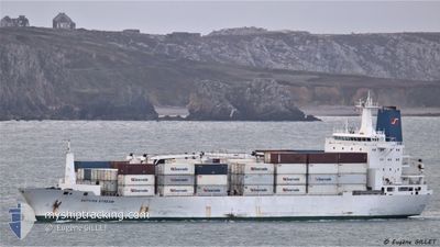
AUTUMN STREAM
Reefer
Current Trip
| Time Travelled | 29 days |
|---|---|
| Remaining Time | --- |
| Distance Travelled | 9006.89 nm |
| Remaining Distance | --- |
| AVG Speed | 15 Knopen |
| MAX Speed | 20.3 Knopen |
| AVG Wind | 10.8 knots |
| MAX Wind | 28.5 knots |
| MIN Temp | -4.1°C / 24.62°F |
| MAX Temp | 31.1°C / 87.98°F |
| Diepgang | 7.8 M |
| Positie ontvangen | 5 d geleden |
Current Position
| Lengtegraad | --- |
|---|---|
| Breedtegraat | --- |
| Status | Under way using engine |
| Snelheid | 19.2 Knopen |
| Koers | 178.7° |
| Gebied | North Pacific Ocean |
| Station | T-AIS |
| Positie ontvangen | 5 d geleden |
Info
Information
The current position of AUTUMN STREAM is in North Pacific Ocean with coordinates 8.46503° / -79.45521° as reported on 2025-02-12 08:40 by AIS to our vessel tracker app. The vessel's current speed is 19.2 Knopen and is heading at the port of CRISTOBAL. The estimated time of arrival as calculated by MyShipTracking vessel tracking app is 2025-02-11 01:00 LT
The vessel AUTUMN STREAM (IMO: 9038323, MMSI: 308315000) is a Reefer that was built in 1993 ( 32 Jaar oud ). It's sailing under the flag of [BS] Bahamas.
In this page you can find informations about the vessels current position, last detected port calls, and current voyage information. If the vessels is not in coverage by AIS you will find the latest position.
The current position of AUTUMN STREAM is detected by our AIS receivers and we are not responsible for the reliability of the data. The last position was recorded while the vessel was in Coverage by the Ais receivers of our vessel tracking app.
The current draught of AUTUMN STREAM as reported by AIS is 7.8 meters
Weather
| Temperature | 16.5°C / 61.7°F |
|---|---|
| Wind Speed | 21 knots |
| Direction | 187° S |
| Pressure | 1014 hPa |
| Humidity | 81.7 % |
| Cloud Coverage | --- |
Featured Company
Last Port Calls
| Port | Arrival | Departure | Time In Port |
|---|---|---|---|
| 2025-01-09 23:25 | 2025-01-19 03:13 | 9 d | |
| 2024-12-23 10:22 | 2024-12-24 07:20 | 20 h | |
| 2024-12-13 06:19 | 2024-12-13 17:03 | 10 h | |
| 2024-12-11 07:16 | 2024-12-12 21:00 | 1 d | |
| 2024-12-06 22:15 | 2024-12-09 19:47 | 2 d | |
| 2024-12-03 19:18 | 2024-12-04 14:57 | 19 h |
Most Visited Ports (Last year)
| Port | Arrivals | |
|---|---|---|
| 6 | ||
| 4 | ||
| 4 | ||
| 3 | ||
| 3 | ||
| 2 |
Last Trips
| Origin | Departure | Destination | Arrival | Distance | |
|---|---|---|---|---|---|
| 2024-12-24 07:20 | 2025-01-09 23:25 | 3850.70 nm | |||
| 2024-12-13 17:03 | 2024-12-23 10:22 | 4058.86 nm | |||
| 2024-12-12 21:00 | 2024-12-13 06:19 | 97.03 nm | |||
| 2024-12-09 19:47 | 2024-12-11 07:16 | 149.86 nm | |||
| 2024-12-04 14:57 | 2024-12-06 22:15 | 910.70 nm | |||
| 2024-11-25 12:09 | 2024-12-03 19:18 | 3264.14 nm |
Events
| Tijd | Evenement | Details | Positie / Bestemming | Info |
|---|---|---|---|---|
| 2025-02-12 08:45 | Status Changed | Default Under way using engine |
8.44191 / -79.45481
PACTB
|
Snelheid: 19.2 kn Koers: 178.7° |
| 2025-02-12 08:40 | Buitenbereik |
8.46503 / -79.45521
North Pacific Ocean
|
Snelheid: 19.2 kn Koers: 178.7° |
|
| 2025-02-12 07:56 | Status Changed | Under way using engine Default |
8.70246 / -79.45745
PACTB
|
Snelheid: 18.6 kn Koers: 180° |
| 2025-02-12 07:47 | Status Changed | Default Under way using engine |
8.74852 / -79.45689
PACTB
|
Snelheid: 16.5 kn Koers: 181° |
| 2025-02-12 07:22 | Status Changed | Under way using engine Default |
8.83796 / -79.48082
PACTB
|
Snelheid: 10.5 kn Koers: 143° |
| 2025-02-12 07:19 | Status Changed | Default Under way using engine |
8.84477 / -79.48607
PACTB
|
Snelheid: 12.7 kn Koers: 140° |
| 2025-02-12 07:14 | Status Changed | Under way using engine Default |
8.85758 / -79.49644
PACTB
|
Snelheid: 12.7 kn Koers: 141° |
| 2025-02-12 07:07 | Status Changed | Default Under way using engine |
8.87643 / -79.51197
PACTB
|
Snelheid: 11.5 kn Koers: 141.2° |
| 2025-02-12 06:56 | Gevonden in zee | Panamanian part of the North Pacific Ocean |
8.90529 / -79.53529
North Pacific Ocean
|
Snelheid: 7.3 kn Koers: 142.5° |
| 2025-02-12 06:56 | Status Changed | Under way using engine Default |
8.90529 / -79.53529
PACTB
|
Snelheid: 7 kn Koers: 143° |