
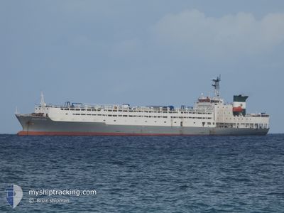
ATLANTIC ROSE
Reefer
Current Trip
| Time Travelled | 19 days |
|---|---|
| Remaining Time | --- |
| Distance Travelled | 5316.89 nm |
| Remaining Distance | --- |
| AVG Speed | 13 Knopen |
| MAX Speed | 17.5 Knopen |
| AVG Wind | 12.4 knots |
| MAX Wind | 28 knots |
| MIN Temp | 12.5°C / 54.5°F |
| MAX Temp | 28.2°C / 82.76°F |
| Diepgang | 7.5 M |
| Positie ontvangen | 3 h, 30 m geleden |
Current Position
| Lengtegraad | --- |
|---|---|
| Breedtegraat | --- |
| Status | Under way using engine |
| Snelheid | 15 Knopen |
| Koers | 53.1° |
| Gebied | South Atlantic Ocean |
| Station | T-AIS |
| Positie ontvangen | 3 h, 30 m geleden |
Info
Information
The current position of ATLANTIC ROSE is in South Atlantic Ocean with coordinates -32.11206° / -51.72271° as reported on 2024-10-03 11:56 by AIS to our vessel tracker app. The vessel's current speed is 15 Knopen
The vessel ATLANTIC ROSE (IMO: 8806242, MMSI: 511100124) is a Reefer that was built in 1989 ( 35 Jaar oud ). It's sailing under the flag of [PW] Palau.
In this page you can find informations about the vessels current position, last detected port calls, and current voyage information. If the vessels is not in coverage by AIS you will find the latest position.
The current position of ATLANTIC ROSE is detected by our AIS receivers and we are not responsible for the reliability of the data. The last position was recorded while the vessel was in Coverage by the Ais receivers of our vessel tracking app.
The current draught of ATLANTIC ROSE as reported by AIS is 7.5 meters
Weather
| Temperature | 14.5°C / 58.1°F |
|---|---|
| Wind Speed | 11 knots |
| Direction | 177° S |
| Pressure | 1024.3 hPa |
| Humidity | 56.7 % |
| Cloud Coverage | 1 % |
Featured Company
Last Port Calls
| Port | Arrival | Departure | Time In Port |
|---|---|---|---|
| 2024-09-13 06:20 | 2024-09-13 17:59 | 11 h | |
| 2024-09-04 05:22 | 2024-09-05 16:29 | 1 d | |
| 2024-08-17 11:08 | 2024-08-19 11:28 | 2 d |
Most Visited Ports (Last year)
| Port | Arrivals | |
|---|---|---|
| 7 | ||
| 5 | ||
| 5 | ||
| 1 | ||
| 1 | ||
| 1 |
Last Trips
| Origin | Departure | Destination | Arrival | Distance | |
|---|---|---|---|---|---|
| 2024-09-05 18:29 | 2024-09-13 08:20 | 1807.87 nm | |||
| 2024-08-19 08:28 | 2024-09-04 07:22 | 5254.61 nm | |||
| 2024-07-31 20:42 | 2024-08-17 08:08 | 3575.68 nm |
Events
| Tijd | Evenement | Details | Positie / Bestemming | Info |
|---|---|---|---|---|
| 2024-10-03 12:04 | Status Changed | Default Under way using engine |
-32.09273 / -51.69243
BR_RIG
|
Snelheid: 15 kn Koers: 53.1° |
| 2024-10-03 11:56 | Buitenbereik |
-32.11206 / -51.72271
South Atlantic Ocean
|
Snelheid: 15 kn Koers: 53.1° |
|
| 2024-10-03 11:35 | Status Changed | Under way using engine Default |
-32.16801 / -51.80600
BR_RIG
|
Snelheid: 14.7 kn Koers: 54° |
| 2024-10-03 11:35 | Binnenbereik |
-32.16403 / -51.80015
South Atlantic Ocean
|
Snelheid: 15.1 kn Koers: 51.3° |
|
| 2024-10-03 09:54 | Start beweging | 4.19 nm, South of RIO GRANDE |
-32.09725 / -52.09916
BR_RIG
|
Snelheid: 4.7 kn Koers: 159° |
| 2024-09-30 23:11 | Stop beweging | 3.99 nm, South of RIO GRANDE |
-32.09366 / -52.10075
BR_RIG
|
Snelheid: 0.1 kn Koers: 15° |
| 2024-09-30 21:19 | Start beweging | 18.05 nm, South of RIO GRANDE |
-32.32928 / -52.06625
BR_RIG
|
Snelheid: 4 kn Koers: 18° |
| 2024-09-30 15:55 | Status Changed | Default At anchor |
-32.33147 / -52.06637
BR_RIG
|
Snelheid: 0.3 kn Koers: 4° |
| 2024-09-30 15:52 | Status Changed | At anchor Default |
-32.33147 / -52.06632
BR_RIG
|
Snelheid: 0.2 kn Koers: 8° |
| 2024-09-30 15:52 | Buitenbereik |
-32.33147 / -52.06632
South Atlantic Ocean
|
Snelheid: 0.3 kn Koers: 273.7° |