
ATIRAM
Cargo
Current Trip
| Trip Time | 11 days |
|---|---|
| Trip Distance | 416.59 nm |
| AVG Speed | 7.7 Knopen |
| MAX Speed | 12.3 Knopen |
| Diepgang | 2.5 M |
| AVG Wind | 8 knots |
| MAX Wind | 12.8 knots |
| MIN Temp | -2.1°C / 28.22°F |
| MAX Temp | 5.8°C / 42.44°F |
| Positie ontvangen | 11 h, 2 m geleden |
Current Position
| Lengtegraad | --- |
|---|---|
| Breedtegraat | --- |
| Status | Under way using engine |
| Snelheid | 0.2 Knopen |
| Koers | 297° |
| Gebied | North Sea |
| Station | T-AIS |
| Positie ontvangen | 11 h, 2 m geleden |
Info
Information
The current position of ATIRAM is in North Sea with coordinates 51.97134° / 5.30849° as reported on 2025-02-16 11:22 by AIS to our vessel tracker app. The vessel's current speed is 0.2 Knopen and is currently inside the port of WIJK BIJ DUURSTEDE.
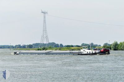
The vessel ATIRAM (MMSI: 244690665) is a Cargo It's sailing under the flag of [NL] Netherlands.
In this page you can find informations about the vessels current position, last detected port calls, and current voyage information. If the vessels is not in coverage by AIS you will find the latest position.
The current position of ATIRAM is detected by our AIS receivers and we are not responsible for the reliability of the data. The last position was recorded while the vessel was in Coverage by the Ais receivers of our vessel tracking app.
The current draught of ATIRAM as reported by AIS is 2.5 meters
Weather
| Temperature | -2.1°C / 28.22°F |
|---|---|
| Wind Speed | 6 knots |
| Direction | 76° ENE |
| Pressure | 1025.3 hPa |
| Humidity | 76.5 % |
| Cloud Coverage | 2 % |
Featured Company
Last Port Calls
| Port | Arrival | Departure | Time In Port |
|---|---|---|---|
| 2025-02-16 10:56 | |||
| 2025-02-05 10:54 | |||
| 2025-02-01 11:41 | 2025-02-01 13:14 | 1 h | |
| 2025-01-30 15:56 | 2025-01-31 15:56 | 1 d | |
| 2025-01-30 08:42 | 2025-01-30 14:23 | 5 h | |
| 2025-01-29 12:49 | 2025-01-29 13:22 | 33 m | |
| 2025-01-28 19:33 | 2025-01-29 06:48 | 11 h | |
| 2025-01-25 18:54 | 2025-01-26 05:19 | 10 h | |
| 2025-01-24 12:26 | 2025-01-24 14:57 | 2 h | |
| 2025-01-24 11:16 | 2025-01-24 12:21 | 1 h |
Last Trips
| Origin | Departure | Destination | Arrival | Distance | |
|---|---|---|---|---|---|
| 2025-02-05 11:54 | 2025-02-16 11:56 | 416.59 nm | |||
| 2025-01-31 16:56 | 2025-02-01 12:41 | 66.12 nm | |||
| 2025-01-30 15:23 | 2025-01-30 16:56 | 8.87 nm | |||
| 2025-01-29 14:22 | 2025-01-30 09:42 | 34.76 nm | |||
| 2025-01-29 07:48 | 2025-01-29 13:49 | 62.01 nm | |||
| 2025-01-26 06:19 | 2025-01-28 20:33 | 126.27 nm | |||
| 2025-01-24 15:57 | 2025-01-25 19:54 | 85.86 nm | |||
| 2025-01-24 13:21 | 2025-01-24 13:26 | 0.52 nm | |||
| 2025-01-22 16:23 | 2025-01-24 12:16 | 73.92 nm | |||
| 2025-01-22 07:34 | 2025-01-22 07:49 | 2.33 nm |
Events
| Tijd | Evenement | Details | Positie / Bestemming | Info |
|---|---|---|---|---|
| 2025-02-16 11:22 | Buitenbereik |
51.97134 / 5.30849
North Sea
[NL] WIJK BIJ DUURSTEDE
|
Snelheid: 0.2 kn Koers: 35.6° |
|
| 2025-02-16 11:13 | Stop beweging |
51.97130 / 5.30842
[NL] WIJK BIJ DUURSTEDE
|
Snelheid: 0.3 kn Koers: 300° |
|
| 2025-02-16 11:07 | Start beweging |
51.96801 / 5.31683
[NL] WIJK BIJ DUURSTEDE
|
Snelheid: 4.1 kn Koers: 297° |
|
| 2025-02-16 10:56 | Stop beweging |
51.96678 / 5.32099
[NL] WIJK BIJ DUURSTEDE
|
Snelheid: Koers: 295° |
|
| 2025-02-16 10:56 | Aankomsthaven |
|
51.96678 / 5.32099
[NL] WIJK BIJ DUURSTEDE
|
Snelheid: 9.5 kn Koers: 297.2° |
| 2025-02-16 10:05 | Start beweging | 1.13 nm, North of TIEL |
51.90471 / 5.45263
AMSTERDAM CENTRAAL
|
Snelheid: 7.6 kn Koers: 342.5° |
| 2025-02-16 09:54 | Stop beweging | 0.98 nm, North East of TIEL |
51.90166 / 5.45439
AMSTERDAM CENTRAAL
|
Snelheid: 0.2 kn Koers: 339° |
| 2025-02-16 06:55 | Binnenbereik |
51.82890 / 6.21628
North Sea
|
Snelheid: 11.7 kn Koers: 268.7° |
|
| 2025-02-14 14:50 | Buitenbereik |
52.37764 / 7.87892
North Sea
AMSTERDAM CENTRAAL
|
Snelheid: 5.9 kn Koers: 256.2° |
|
| 2025-02-14 13:16 | Start beweging | 4.3 nm, East of BRAMSCHE |
52.41288 / 8.11109
AMSTERDAM CENTRAAL
|
Snelheid: 4.8 kn Koers: 267° |