

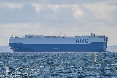
ARC DEFENDER
Ro-Ro/Passenger Ship

Current Trip
USBAL>ANTWERP BE.
| Time Travelled | 10 days |
|---|---|
| Remaining Time | --- |
| Distance Travelled | 3736.32 nm |
| Remaining Distance | --- |
| AVG Speed | 14 Knopen |
| MAX Speed | 17.3 Knopen |
| AVG Wind | 16.5 knots |
| MAX Wind | 34 knots |
| MIN Temp | -4.1°C / 24.62°F |
| MAX Temp | 13.4°C / 56.12°F |
| Diepgang | 9.5 M |
| Positie ontvangen | 1 m geleden |
Current Position
| Lengtegraad | --- |
|---|---|
| Breedtegraat | --- |
| Status | Under way using engine |
| Snelheid | 9.3 Knopen |
| Koers | 84.6° |
| Gebied | North Sea |
| Station | T-AIS |
| Positie ontvangen | 1 m geleden |
Information
The current position of ARC DEFENDER is in North Sea with coordinates 51.42033° / 3.54886° as reported on 2025-03-03 15:24 by AIS to our vessel tracker app. The vessel's current speed is 9.3 Knopen
The vessel ARC DEFENDER (IMO: 9375264, MMSI: 338145000) is a Ro-Ro/Passenger Ship that was built in 2008 ( 17 Jaar oud ). It's sailing under the flag of [US] USA.
In this page you can find informations about the vessels current position, last detected port calls, and current voyage information. If the vessels is not in coverage by AIS you will find the latest position.
The current position of ARC DEFENDER is detected by our AIS receivers and we are not responsible for the reliability of the data. The last position was recorded while the vessel was in Coverage by the Ais receivers of our vessel tracking app.
The current draught of ARC DEFENDER as reported by AIS is 9.5 meters
Weather
| Temperature | 6°C / 42.8°F |
|---|---|
| Wind Speed | 6 knots |
| Direction | 16° NNE |
| Pressure | 1029.1 hPa |
| Humidity | 73.7 % |
| Cloud Coverage | 2 % |


Featured Company
Last Port Calls
| Port | Arrival | Departure | Time In Port |
|---|---|---|---|
| 2025-02-18 11:22 | 2025-02-20 22:00 | 2 d | |
| 2025-02-15 09:55 | 2025-02-16 12:51 | 1 d | |
| 2025-02-14 10:37 | 2025-02-14 20:37 | 9 h | |
| 2025-02-08 15:46 | 2025-02-10 02:30 | 1 d | |
| 2025-02-02 15:44 | 2025-02-07 15:24 | 4 d | |
| 2025-01-28 12:11 | 2025-01-28 21:14 | 9 h | |
| 2025-01-25 12:10 | 2025-01-25 17:15 | 5 h | |
| 2025-01-24 13:14 | 2025-01-25 12:04 | 22 h | |
| 2025-01-11 06:12 | 2025-01-12 10:55 | 1 d | |
| 2025-01-05 11:59 | 2025-01-09 17:54 | 4 d |
Most Visited Ports (Last year)
| Port | Arrivals | |
|---|---|---|
| 11 | ||
| 9 | ||
| 7 | ||
| 6 | ||
| 5 | ||
| 5 |
Last Trips
| Origin | Departure | Destination | Arrival | Distance | |
|---|---|---|---|---|---|
| 2025-02-16 07:51 | 2025-02-18 06:22 | 556.44 nm | |||
| 2025-02-14 15:37 | 2025-02-15 04:55 | 166.57 nm | |||
| 2025-02-09 20:30 | 2025-02-14 05:37 | 1376.43 nm | |||
| 2025-02-07 09:24 | 2025-02-08 09:46 | 243.07 nm | |||
| 2025-01-28 16:14 | 2025-02-02 09:44 | 1459.02 nm | |||
| 2025-01-25 12:15 | 2025-01-28 07:11 | 680.24 nm | |||
| 2025-01-25 07:04 | 2025-01-25 07:10 | 0.69 nm | |||
| 2025-01-12 10:55 | 2025-01-24 08:14 | 4013.73 nm | |||
| 2025-01-09 18:54 | 2025-01-11 06:12 | 466.71 nm | |||
| 2025-01-04 14:34 | 2025-01-05 12:59 | 319.41 nm |
Events
| Tijd | Evenement | Details | Positie / Bestemming | Info |
|---|---|---|---|---|
| 2025-03-03 14:44 | Wijzig zee gebeid | Dutch part of the North Sea Belgian part of the North Sea |
51.40695 / 3.33156
North Sea
USBAL>ANTWERP BE.
|
Snelheid: 12.9 kn Koers: 91° |
| 2025-03-03 11:53 | ETA Changed | 2025/03/03 13:15 2025/03/03 13:00 |
51.33279 / 2.38490
USBAL>ANTWERP BE.
|
Snelheid: 9.5 kn Koers: 60.5° |
| 2025-03-03 11:50 | Wijzig zee gebeid | Belgian part of the North Sea French part of the North Sea |
51.32877 / 2.37308
North Sea
USBAL>ANTWERP BE.
|
Snelheid: 9.7 kn Koers: 60.3° |
| 2025-03-03 08:50 | Wijzig zee gebeid | French part of the North Sea French part of the English Channel |
50.99050 / 1.64405
North Sea
USBAL>ANTWERP BE.
|
Snelheid: 13.5 kn Koers: 32.8° |
| 2025-03-03 05:20 | Wijzig zee gebeid | French part of the English Channel United Kingdom part of the English Channel |
50.46289 / .88394
English Channel
USBAL>ANTWERP BE.
|
Snelheid: 13 kn Koers: 75° |
| 2025-03-02 23:34 | Status Changed | Under way using engine Default |
50.16748 / -1.05044
USBAL>ANTWERP BE.
|
Snelheid: 15.3 kn Koers: 74° |
| 2025-03-02 23:28 | Status Changed | Default Under way using engine |
50.15977 / -1.09384
USBAL>ANTWERP BE.
|
Snelheid: 15.6 kn Koers: 74.6° |
| 2025-03-02 23:19 | Wijzig zee gebeid | United Kingdom part of the English Channel French part of the English Channel |
50.14946 / -1.15130
English Channel
USBAL>ANTWERP BE.
|
Snelheid: 15.6 kn Koers: 74.4° |
| 2025-03-02 23:17 | Status Changed | Under way using engine Default |
50.14707 / -1.16450
USBAL>ANTWERP BE.
|
Snelheid: 15.6 kn Koers: 74° |
| 2025-03-02 22:55 | Status Changed | Default Under way using engine |
50.12214 / -1.30427
USBAL>ANTWERP BE.
|
Snelheid: 16.1 kn Koers: 75° |