
ANTARI
Cargo
Current Trip
| Time Travelled | 8 days |
|---|---|
| Remaining Time | --- |
| Distance Travelled | 860.16 nm |
| Remaining Distance | --- |
| AVG Speed | 7.5 Knopen |
| MAX Speed | 11.8 Knopen |
| AVG Wind | 13.5 knots |
| MAX Wind | 25 knots |
| MIN Temp | 7.9°C / 46.22°F |
| MAX Temp | 16.5°C / 61.7°F |
| Diepgang | 5 M |
| Positie ontvangen | 9 m geleden |
Current Position
| Lengtegraad | --- |
|---|---|
| Breedtegraat | --- |
| Status | At anchor |
| Snelheid | |
| Koers | 266° |
| Gebied | Mediterranean Sea - Western Basin |
| Station | T-AIS |
| Positie ontvangen | 9 m geleden |
Info
Information
The current position of ANTARI is in Mediterranean Sea - Western Basin with coordinates 37.55649° / -1.11169° as reported on 2026-01-09 11:13 by AIS to our vessel tracker app. The vessel's current speed is 0 Knopen and is heading at the port of SKIKDA. The estimated time of arrival as calculated by MyShipTracking vessel tracking app is 2026-01-08 13:00 LT
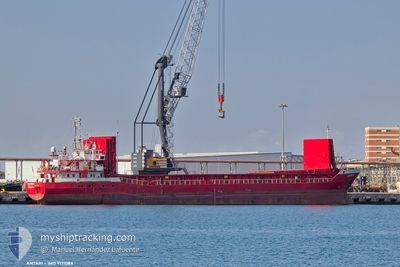
The vessel ANTARI (MMSI: 314652000) is a Cargo It's sailing under the flag of [BB] Barbados.
In this page you can find informations about the vessels current position, last detected port calls, and current voyage information. If the vessels is not in coverage by AIS you will find the latest position.
The current position of ANTARI is detected by our AIS receivers and we are not responsible for the reliability of the data. The last position was recorded while the vessel was in Coverage by the Ais receivers of our vessel tracking app.
The current draught of ANTARI as reported by AIS is 5 meters
Weather
| Temperature | 14.6°C / 58.28°F |
|---|---|
| Wind Speed | 6 knots |
| Direction | 273° W |
| Pressure | 1024.7 hPa |
| Humidity | 56.4 % |
| Cloud Coverage | 81 % |
Featured Company
Last Port Calls
| Port | Arrival | Departure | Time In Port |
|---|---|---|---|
| 2025-12-29 20:55 | 2025-12-31 13:47 | 1 d | |
| 2025-12-25 07:32 | 2025-12-27 08:12 | 2 d | |
| 2025-11-29 21:18 | 2025-12-03 15:17 | 3 d | |
| 2025-11-26 04:34 | 2025-11-27 15:54 | 1 d | |
| 2025-11-18 19:04 | |||
| 2025-11-04 14:12 | 2025-11-05 19:28 | 1 d |
Last Trips
| Origin | Departure | Destination | Arrival | Distance | |
|---|---|---|---|---|---|
| 2025-12-27 08:12 | 2025-12-29 20:55 | 111.48 nm | |||
| 2025-12-03 15:17 | 2025-12-25 07:32 | 2763.90 nm | |||
| 2025-11-27 15:54 | 2025-11-29 21:18 | 488.40 nm | |||
| 2025-11-18 19:04 | 2025-11-26 04:34 | 1253.57 nm | |||
| 2025-10-25 19:20 | 2025-11-04 14:12 | 1724.80 nm |
Events
| Tijd | Evenement | Details | Positie / Bestemming | Info |
|---|---|---|---|---|
| 2026-01-09 11:16 | Status Changed | Default At anchor |
37.55649 / -1.11172
DZ SKI
|
Snelheid: Koers: 266° |
| 2026-01-09 11:13 | Status Changed | At anchor Default |
37.55649 / -1.11169
DZ SKI
|
Snelheid: 0.2 kn Koers: 277° |
| 2026-01-09 10:37 | Status Changed | Default At anchor |
37.55626 / -1.11176
DZ SKI
|
Snelheid: Koers: 263° |
| 2026-01-09 10:31 | Status Changed | At anchor Default |
37.55647 / -1.11170
DZ SKI
|
Snelheid: Koers: 250° |
| 2026-01-09 10:13 | Status Changed | Default At anchor |
37.55682 / -1.11180
DZ SKI
|
Snelheid: Koers: 238° |
| 2026-01-09 10:05 | Status Changed | At anchor Default |
37.55712 / -1.11194
DZ SKI
|
Snelheid: Koers: 219° |
| 2026-01-09 09:49 | Status Changed | Default At anchor |
37.55722 / -1.11207
DZ SKI
|
Snelheid: Koers: 236° |
| 2026-01-09 09:46 | Status Changed | At anchor Default |
37.55712 / -1.11193
DZ SKI
|
Snelheid: 0.3 kn Koers: 248° |
| 2026-01-09 09:31 | Binnenbereik |
37.55712 / -1.11193
Mediterranean Sea - Western Basin
|
Snelheid: Koers: 296° |
|
| 2026-01-09 06:37 | Buitenbereik |
37.55569 / -1.11284
Mediterranean Sea - Western Basin
|
Snelheid: Koers: 70° |