
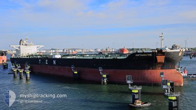
ANTARCTIC
Crude Oil Tanker
Current Trip
| Time Travelled | 8 days |
|---|---|
| Remaining Time | 1 day |
| Distance Travelled | 1536.04 nm |
| Remaining Distance | 1557.71 nm |
| AVG Speed | 12.4 Knopen |
| MAX Speed | 13.8 Knopen |
| AVG Wind | 14.5 knots |
| MAX Wind | 22.8 knots |
| MIN Temp | 18.9°C / 66.02°F |
| MAX Temp | 25.6°C / 78.08°F |
| Diepgang | 9.5 M |
| Positie ontvangen | 5 d geleden |
Current Position
| Lengtegraad | -79.42593° |
|---|---|
| Breedtegraat | 26.29293° |
| Status | Under way using engine |
| Snelheid | 13.1 Knopen |
| Koers | 1° |
| Gebied | North Atlantic Ocean |
| Station | T-AIS |
| Positie ontvangen | 5 d geleden |
Info
Information
The current position of ANTARCTIC is in North Atlantic Ocean with coordinates 26.29293° / -79.42593° as reported on 2024-04-27 05:19 by AIS to our vessel tracker app. The vessel's current speed is 13.1 Knopen and is heading at the port of CORPUS CHRISTI. The estimated time of arrival as calculated by MyShipTracking vessel tracking app is 2024-05-03 21:44 LT
The vessel ANTARCTIC (IMO: 9315185, MMSI: 636015560) is a Crude Oil Tanker that was built in 2007 ( 17 Jaar oud ). It's sailing under the flag of [LR] Liberia.
In this page you can find informations about the vessels current position, last detected port calls, and current voyage information. If the vessels is not in coverage by AIS you will find the latest position.
The current position of ANTARCTIC is detected by our AIS receivers and we are not responsible for the reliability of the data. The last position was recorded while the vessel was in Coverage by the Ais receivers of our vessel tracking app.
The current draught of ANTARCTIC as reported by AIS is 9.5 meters
Weather
| Temperature | 18.9°C / 66.02°F |
|---|---|
| Wind Speed | 15 knots |
| Direction | 68° ENE |
| Pressure | 1025.6 hPa |
| Humidity | 62 % |
| Cloud Coverage | 98 % |
Featured Company
Last Port Calls
| Port | Arrival | Departure | Time In Port |
|---|---|---|---|
| 2024-04-21 16:26 | 2024-04-23 13:02 | 1 d | |
| 2024-04-08 17:12 | 2024-04-11 00:20 | 2 d | |
| 2024-03-25 15:43 | 2024-03-27 02:19 | 1 d | |
| 2024-03-10 10:59 | 2024-03-12 08:48 | 1 d |
Most Visited Ports (Last year)
| Port | Arrivals | |
|---|---|---|
| 3 | ||
| 2 | ||
| 2 | ||
| 2 | ||
| 2 | ||
| 1 |
Last Trips
| Origin | Departure | Destination | Arrival | Distance | |
|---|---|---|---|---|---|
| 2024-04-10 19:20 | 2024-04-21 11:26 | 220.14 nm | |||
| 2024-03-26 23:49 | 2024-04-08 12:12 | 3010.48 nm | |||
| 2024-03-12 08:48 | 2024-03-25 13:13 | 2518.43 nm | |||
| 2024-02-27 20:57 | 2024-03-10 10:59 | 2300.01 nm |
Events
| Tijd | Evenement | Details | Positie / Bestemming | Info |
|---|---|---|---|---|
| 2024-04-27 05:28 | Status Changed | Default Under way using engine |
26.32547 / -79.42530
USHOU>>>USCRP
|
Snelheid: 13.1 kn Koers: 1° |
| 2024-04-27 05:19 | Buitenbereik |
26.29293 / -79.42593
North Atlantic Ocean
|
Snelheid: 13.1 kn Koers: 1° |
|
| 2024-04-27 04:45 | Status Changed | Under way using engine Default |
26.16995 / -79.42573
USHOU>>>USCRP
|
Snelheid: 13.1 kn Koers: 355° |
| 2024-04-27 04:41 | Status Changed | Default Under way using engine |
26.15233 / -79.42450
USHOU>>>USCRP
|
Snelheid: 13 kn Koers: 354° |
| 2024-04-27 04:17 | Status Changed | Under way using engine Default |
26.06840 / -79.41623
USHOU>>>USCRP
|
Snelheid: 13.1 kn Koers: 9° |
| 2024-04-27 03:35 | Status Changed | Default Under way using engine |
25.91367 / -79.44173
USHOU>>>USCRP
|
Snelheid: 13.3 kn Koers: 9° |
| 2024-04-27 01:21 | Wijzig zee gebeid | Bahamas part of the North Atlantic Ocean United States part of the Gulf of Mexico |
25.41927 / -79.53295
North Atlantic Ocean
|
Snelheid: 13.3 kn Koers: 9° |
| 2024-04-27 01:21 | Status Changed | Under way using engine Default |
25.41733 / -79.53333
USHOU>>>USCRP
|
Snelheid: 13.2 kn Koers: 9° |
| 2024-04-27 01:05 | Binnenbereik |
25.41927 / -79.53295
North Atlantic Ocean
|
Snelheid: 13.3 kn Koers: 9° |
|
| 2024-04-23 13:02 | Vertrekhaven |
|
27.82200 / -97.17735
USHOU>>>USCRP
|
Snelheid: 6.5 kn Koers: 80° |