
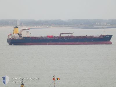
ALLEGRA
Oil/Chemical Tanker
Current Trip
| Trip Time | 19 days |
|---|---|
| Trip Distance | 1162.62 nm |
| AVG Speed | 11.3 Knopen |
| MAX Speed | 14.6 Knopen |
| Diepgang | 9.4 M |
| AVG Wind | 14.1 knots |
| MAX Wind | 27 knots |
| MIN Temp | 11.4°C / 52.52°F |
| MAX Temp | 18.3°C / 64.94°F |
| Positie ontvangen | 5 d geleden |
Current Position
| Lengtegraad | --- |
|---|---|
| Breedtegraat | --- |
| Status | Under way using engine |
| Snelheid | 3.5 Knopen |
| Koers | 113° |
| Gebied | Mediterranean Sea - Eastern Basin |
| Station | T-AIS |
| Positie ontvangen | 5 d geleden |
Info
Information
The current position of ALLEGRA is in Mediterranean Sea - Eastern Basin with coordinates 32.40267° / 15.30527° as reported on 2025-03-01 17:24 by AIS to our vessel tracker app. The vessel's current speed is 3.5 Knopen and is currently inside the port of MISURATA.
The vessel ALLEGRA (IMO: 9436707, MMSI: 247276100) is a Oil/Chemical Tanker that was built in 2009 ( 16 Jaar oud ). It's sailing under the flag of [IT] Italy.
In this page you can find informations about the vessels current position, last detected port calls, and current voyage information. If the vessels is not in coverage by AIS you will find the latest position.
The current position of ALLEGRA is detected by our AIS receivers and we are not responsible for the reliability of the data. The last position was recorded while the vessel was in Coverage by the Ais receivers of our vessel tracking app.
The current draught of ALLEGRA as reported by AIS is 9.4 meters
Weather
| Temperature | 15.7°C / 60.26°F |
|---|---|
| Wind Speed | 15 knots |
| Direction | 139° SE |
| Pressure | 1018.7 hPa |
| Humidity | 64.3 % |
| Cloud Coverage | 100 % |
Featured Company
Last Port Calls
| Port | Arrival | Departure | Time In Port |
|---|---|---|---|
| 2025-03-04 23:31 | |||
| 2025-02-08 16:42 | 2025-02-13 08:43 | 4 d | |
| 2025-01-31 16:00 | 2025-02-01 11:51 | 19 h | |
| 2025-01-27 06:33 | 2025-01-30 08:24 | 3 d | |
| 2025-01-22 11:55 | 2025-01-24 06:09 | 1 d | |
| 2025-01-11 15:14 | 2025-01-12 15:33 | 1 d | |
| 2025-01-01 15:53 |
Last Trips
| Origin | Departure | Destination | Arrival | Distance | |
|---|---|---|---|---|---|
| 2025-02-13 10:43 | 2025-03-05 01:31 | 1162.62 nm | |||
| 2025-02-01 13:51 | 2025-02-08 18:42 | 1429.83 nm | |||
| 2025-01-30 09:24 | 2025-01-31 18:00 | 381.11 nm | |||
| 2025-01-24 07:09 | 2025-01-27 07:33 | 749.09 nm | |||
| 2025-01-12 16:33 | 2025-01-22 12:55 | 839.98 nm | |||
| 2025-01-01 16:53 | 2025-01-11 16:14 | 1428.54 nm |
Events
| Tijd | Evenement | Details | Positie / Bestemming | Info |
|---|---|---|---|---|
| 2025-03-05 00:01 | Stop beweging |
32.36669 / 15.21540
[LY] MISURATA
|
Snelheid: 0.3 kn Koers: 7° |
|
| 2025-03-04 23:31 | Aankomsthaven |
|
32.37160 / 15.23025
[LY] MISURATA
|
Snelheid: 2.1 kn Koers: 74° |
| 2025-03-04 22:07 | Start beweging | 4.4 nm, North East of MISURATA |
32.39719 / 15.31055
MTMLA
|
Snelheid: 4.8 kn Koers: 217° |
| 2025-03-01 17:54 | Stop beweging | 4.39 nm, North East of MISURATA |
32.40268 / 15.30593
MTMLA
|
Snelheid: 0.2 kn Koers: 117° |
| 2025-03-01 17:33 | Status Changed | Default Under way using engine |
32.40240 / 15.30815
MTMLA
|
Snelheid: 3.5 kn Koers: 113° |
| 2025-03-01 17:24 | Buitenbereik |
32.40267 / 15.30527
Mediterranean Sea - Eastern Basin
|
Snelheid: 3.5 kn Koers: 114° |
|
| 2025-03-01 17:20 | Status Changed | Under way using engine Default |
32.40433 / 15.30122
MTMLA
|
Snelheid: 3.9 kn Koers: 128° |
| 2025-03-01 16:29 | Status Changed | Default Under way using engine |
32.52692 / 15.25529
MTMLA
|
Snelheid: 11.4 kn Koers: 170.3° |
| 2025-03-01 16:23 | Status Changed | Under way using engine Default |
32.54774 / 15.25191
MTMLA
|
Snelheid: 11.4 kn Koers: 171° |
| 2025-03-01 16:22 | Status Changed | Default Under way using engine |
32.55136 / 15.25117
MTMLA
|
Snelheid: 11.4 kn Koers: 170.6° |