
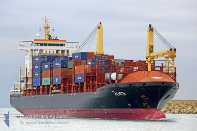
ALIOTH
Container Ship
Current Trip
COBUN
| Time Travelled | 2 days |
|---|---|
| Remaining Time | --- |
| Distance Travelled | 5.30 nm |
| Remaining Distance | --- |
| AVG Speed | 3.3 Knopen |
| MAX Speed | 3.3 Knopen |
| AVG Wind | 4.5 knots |
| MAX Wind | 10.2 knots |
| MIN Temp | 15.1°C / 59.18°F |
| MAX Temp | 24.1°C / 75.38°F |
| Diepgang | 8.1 M |
| Positie ontvangen | 2024-11-10 18:46 |
Current Position
| Lengtegraad | --- |
|---|---|
| Breedtegraat | --- |
| Status | Under way using engine |
| Snelheid | |
| Koers | 226° |
| Gebied | North Pacific Ocean |
| Station | T-AIS |
| Positie ontvangen | 2024-11-10 18:46 |
Info
Information
The current position of ALIOTH is in North Pacific Ocean with coordinates 8.89648° / -79.51065° as reported on 2024-11-10 18:46 by AIS to our vessel tracker app. The vessel's current speed is 0 Knopen
The vessel ALIOTH (IMO: 9339600, MMSI: 636021166) is a Container Ship that was built in 2006 ( 18 Jaar oud ). It's sailing under the flag of [LR] Liberia.
In this page you can find informations about the vessels current position, last detected port calls, and current voyage information. If the vessels is not in coverage by AIS you will find the latest position.
The current position of ALIOTH is detected by our AIS receivers and we are not responsible for the reliability of the data. The last position was recorded while the vessel was in Coverage by the Ais receivers of our vessel tracking app.
The current draught of ALIOTH as reported by AIS is 8.1 meters
Weather
| Temperature | 20.5°C / 68.9°F |
|---|---|
| Wind Speed | 8 knots |
| Direction | 252° WSW |
| Pressure | 1011.4 hPa |
| Humidity | 63.9 % |
| Cloud Coverage | 89 % |
Featured Company
Last Port Calls
| Port | Arrival | Departure | Time In Port |
|---|---|---|---|
| 2024-12-28 10:49 | 2024-12-28 12:48 | 1 h | |
| 2024-12-27 00:38 | 2024-12-28 02:38 | 1 d | |
| 2024-12-24 04:51 | 2024-12-24 19:01 | 14 h | |
| 2024-12-19 15:14 | 2024-12-20 12:22 | 21 h | |
| 2024-12-13 14:33 | 2024-12-14 08:38 | 18 h | |
| 2024-12-09 09:56 | 2024-12-10 05:37 | 19 h | |
| 2024-12-08 00:57 | 2024-12-08 23:34 | 22 h | |
| 2024-12-04 23:13 | 2024-12-06 02:13 | 1 d | |
| 2024-11-29 08:32 | 2024-12-01 03:45 | 1 d | |
| 2024-11-28 00:32 | 2024-11-29 00:49 | 1 d |
Most Visited Ports (Last year)
| Port | Arrivals | |
|---|---|---|
| 22 | ||
| 13 | ||
| 11 | ||
| 9 | ||
| 8 | ||
| 6 |
Last Trips
| Origin | Departure | Destination | Arrival | Distance | |
|---|---|---|---|---|---|
| 2024-12-27 23:38 | 2024-12-28 05:49 | 93.07 nm | |||
| 2024-12-24 16:01 | 2024-12-26 21:38 | 132.99 nm | |||
| 2024-12-20 07:22 | 2024-12-24 01:51 | 659.09 nm | |||
| 2024-12-14 03:38 | 2024-12-19 10:14 | 88.20 nm | |||
| 2024-12-10 02:37 | 2024-12-13 09:33 | 656.15 nm | |||
| 2024-12-08 20:34 | 2024-12-09 06:56 | 114.39 nm | |||
| 2024-12-05 21:13 | 2024-12-07 21:57 | 658.98 nm | |||
| 2024-11-30 22:45 | 2024-12-04 18:13 | 515.78 nm | |||
| 2024-11-28 21:49 | 2024-11-29 03:32 | 93.15 nm | |||
| 2024-11-27 08:04 | 2024-11-27 21:32 | 123.10 nm |
Events
| Tijd | Evenement | Details | Positie / Bestemming | Info |
|---|---|---|---|---|
| 2024-12-28 13:50 | Stop beweging | 2.27 nm, North of ILO |
-17.61457 / -71.36790
COBUN
|
Snelheid: 0.2 kn Koers: 174° |
| 2024-12-28 12:57 | Start beweging | 0.57 nm, North West of ILO |
-17.64626 / -71.36420
COBUN
|
Snelheid: 3.2 kn Koers: 236° |
| 2024-12-28 12:48 | Vertrekhaven |
|
-17.64513 / -71.35901
COBUN
|
Snelheid: 0.2 kn Koers: 259° |
| 2024-12-28 10:49 | Aankomsthaven |
|
-17.64445 / -71.35248
[PE] ILO
|
Snelheid: 2.6 kn Koers: 241° |
| 2024-12-28 10:20 | Stop beweging | 0.99 nm, North West of ILO |
-17.64135 / -71.36968
COBUN
|
Snelheid: 0.3 kn Koers: 129° |
| 2024-12-28 02:42 | Start beweging | 0.39 nm, North West of ARICA |
-18.46621 / -70.33084
COBUN
|
Snelheid: 4.9 kn Koers: 296° |
| 2024-12-28 02:38 | Vertrekhaven |
|
-18.46544 / -70.32601
COBUN
|
Snelheid: 3 kn Koers: 198° |
| 2024-12-27 00:38 | Stop beweging |
-18.47152 / -70.32724
[CL] ARICA
|
Snelheid: 0.1 kn Koers: 199° |
|
| 2024-12-27 00:38 | Aankomsthaven |
|
-18.47152 / -70.32724
[CL] ARICA
|
Snelheid: 1.5 kn Koers: 209° |
| 2024-12-26 22:42 | Start beweging | 8.99 nm, West of ARICA |
-18.41861 / -70.47352
COBUN
|
Snelheid: 3.1 kn Koers: 268° |