
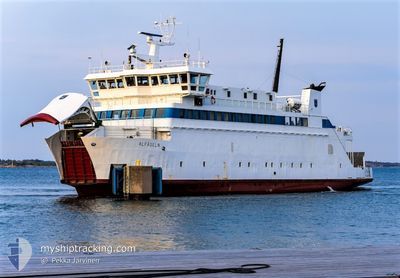
ALFAGELN
Passenger
Current Trip
HUMMELVIK/TORSHOLMA
| Time Travelled | 44 days |
|---|---|
| Remaining Time | --- |
| Distance Travelled | 2387.74 nm |
| Remaining Distance | --- |
| AVG Speed | 11.6 Knopen |
| MAX Speed | 14.9 Knopen |
| AVG Wind | 17 knots |
| MAX Wind | 39 knots |
| MIN Temp | -6.1°C / 21.02°F |
| MAX Temp | 8.1°C / 46.58°F |
| Diepgang | 3.8 M |
| Positie ontvangen | 13 h, 52 m geleden |
Current Position
| Lengtegraad | --- |
|---|---|
| Breedtegraat | --- |
| Status | Under way using engine |
| Snelheid | 9.1 Knopen |
| Koers | 185.3° |
| Gebied | Gulf of Bothnia |
| Station | T-AIS |
| Positie ontvangen | 13 h, 52 m geleden |
Info
Information
The current position of ALFAGELN is in Gulf of Bothnia with coordinates 60.35244° / 21.03779° as reported on 2026-01-10 06:03 by AIS to our vessel tracker app. The vessel's current speed is 9.1 Knopen
The vessel ALFAGELN (IMO: 891570, MMSI: 230992670) is a Passenger It's sailing under the flag of [FI] Finland.
In this page you can find informations about the vessels current position, last detected port calls, and current voyage information. If the vessels is not in coverage by AIS you will find the latest position.
The current position of ALFAGELN is detected by our AIS receivers and we are not responsible for the reliability of the data. The last position was recorded while the vessel was in Coverage by the Ais receivers of our vessel tracking app.
The current draught of ALFAGELN as reported by AIS is 3.8 meters
Weather
| Temperature | -3.1°C / 26.42°F |
|---|---|
| Wind Speed | 28 knots |
| Direction | 26° NNE |
| Pressure | 1014.8 hPa |
| Humidity | 71.3 % |
| Cloud Coverage | 100 % |
Featured Company
Events
| Tijd | Evenement | Details | Positie / Bestemming | Info |
|---|---|---|---|---|
| 2026-01-10 11:33 | Start beweging | 7.26 nm, North of OVERO |
60.22481 / 20.42617
HUMMELVIK/TORSHOLMA
|
Snelheid: 3.5 kn Koers: 50° |
| 2026-01-10 09:18 | Stop beweging | 7.25 nm, North East of LANGNAS |
60.22407 / 20.41427
HUMMELVIK/TORSHOLMA
|
Snelheid: Koers: 116° |
| 2026-01-10 06:16 | Status Changed | Default Under way using engine |
60.31917 / 21.00880
HUMMELVIK/TORSHOLMA
|
Snelheid: 9.1 kn Koers: 185.3° |
| 2026-01-10 06:03 | Status Changed | Under way using engine Default |
60.35244 / 21.03779
HUMMELVIK/TORSHOLMA
|
Snelheid: 9.4 kn Koers: 26° |
| 2026-01-10 06:03 | Buitenbereik |
60.35244 / 21.03779
Gulf of Bothnia
|
Snelheid: 9.1 kn Koers: 185.3° |
|
| 2026-01-10 05:40 | Status Changed | Default Under way using engine |
60.33859 / 21.03231
HUMMELVIK/TORSHOLMA
|
Snelheid: 9.9 kn Koers: 63.4° |
| 2026-01-10 05:05 | Status Changed | Under way using engine Default |
60.29084 / 20.96783
HUMMELVIK/TORSHOLMA
|
Snelheid: 11.2 kn Koers: 89° |
| 2026-01-10 04:36 | Status Changed | Default Under way using engine |
60.29583 / 20.79532
HUMMELVIK/TORSHOLMA
|
Snelheid: 6.6 kn Koers: 187.6° |
| 2026-01-10 04:23 | Status Changed | Under way using engine Default |
60.29373 / 20.79231
HUMMELVIK/TORSHOLMA
|
Snelheid: 10.1 kn Koers: 135° |
| 2026-01-10 03:32 | Status Changed | Default Under way using engine |
60.26230 / 20.61284
HUMMELVIK/TORSHOLMA
|
Snelheid: 12.8 kn Koers: 78.9° |