

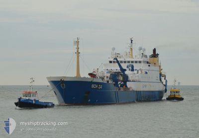
AFRIKA
Factory Trawler

Current Trip
| Time Travelled | 14 days |
|---|---|
| Remaining Time | 1 day |
| Distance Travelled | 1245.38 nm |
| Remaining Distance | 396.55 nm |
| AVG Speed | 13.4 Knopen |
| MAX Speed | 17.9 Knopen |
| AVG Wind | 12.3 knots |
| MAX Wind | 21.8 knots |
| MIN Temp | 6.6°C / 43.88°F |
| MAX Temp | 14°C / 57.2°F |
| Diepgang | 7.2 M |
| Positie ontvangen | Nu |
Current Position
| Lengtegraad | --- |
|---|---|
| Breedtegraat | --- |
| Status | Under way using engine |
| Snelheid | 14.6 Knopen |
| Koers | 84.9° |
| Gebied | English Channel |
| Station | T-AIS |
| Positie ontvangen | Nu |
Information
The current position of AFRIKA is in English Channel with coordinates 49.76899° / -4.19370° as reported on 2025-03-25 11:36 by AIS to our vessel tracker app. The vessel's current speed is 14.6 Knopen and is heading at the port of IJMUIDEN. The estimated time of arrival as calculated by MyShipTracking vessel tracking app is 2025-03-26 15:47 LT
The vessel AFRIKA (IMO: 9175834, MMSI: 245811000) is a Factory Trawler that was built in 1999 ( 26 Jaar oud ). It's sailing under the flag of [NL] Netherlands.
In this page you can find informations about the vessels current position, last detected port calls, and current voyage information. If the vessels is not in coverage by AIS you will find the latest position.
The current position of AFRIKA is detected by our AIS receivers and we are not responsible for the reliability of the data. The last position was recorded while the vessel was in Coverage by the Ais receivers of our vessel tracking app.
The current draught of AFRIKA as reported by AIS is 7.2 meters
Weather
| Temperature | 10.1°C / 50.18°F |
|---|---|
| Wind Speed | 8 knots |
| Direction | 298° WNW |
| Pressure | 1024.8 hPa |
| Humidity | 76 % |
| Cloud Coverage | 100 % |


Featured Company
Last Port Calls
| Port | Arrival | Departure | Time In Port |
|---|---|---|---|
| 2025-03-04 19:28 | 2025-03-10 14:14 | 5 d | |
| 2025-02-01 16:05 | 2025-02-07 15:47 | 5 d | |
| 2025-01-06 11:18 |
Most Visited Ports (Last year)
| Port | Arrivals | |
|---|---|---|
| 7 | ||
| 4 |
Last Trips
| Origin | Departure | Destination | Arrival | Distance | |
|---|---|---|---|---|---|
| 2025-02-07 15:47 | 2025-03-04 19:28 | 1369.70 nm | |||
| 2025-01-06 11:18 | 2025-02-01 16:05 | 2022.86 nm |
Events
| Tijd | Evenement | Details | Positie / Bestemming | Info |
|---|---|---|---|---|
| 2025-03-25 08:20 | Wijzig zee gebeid | United Kingdom part of the English Channel United Kingdom part of the Celtic Sea |
49.68585 / -5.40511
English Channel
|
Snelheid: 14 kn Koers: 84.5° |
| 2025-03-25 05:23 | Destination Changed | IJMUIDEN FISHING GROUNDS |
49.64861 / -6.47344
IJMUIDEN
|
Snelheid: 14.3 kn Koers: 93.8° |
| 2025-03-24 23:56 | Wijzig zee gebeid | United Kingdom part of the Celtic Sea Irish part of the Celtic Sea |
50.41577 / -8.11952
Celtic Sea
|
Snelheid: 14.4 kn Koers: 127.4° |
| 2025-03-24 17:54 | Wijzig zee gebeid | Irish part of the Celtic Sea Irish part of the North Atlantic Ocean |
51.28224 / -9.94875
Celtic Sea
|
Snelheid: 13.7 kn Koers: 126.5° |
| 2025-03-24 15:20 | Binnenbereik |
51.65805 / -10.63491
North Atlantic Ocean
|
Snelheid: 12.3 kn Koers: 146° |
|
| 2025-03-24 05:12 | Buitenbereik |
53.61038 / -12.03540
North Atlantic Ocean
|
Snelheid: 12.9 kn Koers: 162.7° |
|
| 2025-03-24 04:42 | Binnenbereik |
53.71231 / -12.09296
North Atlantic Ocean
|
Snelheid: 12.7 kn Koers: 161.3° |
|
| 2025-03-23 21:05 | Buitenbereik |
54.02093 / -12.45154
North Atlantic Ocean
|
Snelheid: 3.5 kn Koers: 190.3° |
|
| 2025-03-23 21:05 | Binnenbereik |
54.02093 / -12.45154
North Atlantic Ocean
|
Snelheid: 3.5 kn Koers: 190.3° |
|
| 2025-03-23 18:39 | Buitenbereik |
54.07036 / -12.43981
North Atlantic Ocean
|
Snelheid: 6.5 kn Koers: 342.8° |