

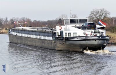
ZWARTEWATER
Cargo

Current Trip
ZWARTEWATER is out of coverage. Learn how you can join the community and extend the coverage to your area by clicking here!
MEPPEL
Unknown Port
ETA*
2025-12-28 09:53 UTC
| Time Travelled | 2 days |
|---|---|
| Remaining Time | --- |
| Distance Travelled | 77.97 nm |
| Remaining Distance | --- |
| AVG Speed | 6.6 Noeuds |
| MAX Speed | 9 Noeuds |
| AVG Wind | 5.9 knots |
| MAX Wind | 9 knots |
| MIN Temp | -1.1°C / 30.02°F |
| MAX Temp | 5.3°C / 41.54°F |
| Tirant d eau | 0 m |
| Position reçue | 1 d depuis |
Current Position
| Longitude | --- |
|---|---|
| Latitude | --- |
| Etat | Under way using engine |
| Vitesse | 8.1 Noeuds |
| Parcours | 36.1° |
| Zone | North Sea |
| Station | T-AIS |
| Position reçue | 1 d depuis |
Information
The current position of ZWARTEWATER is in North Sea with coordinates 52.06120° / 6.13956° as reported on 2025-02-13 11:57 by AIS to our vessel tracker app. The vessel's current speed is 8.1 Noeuds
The vessel ZWARTEWATER (MMSI: 244670346) is a Cargo It's sailing under the flag of [NL] Netherlands.
In this page you can find informations about the vessels current position, last detected port calls, and current voyage information. If the vessels is not in coverage by AIS you will find the latest position.
The current position of ZWARTEWATER is detected by our AIS receivers and we are not responsible for the reliability of the data. The last position was recorded while the vessel was in Coverage by the Ais receivers of our vessel tracking app.
Weather
| Temperature | 0.3°C / 32.54°F |
|---|---|
| Wind Speed | 9 knots |
| Direction | 13° NNE |
| Pressure | 1021.9 hPa |
| Humidity | 71.4 % |
| Cloud Coverage | 67 % |


Featured Company
Limited time offer - Install a base station receiver to your area and list your company on MyShipTracking Free forever!
Last Port Calls
| Port | Arrival | Departure | Time In Port |
|---|---|---|---|
| 2025-02-12 13:23 | 2025-02-12 13:30 | 7 m | |
| 2025-02-12 07:30 | 2025-02-12 12:28 | 4 h | |
| 2025-02-11 20:04 | 2025-02-12 06:34 | 10 h | |
| 2025-02-11 16:51 | 2025-02-11 17:11 | 19 m | |
| 2025-02-11 13:56 | 2025-02-11 14:02 | 6 m | |
| 2025-02-06 15:42 | 2025-02-11 11:21 | 4 d | |
| 2025-02-03 15:22 | 2025-02-03 16:08 | 45 m | |
| 2025-01-29 18:49 | 2025-01-30 02:58 | 8 h | |
| 2025-01-29 09:17 | 2025-01-29 17:48 | 8 h | |
| 2025-01-28 17:06 | 2025-01-29 08:08 | 15 h |
Most Visited Ports (Last year)
| Port | Arrivals | |
|---|---|---|
| 35 | ||
| 18 | ||
| 11 | ||
| 10 | ||
| 9 | ||
| 8 |
Last Trips
| Origin | Departure | Destination | Arrival | Distance | |
|---|---|---|---|---|---|
| 2025-02-12 13:28 | 2025-02-12 14:23 | 7.02 nm | |||
| 2025-02-12 07:34 | 2025-02-12 08:30 | 7.33 nm | |||
| 2025-02-11 18:11 | 2025-02-11 21:04 | 28.79 nm | |||
| 2025-02-11 15:02 | 2025-02-11 17:51 | 23.68 nm | |||
| 2025-02-11 12:21 | 2025-02-11 14:56 | 20.69 nm | |||
| 2025-02-03 17:08 | 2025-02-06 16:42 | 18.85 nm | |||
| 2025-01-30 03:58 | 2025-02-03 16:22 | 116.27 nm | |||
| 2025-01-29 18:48 | 2025-01-29 19:49 | 4.95 nm | |||
| 2025-01-29 09:08 | 2025-01-29 10:17 | 7.69 nm | |||
| 2025-01-28 14:38 | 2025-01-28 18:06 | 28.76 nm |
Events
| Heure | Evenement | Détails | Position/ Destination | Info |
|---|---|---|---|---|
| 2025-02-13 11:57 | Hors de la zone couverte |
52.06120 / 6.13956
North Sea
|
Vitesse: 8.1 kn Parcours: 36.1° |
|
| 2025-02-13 08:39 | Démarrage | 0.41 nm, North West of DRIEL |
51.96822 / 5.80859
MEPPEL
|
Vitesse: 4.9 kn Parcours: 59.2° |
| 2025-02-13 08:26 | Arret | 0.46 nm, North West of DRIEL |
51.96718 / 5.80572
MEPPEL
|
Vitesse: 0.1 kn Parcours: 511° |
| 2025-02-13 05:32 | Démarrage | 0.66 nm, North East of MAURIK |
51.97941 / 5.42037
MEPPEL
|
Vitesse: 3.1 kn Parcours: 52.9° |
| 2025-02-12 19:24 | Arret | 0.46 nm, North West of MAURIK |
51.97619 / 5.40761
MEPPEL
|
Vitesse: 0.1 kn Parcours: 511° |
| 2025-02-12 17:17 | Démarrage | 1.44 nm, East of VIANEN |
51.99086 / 5.13638
MEPPEL
|
Vitesse: 3.7 kn Parcours: 146.3° |
| 2025-02-12 17:03 | Arret | 1.38 nm, East of VIANEN |
51.99231 / 5.13465
MEPPEL
|
Vitesse: 0.1 kn Parcours: 511° |
| 2025-02-12 13:30 | PORT DE DEPART |
|
51.91467 / 4.51053
MEPPEL
|
Vitesse: 8.1 kn Parcours: 129.7° |
| 2025-02-12 13:23 | Port d'arrivée |
|
51.91226 / 4.48946
[NL] ROTTERDAM CENTRUM
|
Vitesse: 7.8 kn Parcours: 40.8° |
| 2025-02-12 12:28 | PORT DE DEPART |
|
51.89319 / 4.31718
MEPPEL
|
Vitesse: 6.3 kn Parcours: 85.5° |