
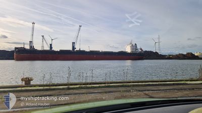
ZHENG RONG
Cargo
Current Trip
| Trip Time | 30 days |
|---|---|
| Trip Distance | 5476.18 nm |
| AVG Speed | 9.1 Noeuds |
| MAX Speed | 9.1 Noeuds |
| Tirant d eau | 14.4 m |
| AVG Wind | 18.1 knots |
| MAX Wind | 52 knots |
| MIN Temp | -1.1°C / 30.02°F |
| MAX Temp | 16.2°C / 61.16°F |
| Position reçue | 6 d depuis |
Current Position
| Longitude | --- |
|---|---|
| Latitude | --- |
| Etat | Under way using engine |
| Vitesse | 10.9 Noeuds |
| Parcours | 48.7° |
| Zone | Mediterranean Sea - Eastern Basin |
| Station | T-AIS |
| Position reçue | 6 d depuis |
Info
Information
The current position of ZHENG RONG is in Mediterranean Sea - Eastern Basin with coordinates 36.49289° / 35.85320° as reported on 2025-02-10 23:18 by AIS to our vessel tracker app. The vessel's current speed is 10.9 Noeuds and is currently inside the port of ISKENDERUN.
The vessel ZHENG RONG (IMO: 9593828, MMSI: 371397000) is a Cargo It's sailing under the flag of [PA] Panama.
In this page you can find informations about the vessels current position, last detected port calls, and current voyage information. If the vessels is not in coverage by AIS you will find the latest position.
The current position of ZHENG RONG is detected by our AIS receivers and we are not responsible for the reliability of the data. The last position was recorded while the vessel was in Coverage by the Ais receivers of our vessel tracking app.
The current draught of ZHENG RONG as reported by AIS is 14.4 meters
Weather
| Temperature | 12.5°C / 54.5°F |
|---|---|
| Wind Speed | 4 knots |
| Direction | 275° W |
| Pressure | 1018.1 hPa |
| Humidity | 54.3 % |
| Cloud Coverage | 1 % |
Featured Company
Last Port Calls
| Port | Arrival | Departure | Time In Port |
|---|---|---|---|
| 2025-02-14 03:37 | |||
| 2025-01-09 02:44 | 2025-01-14 11:37 | 5 d | |
| 2024-12-09 18:31 | 2024-12-23 00:45 | 13 d |
Most Visited Ports (Last year)
| Port | Arrivals | |
|---|---|---|
| 6 | ||
| 3 | ||
| 3 | ||
| 2 | ||
| 1 | ||
| 1 |
Last Trips
| Origin | Departure | Destination | Arrival | Distance | |
|---|---|---|---|---|---|
| 2025-01-14 14:37 | 2025-02-14 06:37 | 5476.18 nm | |||
| 2024-12-23 01:45 | 2025-01-09 05:44 | 3429.43 nm | |||
| 2024-11-27 18:13 | 2024-12-09 19:31 | 2863.86 nm |
Events
| Heure | Evenement | Détails | Position/ Destination | Info |
|---|---|---|---|---|
| 2025-02-14 04:13 | Arret |
36.67658 / 36.19880
[TR] ISKENDERUN
|
Vitesse: Parcours: 67° |
|
| 2025-02-14 03:37 | Port d'arrivée |
|
36.67454 / 36.17543
[TR] ISKENDERUN
|
Vitesse: 5.5 kn Parcours: 132° |
| 2025-02-14 03:25 | Démarrage | 4.56 nm, North of ISKENDERUN |
36.68612 / 36.15990
ISKENDERUN
|
Vitesse: 4.2 kn Parcours: 138° |
| 2025-02-11 01:45 | Arret | 5.07 nm, North of ISKENDERUN |
36.69461 / 36.15906
ISKENDERUN
|
Vitesse: 0.3 kn Parcours: 148° |
| 2025-02-10 23:33 | Etat Changé | Default Under way using engine |
36.52174 / 35.89543
ISKENDERUN
|
Vitesse: 10.9 kn Parcours: 48.7° |
| 2025-02-10 23:18 | Hors de la zone couverte |
36.49289 / 35.85320
Mediterranean Sea - Eastern Basin
ISKENDERUN
|
Vitesse: 10.9 kn Parcours: 48.7° |
|
| 2025-02-10 22:30 | Changement d'ETA | 2025/02/11 01:00 2025/02/12 12:00 |
36.39943 / 35.70682
ISKENDERUN
|
Vitesse: 11.5 kn Parcours: 52.7° |
| 2025-02-10 21:52 | Etat Changé | Under way using engine Default |
36.33714 / 35.57779
ISKENDERUN
|
Vitesse: 11.1 kn Parcours: 66° |
| 2025-02-10 21:33 | Etat Changé | Default Under way using engine |
36.31621 / 35.51181
ISKENDERUN
|
Vitesse: 11 kn Parcours: 65.9° |
| 2025-02-10 21:12 | Changement de zone | Turkish part of the Mediterranean Sea - Eastern Basin Greek part of the Mediterranean Sea - Eastern Basin |
36.28957 / 35.43664
Mediterranean Sea - Eastern Basin
ISKENDERUN
|
Vitesse: 10.6 kn Parcours: 67.4° |