
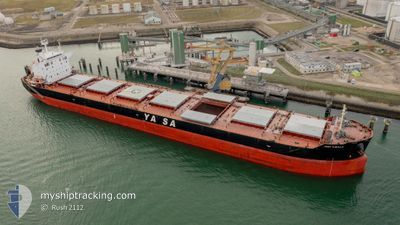
YASA H.MULLA
Bulk Carrier
Current Trip
| Time Travelled | 30 days |
|---|---|
| Remaining Time | --- |
| Distance Travelled | 8828.15 nm |
| Remaining Distance | --- |
| AVG Speed | 12.6 Noeuds |
| MAX Speed | 15.1 Noeuds |
| AVG Wind | 12.1 knots |
| MAX Wind | 27.9 knots |
| MIN Temp | 16.6°C / 61.88°F |
| MAX Temp | 29.9°C / 85.82°F |
| Tirant d eau | 7.2 m |
| Position reçue | 13 d depuis |
Current Position
| Longitude | 18.72621° |
|---|---|
| Latitude | -35.08800° |
| Etat | Under way using engine |
| Vitesse | 12.6 Noeuds |
| Parcours | 301.2° |
| Zone | South Atlantic Ocean |
| Station | T-AIS |
| Position reçue | 13 d depuis |
Info
Information
The current position of YASA H.MULLA is in South Atlantic Ocean with coordinates -35.08800° / 18.72621° as reported on 2024-05-02 20:00 by AIS to our vessel tracker app. The vessel's current speed is 12.6 Noeuds
The vessel YASA H.MULLA (IMO: 9442512, MMSI: 271042868) is a Bulk Carrier that was built in 2011 ( 13 Age ). It's sailing under the flag of [TR] Turkey.
In this page you can find informations about the vessels current position, last detected port calls, and current voyage information. If the vessels is not in coverage by AIS you will find the latest position.
The current position of YASA H.MULLA is detected by our AIS receivers and we are not responsible for the reliability of the data. The last position was recorded while the vessel was in Coverage by the Ais receivers of our vessel tracking app.
The current draught of YASA H.MULLA as reported by AIS is 7.2 meters
Weather
| Temperature | 22.9°C / 73.22°F |
|---|---|
| Wind Speed | 4 knots |
| Direction | 73° ENE |
| Pressure | 1017.2 hPa |
| Humidity | 77.4 % |
| Cloud Coverage | 100 % |
Featured Company
Last Port Calls
| Port | Arrival | Departure | Time In Port |
|---|---|---|---|
| 2024-04-13 09:58 | 2024-04-16 07:55 | 2 d | |
| 2024-04-06 22:11 | 2024-04-08 07:53 | 1 d | |
| 2024-04-01 10:22 | 2024-04-02 17:33 | 1 d | |
| 2024-03-22 04:31 | 2024-03-22 23:11 | 18 h | |
| 2024-03-19 07:22 | 2024-03-21 20:23 | 2 d | |
| 2024-03-13 18:36 |
Most Visited Ports (Last year)
| Port | Arrivals | |
|---|---|---|
| 2 | ||
| 1 | ||
| 1 | ||
| 1 | ||
| 1 | ||
| 1 |
Last Trips
| Origin | Departure | Destination | Arrival | Distance | |
|---|---|---|---|---|---|
| 2024-04-08 13:23 | 2024-04-13 15:28 | 548.83 nm | |||
| 2024-04-02 23:03 | 2024-04-07 03:41 | 567.90 nm | |||
| 2024-03-23 03:11 | 2024-04-01 15:52 | 2744.22 nm | |||
| 2024-03-22 00:23 | 2024-03-22 08:31 | 15.52 nm | |||
| 2024-03-13 21:36 | 2024-03-19 11:22 | 788.41 nm |
Events
| Heure | Evenement | Détails | Position/ Destination | Info |
|---|---|---|---|---|
| 2024-05-16 10:48 | Arret | 6.68 nm, South of SANTOS |
-24.07823 / -46.33804
BR-SSZ
|
Vitesse: Parcours: 232° |
| 2024-05-16 10:15 | Démarrage | 7.18 nm, South of SANTOS |
-24.08247 / -46.28677
BR-SSZ
|
Vitesse: 3.9 kn Parcours: 271° |
| 2024-05-15 19:10 | Arret | 7.25 nm, South of SANTOS |
-24.08136 / -46.27882
BR-SSZ
|
Vitesse: 0.3 kn Parcours: 249° |
| 2024-05-15 18:30 | Démarrage | 6.82 nm, South of SANTOS |
-24.07858 / -46.35105
BR-SSZ
|
Vitesse: 3.8 kn Parcours: 97° |
| 2024-05-15 11:51 | Arret | 6.47 nm, South of SANTOS |
-24.07268 / -46.35038
BR-SSZ
|
Vitesse: 0.2 kn Parcours: 203° |
| 2024-05-13 11:29 | Tirant d'eau modifié | 7.2 12 |
-26.38191 / -36.69747
BR-SSZ
|
Vitesse: 12.8 kn Parcours: 272° |
| 2024-05-13 11:29 | Changement de destination | BR-SSZ IN-VTZ |
-26.38191 / -36.69747
BR-SSZ
|
Vitesse: 12.8 kn Parcours: 272° |
| 2024-05-13 11:29 | Changement d'ETA | 2024/05/15 02:30 2024/03/31 23:00 |
-26.38191 / -36.69747
BR-SSZ
|
Vitesse: 12.8 kn Parcours: 272° |