

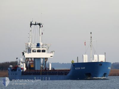
WILSON SAAR
General Cargo

Current Trip
KVINESDAL
| Time Travelled | 7 days |
|---|---|
| Remaining Time | --- |
| Distance Travelled | 1186.54 nm |
| Remaining Distance | --- |
| AVG Speed | 8.7 Noeuds |
| MAX Speed | 12.3 Noeuds |
| AVG Wind | 12.4 knots |
| MAX Wind | 35 knots |
| MIN Temp | 4.5°C / 40.1°F |
| MAX Temp | 10.5°C / 50.9°F |
| Tirant d eau | 3.4 m |
| Position reçue | 2 m depuis |
Current Position
| Longitude | --- |
|---|---|
| Latitude | --- |
| Etat | Moored |
| Vitesse | |
| Parcours | 59° |
| Zone | North Sea |
| Station | T-AIS |
| Position reçue | 2 m depuis |
Information
The current position of WILSON SAAR is in North Sea with coordinates 58.27517° / 6.88645° as reported on 2025-03-29 17:32 by AIS to our vessel tracker app. The vessel's current speed is 0 Noeuds
The vessel WILSON SAAR (IMO: 9125841, MMSI: 314261000) is a General Cargo that was built in 1996 ( 29 Age ). It's sailing under the flag of [BB] Barbados.
In this page you can find informations about the vessels current position, last detected port calls, and current voyage information. If the vessels is not in coverage by AIS you will find the latest position.
The current position of WILSON SAAR is detected by our AIS receivers and we are not responsible for the reliability of the data. The last position was recorded while the vessel was in Coverage by the Ais receivers of our vessel tracking app.
The current draught of WILSON SAAR as reported by AIS is 3.4 meters
Weather
| Temperature | 4.6°C / 40.28°F |
|---|---|
| Wind Speed | 8 knots |
| Direction | 241° WSW |
| Pressure | 1011.2 hPa |
| Humidity | 80.3 % |
| Cloud Coverage | 66 % |


Featured Company
Last Port Calls
| Port | Arrival | Departure | Time In Port |
|---|---|---|---|
| 2025-03-21 19:57 | 2025-03-22 06:15 | 10 h | |
| 2025-03-21 09:06 | 2025-03-21 18:17 | 9 h | |
| 2025-03-16 07:31 | 2025-03-17 19:09 | 1 d | |
| 2025-03-12 20:49 | 2025-03-13 10:53 | 14 h | |
| 2025-03-10 07:29 | 2025-03-11 16:14 | 1 d | |
| 2025-03-07 14:08 | 2025-03-07 22:00 | 7 h | |
| 2025-02-27 05:05 | 2025-02-27 18:55 | 13 h | |
| 2025-02-26 07:28 | 2025-02-26 13:19 | 5 h | |
| 2025-02-24 21:40 | 2025-02-25 08:43 | 11 h | |
| 2025-02-22 12:32 | 2025-02-23 00:22 | 11 h |
Last Trips
| Origin | Departure | Destination | Arrival | Distance | |
|---|---|---|---|---|---|
| 2025-03-21 18:17 | 2025-03-21 19:57 | 15.12 nm | |||
| 2025-03-17 19:09 | 2025-03-21 09:06 | 239.33 nm | |||
| 2025-03-13 10:53 | 2025-03-16 07:31 | 473.84 nm | |||
| 2025-03-11 16:14 | 2025-03-12 20:49 | 264.43 nm | |||
| 2025-03-07 22:00 | 2025-03-10 07:29 | 490.24 nm | |||
| 2025-02-27 18:55 | 2025-03-07 14:08 | 421.79 nm | |||
| 2025-02-26 13:19 | 2025-02-27 05:05 | 132.07 nm | |||
| 2025-02-25 08:43 | 2025-02-26 07:28 | 174.63 nm | |||
| 2025-02-23 00:22 | 2025-02-24 21:40 | 317.61 nm | |||
| 2025-02-20 18:09 | 2025-02-22 12:32 | 110.82 nm |
Events
| Heure | Evenement | Détails | Position/ Destination | Info |
|---|---|---|---|---|
| 2025-03-28 19:17 | Etat Changé | Moored Under way using engine |
58.27518 / 6.88648
KVINESDAL
|
Vitesse: Parcours: 59° |
| 2025-03-28 19:09 | Arret | 7.37 nm, East of FLEKKEFJORD |
58.27510 / 6.88615
KVINESDAL
|
Vitesse: 0.1 kn Parcours: 60° |
| 2025-03-28 09:41 | Changement de destination | KVINESDAL PETERHEAD FOR ORDERS |
58.41749 / 4.25305
KVINESDAL
|
Vitesse: 9.4 kn Parcours: 102° |
| 2025-03-28 09:41 | Changement d'ETA | 2025/03/28 19:00 2025/03/27 12:00 |
58.41749 / 4.25305
KVINESDAL
|
Vitesse: 9.4 kn Parcours: 102° |
| 2025-03-28 08:59 | Detecté en mer | Norwegian part of the North Sea |
58.44062 / 4.05004
North Sea
|
Vitesse: 9.8 kn Parcours: 105.6° |
| 2025-03-28 08:59 | Etat Changé | Under way using engine Default |
58.44062 / 4.05004
PETERHEAD FOR ORDERS
|
Vitesse: 9.8 kn Parcours: 103° |
| 2025-03-28 08:42 | Dans la zone couverte |
58.44062 / 4.05004
North Sea
|
Vitesse: 9.8 kn Parcours: 105.6° |
|
| 2025-03-27 04:20 | Etat Changé | Default Under way using engine |
58.58281 / -2.98091
PETERHEAD FOR ORDERS
|
Vitesse: 9.9 kn Parcours: 174.5° |
| 2025-03-27 04:13 | Hors de la zone couverte |
58.60084 / -2.98409
North Sea
PETERHEAD FOR ORDERS
|
Vitesse: 9.9 kn Parcours: 174.5° |
|
| 2025-03-27 02:34 | Changement de zone | United Kingdom part of the North Sea United Kingdom part of the North Atlantic Ocean |
58.69132 / -3.39999
North Sea
PETERHEAD FOR ORDERS
|
Vitesse: 5.7 kn Parcours: 90.1° |